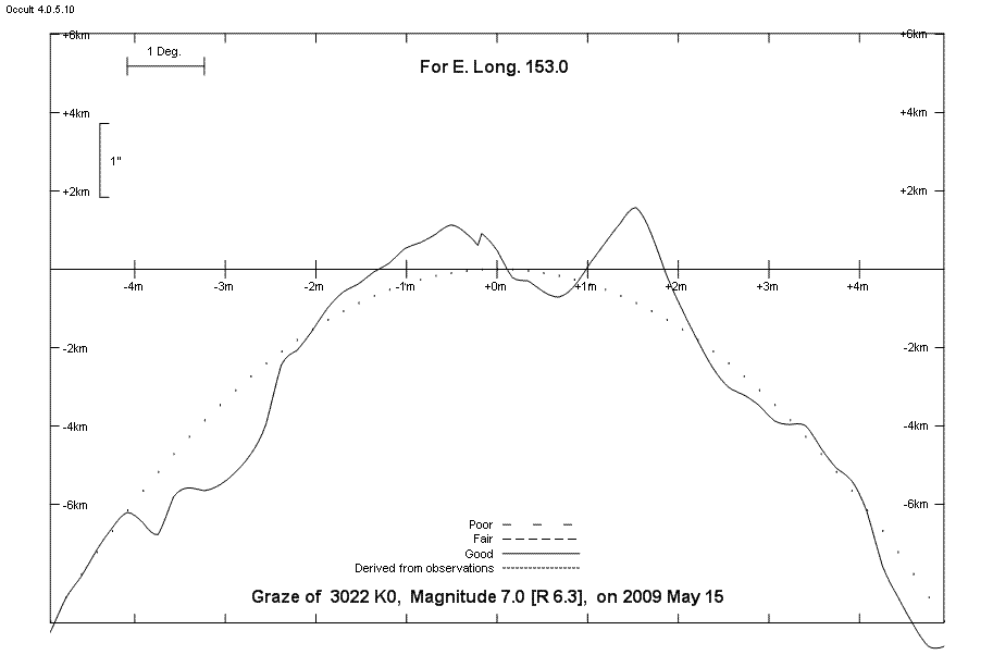
Predictions for Grazing Occultation of ZC 3022, 2009 May 15
Grazing Occultation of    3022 K0      Magnitude 7.0 [Red = 6.3]
Date: 2009 May 15 17h 58m,  to  2009 May 15 19h  2m

Nominal site altitude 5m

E. Longit.   Latitude     U.T.    Sun  Moon   TanZ   PA    AA      CA
   o  '  "    o  '  "   h  m  s   Alt Alt Az          o     o      o
 143  0  0  -30 52 41  18 21 53       69  56  0.39 331.0 344.47  13.79N
 143 30  0  -30 41 55  18 23 26       69  54  0.38 330.8 344.21  14.05N
 144  0  0  -30 30 47  18 25  0       70  53  0.36 330.5 343.95  14.31N
 144 30  0  -30 19 17  18 26 35       71  52  0.35 330.2 343.69  14.57N
 145  0  0  -30  7 25  18 28 12       72  50  0.33 330.0 343.43  14.83N
 145 30  0  -29 55 11  18 29 49       72  49  0.32 329.7 343.17  15.09N
 146  0  0  -29 42 34  18 31 28       73  47  0.31 329.5 342.91  15.35N
 146 30  0  -29 29 34  18 33  8       74  45  0.29 329.2 342.65  15.61N
 147  0  0  -29 16 11  18 34 49       74  43  0.28 328.9 342.39  15.87N
 147 30  0  -29  2 23  18 36 31       75  41  0.27 328.7 342.13  16.13N
 148  0  0  -28 48 12  18 38 14       76  39  0.25 328.4 341.87  16.39N
 148 30  0  -28 33 37  18 39 58       77  37  0.24 328.2 341.62  16.64N
 149  0  0  -28 18 37  18 41 44       77  34  0.23 327.9 341.37  16.90N
 149 30  0  -28  3 13  18 43 30       78  31  0.21 327.7 341.11  17.15N
 150  0  0  -27 47 24  18 45 18       79  27  0.20 327.4 340.86  17.40N
 150 30  0  -27 31  9  18 47  6       79  24  0.19 327.2 340.62  17.64N
 151  0  0  -27 14 30  18 48 55       80  20  0.18 326.9 340.37  17.89N
 151 30  0  -26 57 25  18 50 46       80  15  0.17 326.7 340.13  18.13N
 152  0  0  -26 39 54  18 52 37       81  10  0.16 326.4 339.90  18.36N
 152 30  0  -26 21 58  18 54 29       81   4  0.16 326.2 339.66  18.60N
 153  0  0  -26  3 37  18 56 22       81 358  0.15 326.0 339.43  18.83N
 153 30  0  -25 44 50  18 58 16       82 352  0.15 325.7 339.21  19.05N
 154  0  0  -25 25 38  19  0 10       82 345  0.14 325.5 338.99  19.27N
 154 30  0  -25  6  0  19  2  5       82 338  0.14 325.3 338.78  19.48N

Path coordinates are referred to WGS84 (as used by GPS), with the
nominal site altitude being referenced to Mean Sea Level.

Projected diameter of star  2 meters


                Librations  Long -3.15   Lat -0.76
                            P +343.76     D +1.88
      Illumination of moon  64%-
        Elongation of Moon  107
    Vertical Profile Scale  1.88 km/arcsec at mean distance of moon
   Horizontal Scale Factor  1.19 deg/min


At longitude 144.50:
Limiting Magnitudes for various telescope apertures (in cm)
      CA\Tdia   5    10    15    20    25    30    35
    10.6      5.8   7.3   8.1   8.6   9.0   9.3   9.5
    12.6      5.8   7.3   8.1   8.7   9.0   9.3   9.5
    14.6      5.8   7.3   8.1   8.7   9.0   9.3   9.6
    16.6      5.8   7.3   8.1   8.7   9.1   9.3   9.6
    18.6      5.9   7.3   8.1   8.7   9.1   9.4   9.6
Lunar Limb Profile - Maryborough