Predictions for Grazing Occultation of SAO 145718, 2009 Nov 24
Grazing Occultation of  145718 F5      Magnitude 7.2 [Red = 7.0]
Date: 2009 Nov 24 10h 39m,  to  2009 Nov 24 11h 33m

Nominal site altitude 5m

E. Longit.   Latitude     U.T.    Sun  Moon   TanZ   PA    AA      CA
   o  '  "    o  '  "   h  m  s   Alt Alt Az          o     o      o
 135  0  0  -38 37 40  10 40 45   -8  50 309  0.84 143.4 161.86  16.55S
 135 30  0  -38 10 17  10 42 18   -8  50 307  0.84 143.3 161.85  16.56S
 136  0  0  -37 42 51  10 43 52   -9  50 306  0.85 143.3 161.83  16.58S
 136 30  0  -37 15 22  10 45 26  -10  49 304  0.86 143.3 161.83  16.58S
 137  0  0  -36 47 52  10 46 59  -11  49 303  0.87 143.3 161.83  16.58S
 137 30  0  -36 20 22  10 48 34  -12  49 301  0.88 143.3 161.83  16.57S
 138  0  0  -35 52 54  10 50  8       48 300  0.90 143.3 161.85  16.56S
 138 30  0  -35 25 30  10 51 42       48 299  0.91 143.4 161.87  16.54S
 139  0  0  -34 58 10  10 53 15       47 297  0.92 143.4 161.89  16.51S
 139 30  0  -34 30 57  10 54 49       47 296  0.94 143.4 161.93  16.48S
 140  0  0  -34  3 51  10 56 22       46 295  0.95 143.5 161.97  16.44S
 140 30  0  -33 36 55  10 57 55       46 294  0.97 143.5 162.01  16.40S
 141  0  0  -33 10  9  10 59 27       45 292  0.99 143.6 162.06  16.34S
 141 30  0  -32 43 34  11  0 58       45 291  1.01 143.6 162.12  16.29S
 142  0  0  -32 17 13  11  2 28       44 290  1.02 143.7 162.19  16.22S
 142 30  0  -31 51  6  11  3 58       44 289  1.04 143.8 162.25  16.15S
 143  0  0  -31 25 15  11  5 27       43 288  1.07 143.8 162.33  16.08S
 143 30  0  -30 59 39  11  6 55       43 287  1.09 143.9 162.41  16.00S
 144  0  0  -30 34 21  11  8 21       42 286  1.11 144.0 162.49  15.91S
 144 30  0  -30  9 21  11  9 47       41 285  1.13 144.1 162.58  15.82S
 145  0  0  -29 44 40  11 11 11       41 284  1.16 144.2 162.68  15.73S
 145 30  0  -29 20 19  11 12 34       40 283  1.18 144.3 162.78  15.63S
 146  0  0  -28 56 18  11 13 56       40 282  1.21 144.4 162.88  15.53S
 146 30  0  -28 32 38  11 15 16       39 281  1.24 144.5 162.99  15.42S
 147  0  0  -28  9 19  11 16 35       38 281  1.27 144.6 163.10  15.31S
 147 30  0  -27 46 22  11 17 52       38 280  1.30 144.7 163.21  15.20S
 148  0  0  -27 23 47  11 19  8       37 279  1.33 144.8 163.33  15.08S
 148 30  0  -27  1 34  11 20 23       36 278  1.36 144.9 163.45  14.96S
 149  0  0  -26 39 44  11 21 36       36 278  1.39 145.1 163.57  14.84S
 149 30  0  -26 18 17  11 22 47       35 277  1.43 145.2 163.69  14.71S
 150  0  0  -25 57 13  11 23 57       34 276  1.47 145.3 163.82  14.59S
 150 30  0  -25 36 32  11 25  5       34 276  1.50 145.4 163.95  14.46S
 151  0  0  -25 16 14  11 26 12       33 275  1.54 145.6 164.08  14.33S
 151 30  0  -24 56 18  11 27 17       32 275  1.58 145.7 164.21  14.20S
 152  0  0  -24 36 46  11 28 20       32 274  1.62 145.8 164.35  14.06S
 152 30  0  -24 17 36  11 29 22       31 274  1.67 146.0 164.48  13.93S
 153  0  0  -23 58 50  11 30 22       30 273  1.71 146.1 164.62  13.79S
 153 30  0  -23 40 25  11 31 21       30 272  1.76 146.2 164.76  13.65S
 154  0  0  -23 22 24  11 32 18       29 272  1.81 146.4 164.89  13.52S

Path coordinates are referred to WGS84 (as used by GPS), with the
nominal site altitude being referenced to Mean Sea Level.


                Librations  Long -3.50   Lat -4.36
                            P +162.80     D -4.95
      Illumination of moon  45%+
        Elongation of Moon  85
    Vertical Profile Scale  2.39 km/arcsec at mean distance of moon
   Horizontal Scale Factor  1.49 deg/min
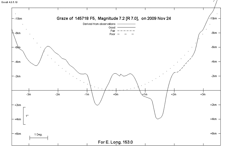
Lunar Limb Profile - Adelaide
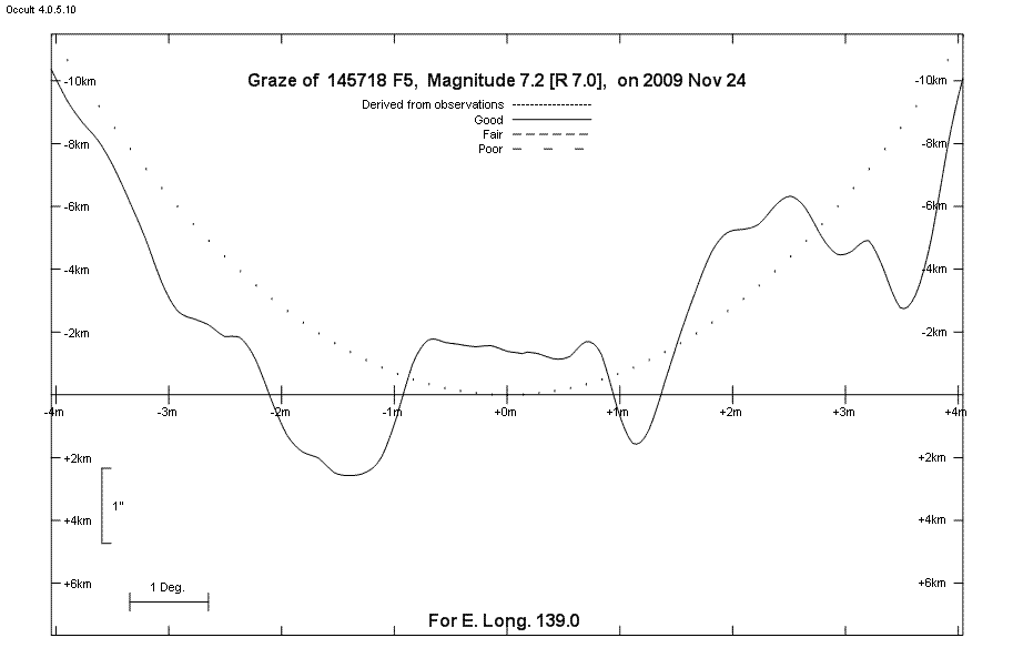
Lunar Limb Profile - South of Rockhampton