Predictions for Grazing Occultation of ZC 2307, 2012 Jul 28
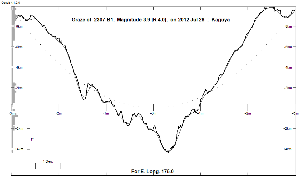
Graze profile
Grazing Occultation of ZC 2307 B1, Magnitude 3.9 [Red = 4.0]
   R2307 = Kow Kin = omega 1 Scorpii
Date: 2012 Jul 28 13h  3m,  to  2012 Jul 28 13h  6m

Nominal site altitude 100m

E. Longit.   Latitude     U.T.    Sun  Moon   TanZ   PA    AA      CA
   o  '  "    o  '  "   h  m  s   Alt Alt Az          o     o      o
 173  0  0  -38 44 39  13  3 14       25 263  2.11 179.0 166.62  12.08S
 173 10  0  -38 41 12  13  3 22       25 263  2.13 179.0 166.60  12.10S
 173 20  0  -38 37 45  13  3 30       25 263  2.15 178.9 166.59  12.11S
 173 30  0  -38 34 17  13  3 38       25 263  2.16 178.9 166.58  12.12S
 173 40  0  -38 30 48  13  3 45       25 262  2.18 178.9 166.57  12.14S
 173 50  1  -38 27 19  13  3 53       24 262  2.19 178.9 166.55  12.15S
 174  0  1  -38 23 50  13  4  1       24 262  2.21 178.9 166.54  12.16S
 174 10  1  -38 20 20  13  4  8       24 262  2.23 178.9 166.53  12.17S
 174 20  1  -38 16 50  13  4 16       24 262  2.24 178.9 166.52  12.18S
 174 30  1  -38 13 19  13  4 23       24 262  2.26 178.9 166.51  12.19S
 174 40  1  -38  9 48  13  4 31       24 262  2.28 178.9 166.50  12.20S
 174 50  1  -38  6 16  13  4 38       24 261  2.30 178.8 166.49  12.22S
 175  0  1  -38  2 44  13  4 46       23 261  2.32 178.8 166.47  12.23S
 175 10  2  -37 59 11  13  4 53       23 261  2.33 178.8 166.46  12.24S
 175 20  2  -37 55 39  13  5  0       23 261  2.35 178.8 166.45  12.25S
 175 30  2  -37 52  5  13  5  7       23 261  2.37 178.8 166.44  12.26S
 175 40  2  -37 48 32  13  5 15       23 261  2.39 178.8 166.43  12.27S
 175 50  2  -37 44 57  13  5 22       23 261  2.41 178.8 166.42  12.28S
 176  0  2  -37 41 23  13  5 29       22 260  2.43 178.8 166.41  12.29S
 176 10  2  -37 37 48  13  5 36       22 260  2.45 178.8 166.40  12.30S
 176 20  2  -37 34 13  13  5 43       22 260  2.47 178.7 166.39  12.31S
 176 30  3  -37 30 37  13  5 50       22 260  2.49 178.7 166.38  12.32S
 176 40  3  -37 27  1  13  5 57       22 260  2.51 178.7 166.37  12.33S
 176 50  3  -37 23 24  13  6  4       22 260  2.53 178.7 166.36  12.34S

Path coordinates are referred to WGS84 (as used by GPS), with the
nominal site altitude being referenced to Mean Sea Level.


                Librations  Long -1.14   Lat -0.54
                            P +166.48     D -0.53
      Illumination of moon  73%+
        Elongation of Moon  118
    Vertical Profile Scale  2.06 km/arcsec at mean distance of moon
   Horizontal Scale Factor  1.92 deg/min


At longitude 175.00:
Limiting Magnitudes for various telescope apertures (in cm)
      CA\Tdia   5    10    15    20    25    30    35
     8.2      5.2   6.6   7.4   7.8   8.1   8.3   8.4
    10.2      5.3   6.7   7.4   7.8   8.1   8.3   8.5
    12.2      5.3   6.7   7.4   7.8   8.1   8.3   8.5
    14.2      5.3   6.7   7.4   7.9   8.2   8.3   8.5
    16.2      5.3   6.7   7.4   7.9   8.2   8.4   8.5

------------------------------------------------------------------------------
Results of Observer Scan                                    UT
Site                              Long.   Lat.   Dist.    h  m  s
Auckland                          174.8  -36.9   123km   13  4 37
MidNZ                             173.0  -41.0   227km   13  3 14
Wellington                        174.8  -41.3   319km   13  4 37
Lunar Limb Profile