Predictions for Grazing Occultation of SAO 159004, 2012 October 17
Graze profile
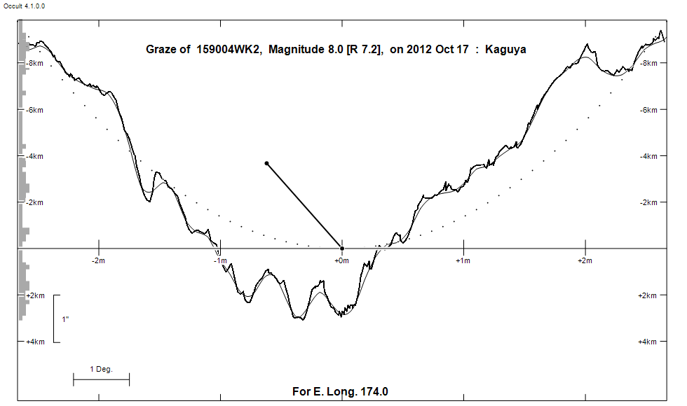
Grazing Occultation of  159004WK2      Magnitude 8.0 [Red = 7.2]
Date: 2012 Oct 17  7h 59m,  to  2012 Oct 17  7h 59m

Nominal site altitude 100m

E. Longit.   Latitude     U.T.    Sun  Moon   TanZ   PA    AA      CA
   o  '  "    o  '  "   h  m  s   Alt Alt Az          o     o      o
 173  0  0  -36 35 40   7 58 35        9 254  6.66 184.7 167.17  11.84S
 173 10  0  -36 32 32   7 58 37        8 254  6.78 184.6 167.16  11.85S
 173 20  0  -36 29 24   7 58 39        8 254  6.91 184.6 167.15  11.86S
 173 30  0  -36 26 16   7 58 42        8 254  7.04 184.6 167.14  11.87S
 173 40  0  -36 23  7   7 58 44        8 254  7.17 184.6 167.14  11.88S
 173 50  1  -36 19 59   7 58 46        8 253  7.31 184.6 167.13  11.88S
 174  0  1  -36 16 50   7 58 48        8 253  7.46 184.6 167.12  11.89S
 174 10  1  -36 13 40   7 58 50        7 253  7.61 184.6 167.11  11.90S
 174 20  1  -36 10 31   7 58 52        7 253  7.77 184.6 167.11  11.91S
 174 30  1  -36  7 21   7 58 54        7 253  7.93 184.6 167.10  11.91S
 174 40  1  -36  4 10   7 58 56        7 253  8.10 184.6 167.09  11.92S
 174 50  1  -36  1  0   7 58 58        7 253  8.28 184.6 167.08  11.93S
 175  0  1  -35 57 49   7 59  0        7 253  8.47 184.6 167.08  11.94S
 175 10  2  -35 54 38   7 59  1        7 253  8.66 184.6 167.07  11.94S
 175 20  2  -35 51 27   7 59  3        6 253  8.87 184.5 167.06  11.95S
 175 30  2  -35 48 16   7 59  5        6 252  9.08 184.5 167.05  11.96S
 175 40  2  -35 45  4   7 59  6        6 252  9.31 184.5 167.05  11.97S
 175 50  2  -35 41 52   7 59  8        6 252  9.54 184.5 167.04  11.97S
 176  0  2  -35 38 40   7 59 10        6 252  9.79 184.5 167.03  11.98S
 176 10  2  -35 35 27   7 59 11        6 252 10.05 184.5 167.03  11.99S
 176 20  2  -35 32 15   7 59 13        6 252 10.33 184.5 167.02  11.99S
 176 30  3  -35 29  2   7 59 14        5 252 10.62 184.5 167.01  12.00S
 176 40  3  -35 25 48   7 59 16        5 252 10.93 184.5 167.01  12.01S
 176 50  3  -35 22 35   7 59 17        5 252 11.25 184.5 167.00  12.01S

Path coordinates are referred to WGS84 (as used by GPS), with the
nominal site altitude being referenced to Mean Sea Level.

Projected diameter of star  2 meters  [Estimated]

159004 is double:
  AB 8.1 8.9 24.7"  89.9 (S   665) Graze path of B 4.34 km south, and 38.9 secs later compared to A

                Librations  Long -0.54   Lat +0.49
                            P +167.07     D +0.61
      Illumination of moon  5%+
        Elongation of Moon  25
    Vertical Profile Scale  2.05 km/arcsec at mean distance of moon
   Horizontal Scale Factor  2.19 deg/min


At longitude 175.00:
Limiting Magnitudes for various telescope apertures (in cm)
      CA\Tdia   5    10    15    20    25    30    35
     7.9      7.1   8.6   9.4  10.0  10.4  10.7  10.9
     9.9      7.1   8.6   9.4  10.0  10.4  10.7  10.9
    11.9      7.1   8.6   9.4  10.0  10.4  10.7  11.0
    13.9      7.1   8.6   9.4  10.0  10.4  10.7  11.0
    15.9      7.1   8.6   9.5  10.0  10.4  10.8  11.0

------------------------------------------------------------------------------
Double star catalogue details
WDS entries

  RA  Dec Name          Y1   Y2     N  PA  PA   Sep   Sep  M1    M2
15045-1754S   665      1825 2003   20  91  90  25.1  24.7  8.07  8.88           -015-001 -016+005 -17 4246 N D  150430.89-175413.0

------------------------------------------------
Interferometric catalogue entries

150430.89-175413.0  BD-17 4246                S   665                   HD 133353    HIP  73751         15045-1754 N
    Date       PA              Sep                  M1             M2
  1991.25      90.4     .     25.07       .         8.09    .      8.97    .       550       0.3   1  HIP1997a Thp
  1991.25        .      .       .         .         8.018  0.018   8.809  0.030    530 100   1.4   1  TYC1997  Tty
  1991.25        .      .       .         .         9.505  0.032  10.036  0.049    430  90   1.4   1  TYC1997  Tty
  1991.25        .      .       .         .         8.087  0.027   8.967  0.048    511 222   0.3   1  HIP1997f Thp
  1991.57      90.5     .     25.065      .         8.074  0.013   8.882  0.020    530 100   1.4   1  TYC2000b Tty
  1991.57        .      .       .         .         9.601  0.025  10.184  0.034    430  90   1.4   1  TYC2000b Tty


------------------------------------------------------------------------------
Results of Observer Scan                                    UT
Site                              Long.   Lat.   Dist.    h  m  s
Auckland                          174.8  -36.9    90km    7 58 57
MidNZ                             173.0  -41.0   451km    7 58 35
Lunar Limb Profile