Predictions for Grazing Occultation of ZC 1410, 2013 Apr 20, near Nambour, Qld
Graze profile
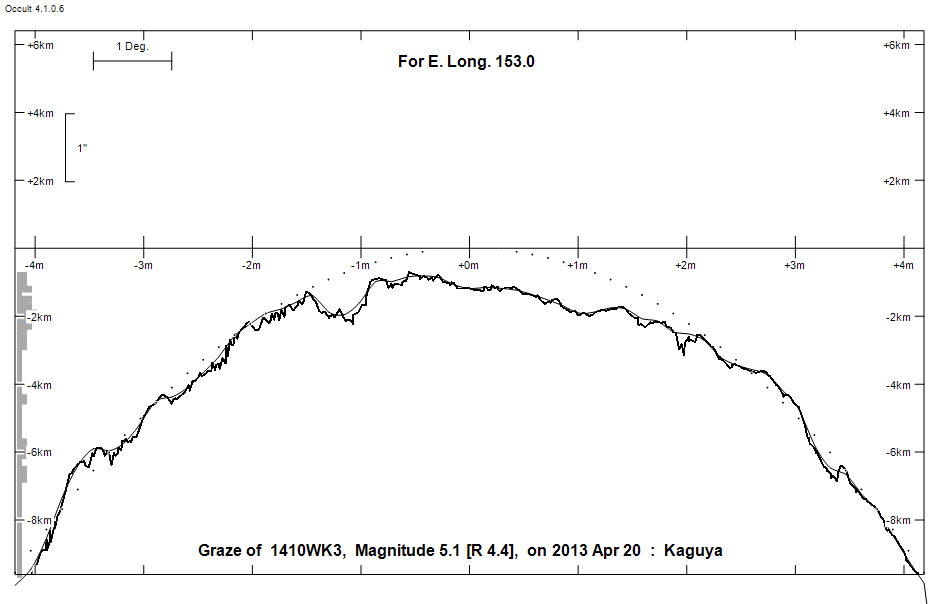
Grazing Occultation of    1410WK3      Magnitude 5.1 [Red = 4.4]
   R1410 = 6 Leonis
Date: 2013 Apr 20 11h 39m,  to  2013 Apr 20 11h 51m

Nominal site altitude 50m

E. Longit.   Latitude     U.T.    Sun  Moon   TanZ   PA    AA      CA
   o  '  "    o  '  "   h  m  s   Alt Alt Az          o     o      o
 149  0  0  -24 10 10  11 38 56       46 316  0.97  30.8  12.10  14.19N
 149 30  0  -24 27 22  11 40  6       45 316  1.00  30.7  12.00  14.08N
 150  0  0  -24 44 23  11 41 15       44 315  1.02  30.6  11.89  13.98N
 150 30  0  -25  1 13  11 42 22       44 314  1.05  30.5  11.78  13.87N
 151  0  0  -25 17 50  11 43 27       43 314  1.07  30.4  11.67  13.76N
 151 30  0  -25 34 17  11 44 32       42 313  1.10  30.3  11.56  13.64N
 152  0  0  -25 50 32  11 45 34       42 313  1.13  30.2  11.45  13.53N
 152 30  0  -26  6 35  11 46 36       41 312  1.15  30.1  11.33  13.42N
 153  0  0  -26 22 27  11 47 36       40 311  1.18  30.0  11.22  13.31N
 153 30  0  -26 38  8  11 48 35       40 311  1.21  29.8  11.10  13.19N
 154  0  0  -26 53 37  11 49 33       39 310  1.24  29.7  10.99  13.08N
 154 30  0  -27  8 54  11 50 29       38 310  1.27  29.6  10.87  12.96N
 155  0  0  -27 24  0  11 51 24       38 309  1.30  29.5  10.76  12.84N

Path coordinates are referred to WGS84 (as used by GPS), with the
nominal site altitude being referenced to Mean Sea Level.

Projected diameter of star  5 meters  [CHARM/CADARS, 7 measures]

1410 is double:
  AB 5.2 9.3 38"  75.0 (SHJ 107) Graze path of B 52.48 km south, and 72.9 secs later compared to A

                Librations  Long -6.81   Lat +6.44
                            P +10.72     D -7.40
      Illumination of moon  68%+
        Elongation of Moon  112
    Vertical Profile Scale  2.00 km/arcsec at mean distance of moon
   Horizontal Scale Factor  1.37 deg/min


At longitude 152.00:
Limiting Magnitudes for various telescope apertures (in cm)
      CA\Tdia   5    10    15    20    25    30    35
     9.5      5.6   7.1   7.9   8.4   8.7   9.0   9.1
    11.5      5.6   7.1   7.9   8.4   8.7   9.0   9.2
    13.5      5.6   7.1   7.9   8.4   8.7   9.0   9.2
    15.5      5.7   7.1   7.9   8.4   8.7   9.0   9.2
    17.5      5.7   7.1   7.9   8.4   8.8   9.0   9.2

------------------------------------------------------------------------------
Double star catalogue details
WDS entries

  RA  Dec Name          Y1   Y2     N  PA  PA   Sep   Sep  M1    M2
09320+0943SHJ 107      1781 2011   51  77  75  36.2  38.0  5.22  9.30 K3III     -009-013 -012-017 +10 2014 N D  093157.58+094256.8

------------------------------------------------
Interferometric catalogue entries

093157.58+094256.8  ADS  7416                 SHJ 107                   BD+10 2014   HIP  46774         09320+0943 N
    Date       PA              Sep                  M1             M2
  1991.25        .      .   <  0.1        .         5.22    .       .      .       511 222   0.3   1  HIP1997e Hh
  1991.52      75.1     .     37.37       .         5.216  0.009   9.300  0.041    530 100   1.4   1  TYC2002  Ht
  1991.52        .      .       .         .         6.830  0.015   9.880  0.046    430  90   1.4   1  TYC2002  Ht


------------------------------------------------------------------------------
Results of Observer Scan                                    UT
Site                              Long.   Lat.   Dist.    h  m  s
Brisbane                          153.1  -27.5   102km   11 47 42
Bundaberg                         152.3  -24.8   117km   11 46 16
Rockhampton                       150.5  -23.4   157km   11 42 22
Lunar Limb Profile