Predictions for Grazing Occultation of ZC 2322, 2013 Jun 21 near Rockhampton
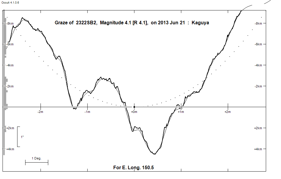
Graze profile
Grazing Occultation of    2322SB2      Magnitude 4.1 [Red = 4.1]
   R2322 = jabbah = nu Scorpii
Date: 2013 Jun 21 17h 46m,  to  2013 Jun 21 17h 48m

Nominal site altitude 50m

E. Longit.   Latitude     U.T.    Sun  Moon   TanZ   PA    AA      CA
   o  '  "    o  '  "   h  m  s   Alt Alt Az          o     o      o
 149  0  0  -23 21 18  17 45 56       14 255  3.93 177.9 166.11  16.37S
 149 30  0  -23 10 35  17 46 10       14 254  4.09 177.9 166.10  16.39S
 150  0  0  -22 59 51  17 46 22       13 254  4.27 177.9 166.09  16.40S
 150 30  0  -22 49  6  17 46 35       13 254  4.45 177.9 166.08  16.41S
 151  0  0  -22 38 20  17 46 47       12 254  4.66 177.9 166.07  16.42S
 151 30  0  -22 27 33  17 46 58       12 254  4.88 177.9 166.06  16.42S
 152  0  0  -22 16 46  17 47  9       11 253  5.12 177.9 166.05  16.43S
 152 30  0  -22  5 58  17 47 20       11 253  5.39 177.8 166.05  16.44S
 153  0  0  -21 55  9  17 47 29       10 253  5.68 177.8 166.04  16.45S
 153 30  0  -21 44 19  17 47 39        9 253  6.01 177.8 166.03  16.45S
 154  0  0  -21 33 29  17 47 48        9 252  6.37 177.8 166.03  16.45S
 154 30  0  -21 22 39  17 47 56        8 252  6.78 177.8 166.03  16.46S
 155  0  0  -21 11 48  17 48  4        8 252  7.24 177.8 166.02  16.46S

Path coordinates are referred to WGS84 (as used by GPS), with the
nominal site altitude being referenced to Mean Sea Level.

2322 is quadruple:
  Aa,Ab 4.0           162.3 (CHR 146) Graze path of Ab 0.04 km north, and 0.0 secs later compared to Aa
  AB 4.3 5.3 1.3"   1.0 (BU  120) Graze path of B 2.71 km south, and 0.1 secs later compared to A
  AC 4.3 6.6 41" 337.0 (H 5   6) Graze path of C 78.90 km south, and 24.3 secs earlier compared to A

                Librations  Long -4.64   Lat -2.44
                            P +166.25     D -3.22
      Illumination of moon  95%+
        Elongation of Moon  154
    Vertical Profile Scale  1.92 km/arcsec at mean distance of moon
   Horizontal Scale Factor  2.09 deg/min


At longitude 152.00:
Limiting Magnitudes for various telescope apertures (in cm)
      CA\Tdia   5    10    15    20    25    30    35
    12.4      3.5   4.8   5.4   5.7   5.9   6.0   6.1
    14.4      3.6   4.8   5.4   5.7   5.9   6.0   6.1
    16.4      3.8   5.0   5.6   5.9   6.1   6.2   6.3
    18.4      4.0   5.3   5.9   6.3   6.5   6.6   6.7
    20.4      4.3   5.6   6.2   6.6   6.8   6.9   7.0

------------------------------------------------------------------------------
Double star catalogue details
WDS entries

  RA  Dec Name          Y1   Y2     N  PA  PA   Sep   Sep  M1    M2
16120-1928CHR 146Aa,Ab 1988 2012    6 172 346   0.1   0.1  4.01       B3V       -010-026          -19 4333 N    161159.74-192738.3
16120-1928BU  120AB    1873 2012  100   0   1   0.3   1.4  4.35  5.31           -008-000                   N D  161159.74-192738.3
16120-1928H 5   6AC    1777 2010   72 335 337  42.0  41.2  4.35  6.60           -011-016 -021-035 -19 4332 N D  161159.74-192738.3
16120-1928MTL   2CD    1846 2011   93  39  55   1.1   2.2  6.60  7.23 B8/9V     -021-035 -021-035 -19 4332 N    161158.60-192700.1

------------------------------------------------------------------------------
Results of Observer Scan                                    UT
Site                              Long.   Lat.   Dist.    h  m  s
Albany                            117.8  -35.0   259km   17 15  2
Bundaberg                         152.3  -24.8   272km   17 47 16
Perth                             115.9  -32.0   111km   17 12  5
Rockhampton                       150.5  -23.4    57km   17 46 35
Lunar Limb Profile