Predictions for Grazing Occultation of ZC 2401, 2013 Jul 19 near Bundaberg
Graze profile
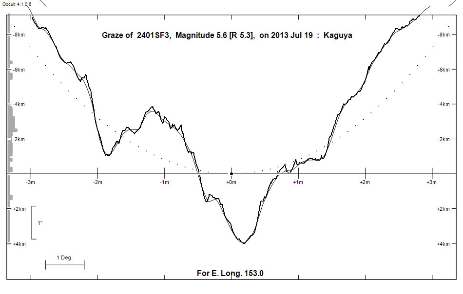
Grazing Occultation of    2401SF3      Magnitude 5.6 [Red = 5.3]
Date: 2013 Jul 19 14h 12m,  to  2013 Jul 19 14h 44m

Nominal site altitude 50m

E. Longit.   Latitude     U.T.    Sun  Moon   TanZ   PA    AA      CA
   o  '  "    o  '  "   h  m  s   Alt Alt Az          o     o      o
 133  0  0  -29 49 45  14 11 43       59 281  0.61 178.8 169.83  11.34S
 133 30  0  -29 44  6  14 12 37       58 280  0.62 178.6 169.72  11.45S
 134  0  0  -29 38 18  14 13 30       58 279  0.63 178.5 169.60  11.56S
 134 30  0  -29 32 21  14 14 23       57 279  0.65 178.4 169.49  11.67S
 135  0  0  -29 26 14  14 15 16       56 278  0.66 178.3 169.38  11.78S
 135 30  0  -29 19 59  14 16  8       56 277  0.68 178.2 169.28  11.89S
 136  0  0  -29 13 34  14 17  0       55 277  0.70 178.1 169.17  11.99S
 136 30  0  -29  7  1  14 17 52       55 276  0.71 178.0 169.07  12.10S
 137  0  0  -29  0 20  14 18 43       54 275  0.73 177.9 168.96  12.20S
 137 30  0  -28 53 29  14 19 34       53 275  0.74 177.8 168.86  12.30S
 138  0  0  -28 46 31  14 20 24       53 274  0.76 177.7 168.77  12.40S
 138 30  0  -28 39 24  14 21 14       52 274  0.78 177.6 168.67  12.49S
 139  0  0  -28 32  9  14 22  4       51 273  0.80 177.5 168.57  12.59S
 139 30  0  -28 24 46  14 22 53       51 273  0.81 177.4 168.48  12.68S
 140  0  0  -28 17 14  14 23 42       50 272  0.83 177.3 168.39  12.77S
 140 30  0  -28  9 35  14 24 30       50 272  0.85 177.2 168.30  12.86S
 141  0  0  -28  1 49  14 25 18       49 271  0.87 177.1 168.21  12.95S
 141 30  0  -27 53 54  14 26  5       48 271  0.89 177.1 168.13  13.04S
 142  0  0  -27 45 52  14 26 52       48 270  0.91 177.0 168.04  13.12S
 142 30  0  -27 37 43  14 27 39       47 270  0.93 176.9 167.96  13.20S
 143  0  0  -27 29 27  14 28 25       47 269  0.95 176.8 167.88  13.28S
 143 30  0  -27 21  3  14 29 10       46 269  0.97 176.7 167.80  13.36S
 144  0  0  -27 12 33  14 29 55       45 268  0.99 176.7 167.73  13.44S
 144 30  0  -27  3 56  14 30 40       45 268  1.01 176.6 167.65  13.51S
 145  0  0  -26 55 12  14 31 24       44 268  1.03 176.5 167.58  13.58S
 145 30  0  -26 46 21  14 32  7       43 267  1.05 176.4 167.51  13.65S
 146  0  0  -26 37 24  14 32 50       43 267  1.08 176.4 167.44  13.72S
 146 30  0  -26 28 21  14 33 33       42 266  1.10 176.3 167.37  13.79S
 147  0  0  -26 19 12  14 34 15       42 266  1.12 176.2 167.31  13.86S
 147 30  0  -26  9 56  14 34 56       41 266  1.15 176.2 167.24  13.92S
 148  0  0  -26  0 35  14 35 37       40 265  1.17 176.1 167.18  13.98S
 148 30  0  -25 51  8  14 36 18       40 265  1.20 176.1 167.12  14.04S
 149  0  0  -25 41 36  14 36 58       39 264  1.23 176.0 167.06  14.10S
 149 30  0  -25 31 58  14 37 37       39 264  1.25 175.9 167.00  14.16S
 150  0  0  -25 22 14  14 38 16       38 264  1.28 175.9 166.95  14.21S
 150 30  0  -25 12 26  14 38 54       37 263  1.31 175.8 166.89  14.27S
 151  0  0  -25  2 32  14 39 31       37 263  1.34 175.8 166.83  14.33S
 151 30  0  -24 52 34  14 40  9       36 263  1.37 175.7 166.78  14.38S
 152  0  0  -24 42 31  14 40 45       36 262  1.40 175.7 166.74  14.43S
 152 30  0  -24 32 23  14 41 21       35 262  1.43 175.6 166.69  14.47S
 153  0  0  -24 22 11  14 41 56       34 262  1.47 175.6 166.64  14.52S
 153 30  0  -24 11 54  14 42 31       34 261  1.50 175.5 166.60  14.56S
 154  0  0  -24  1 34  14 43  5       33 261  1.53 175.5 166.56  14.60S
 154 30  0  -23 51  9  14 43 39       32 261  1.57 175.5 166.52  14.64S
 155  0  0  -23 40 41  14 44 12       32 260  1.61 175.4 166.48  14.68S

Path coordinates are referred to WGS84 (as used by GPS), with the
nominal site altitude being referenced to Mean Sea Level.

Projected diameter of star  1 meters  [Estimated]

2401 is triple:
  This next pair is not confirmed
  ** 5.6      0.007" 261.0** (OCc1494) Graze path of ? 0.00 km north, and 0.0 secs earlier compared to the primary
  AB 5.6 13.6 25.7" 212.6 (KUI  73) Graze path of B 41.82 km north, and 32.9 secs earlier compared to A

                Librations  Long -4.75   Lat -3.29
                            P +167.99     D -3.96
      Illumination of moon  85%+
        Elongation of Moon  135
    Vertical Profile Scale  1.90 km/arcsec at mean distance of moon
   Horizontal Scale Factor  1.59 deg/min


At longitude 144.00:
Limiting Magnitudes for various telescope apertures (in cm)
      CA\Tdia   5    10    15    20    25    30    35
     9.4      5.1   6.5   7.3   7.8   8.1   8.3   8.5
    11.4      5.5   6.9   7.7   8.2   8.6   8.8   9.0
    13.4      5.5   7.0   7.7   8.2   8.6   8.8   9.0
    15.4      5.5   7.0   7.7   8.3   8.6   8.8   9.0
    17.4      5.5   7.0   7.8   8.3   8.6   8.9   9.0

------------------------------------------------------------------------------
Double star catalogue details
WDS entries

  RA  Dec Name          Y1   Y2     N  PA  PA   Sep   Sep  M1    M2
16419-1955KUI  73      1958 1998    2 214 213  22.5  24.8  5.57 13.6  F4IV-V    +031+046          -19 4406 N D  164153.67-195528.1

------------------------------------------------
Interferometric catalogue entries

164153.67-195528.1  HR 6202                   KUI  73                   HD 150453    HIP  81754         16419-1955 N
    Date       PA              Sep                  M1             M2
  1985.515       .      .   <  0.038      .          .      .       .      .       549  22   3.6   1  McA1987a Sc
  1991.25        .      .   O   .         .         5.55    .       .      .       511 222   0.3   1  HIP1997g Hh


------------------------------------------------------------------------------
Results of Observer Scan                                    UT
Site                              Long.   Lat.   Dist.    h  m  s
Bundaberg                         152.3  -24.8    21km   14 41  9
Perth                             115.9  -32.0    67km   13 38 15
Rockhampton                       150.5  -23.4   192km   14 38 54
Lunar Limb Profile - near Bundaberg