Predictions for Grazing Occultation of ZC 2680, 2013 Aug 17 near Millicent, SA and Newcastle
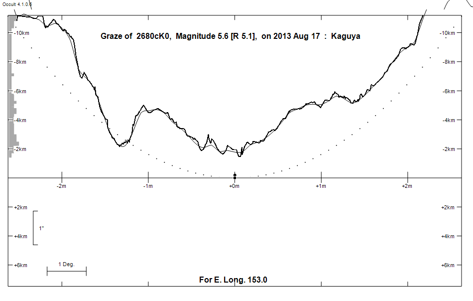
Graze profile Millicent | Newcastle
Grazing Occultation of    2680cK0      Magnitude 5.6 [Red = 5.1]
Date: 2013 Aug 17 16h 31m,  to  2013 Aug 17 16h 46m

Nominal site altitude 50m

E. Longit.   Latitude     U.T.    Sun  Moon   TanZ   PA    AA      CA
   o  '  "    o  '  "   h  m  s   Alt Alt Az          o     o      o
 133  0  0  -40 44  4  16 31 25       28 268  1.92 167.1 169.34  14.16S
 133 30  0  -40 30 45  16 31 56       27 268  1.96 167.1 169.33  14.17S
 134  0  0  -40 17 25  16 32 27       27 267  2.00 167.1 169.33  14.17S
 134 30  0  -40  4  4  16 32 57       26 267  2.04 167.1 169.33  14.17S
 135  0  0  -39 50 44  16 33 27       26 266  2.09 167.1 169.33  14.17S
 135 30  0  -39 37 24  16 33 56       25 266  2.14 167.1 169.33  14.17S
 136  0  0  -39 24  5  16 34 25       25 265  2.18 167.1 169.34  14.16S
 136 30  0  -39 10 46  16 34 53       24 265  2.24 167.1 169.34  14.16S
 137  0  0  -38 57 27  16 35 21       24 264  2.29 167.1 169.34  14.15S
 137 30  0  -38 44 10  16 35 48       23 264  2.34 167.1 169.35  14.15S
 138  0  0  -38 30 54  16 36 15       23 263  2.40 167.2 169.36  14.14S
 138 30  0  -38 17 39  16 36 41       22 263  2.46 167.2 169.37  14.13S
 139  0  0  -38  4 25  16 37  6       22 263  2.53 167.2 169.37  14.12S
 139 30  0  -37 51 14  16 37 31       21 262  2.59 167.2 169.38  14.11S
 140  0  0  -37 38  3  16 37 56       21 262  2.66 167.2 169.40  14.10S
 140 30  0  -37 24 55  16 38 20       20 261  2.73 167.2 169.41  14.09S
 141  0  0  -37 11 49  16 38 43       20 261  2.81 167.2 169.42  14.08S
 141 30  0  -36 58 45  16 39  6       19 261  2.89 167.2 169.43  14.07S
 142  0  0  -36 45 43  16 39 28       19 260  2.97 167.2 169.45  14.05S
 142 30  0  -36 32 44  16 39 49       18 260  3.06 167.3 169.46  14.03S
 143  0  0  -36 19 47  16 40 10       18 259  3.16 167.3 169.48  14.02S
 143 30  0  -36  6 53  16 40 31       17 259  3.26 167.3 169.50  14.00S
 144  0  0  -35 54  2  16 40 51       17 259  3.36 167.3 169.52  13.98S
 144 30  0  -35 41 14  16 41 10       16 258  3.47 167.3 169.53  13.96S
 145  0  0  -35 28 29  16 41 29       16 258  3.59 167.4 169.55  13.94S
 145 30  0  -35 15 47  16 41 47       15 257  3.72 167.4 169.57  13.92S
 146  0  0  -35  3  9  16 42  5       15 257  3.85 167.4 169.60  13.90S
 146 30  0  -34 50 34  16 42 21       14 257  4.00 167.4 169.62  13.88S
 147  0  0  -34 38  3  16 42 38       14 256  4.15 167.4 169.64  13.86S
 147 30  0  -34 25 35  16 42 54       13 256  4.32 167.5 169.66  13.84S
 148  0  0  -34 13 11  16 43  9       13 256  4.50 167.5 169.69  13.81S
 148 30  0  -34  0 50  16 43 24       12 255  4.69 167.5 169.71  13.79S
 149  0  0  -33 48 34  16 43 38       12 255  4.90 167.5 169.74  13.76S
 149 30  0  -33 36 22  16 43 51       11 255  5.13 167.6 169.76  13.74S
 150  0  0  -33 24 13  16 44  4       11 254  5.38 167.6 169.79  13.71S
 150 30  0  -33 12  9  16 44 16       10 254  5.65 167.6 169.82  13.68S
 151  0  0  -33  0  9  16 44 28       10 254  5.95 167.6 169.84  13.65S
 151 30  0  -32 48 13  16 44 39        9 254  6.29 167.7 169.87  13.63S
 152  0  0  -32 36 22  16 44 50        9 253  6.66 167.7 169.90  13.60S
 152 30  0  -32 24 35  16 45  0        8 253  7.07 167.7 169.93  13.57S
 153  0  0  -32 12 52  16 45 10        8 253  7.54 167.8 169.96  13.54S
 153 30  0  -32  1 15  16 45 19        7 252  8.07 167.8 169.99  13.51S
 154  0  0  -31 49 41  16 45 27        7 252  8.68 167.8 170.02  13.48S
 154 30  0  -31 38 12  16 45 35        6 252  9.39 167.9 170.05  13.45S
 155  0  0  -31 26 48  16 45 42        6 251 10.21 167.9 170.09  13.41S

Path coordinates are referred to WGS84 (as used by GPS), with the
nominal site altitude being referenced to Mean Sea Level.

Projected diameter of star  3 meters  [Estimated]

2680 is double:
  This next pair is not confirmed
  ** 6.6 6.6 0.10" 322.0** (OCc 988) Graze path of ? 0.22 km south, and 0.1 secs earlier compared to the primary

                Librations  Long -2.57   Lat -6.06
                            P +169.73     D -6.17
      Illumination of moon  84%+
        Elongation of Moon  132
    Vertical Profile Scale  2.33 km/arcsec at mean distance of moon
   Horizontal Scale Factor  2.08 deg/min


At longitude 144.00:
Limiting Magnitudes for various telescope apertures (in cm)
      CA\Tdia   5    10    15    20    25    30    35
    10.0      4.9   6.2   6.9   7.3   7.5   7.7   7.8
    12.0      4.9   6.2   6.9   7.3   7.6   7.7   7.8
    14.0      4.9   6.3   6.9   7.3   7.6   7.7   7.8
    16.0      4.9   6.3   6.9   7.3   7.6   7.7   7.9
    18.0      4.9   6.3   7.0   7.4   7.6   7.8   7.9

------------------------------------------------------------------------------
Double star catalogue details
WDS entries

  RA  Dec Name          Y1   Y2     N  PA  PA   Sep   Sep  M1    M2
18302-1844OCC 988                   0                      6.6   6.6            +035-091          -18 4982      183011.84-184342.9

------------------------------------------------
Interferometric catalogue entries

183011.84-184342.9  BD-18 4982                OCC 988                   HD 170433    HIP  90687         18302-1844
    Date       PA              Sep                  M1             M2
  1997.      V322.      .      0.1        .         6.6     .      6.6     .                       1  OCC2002  O


------------------------------------------------------------------------------
Results of Observer Scan                                    UT
Site                              Long.   Lat.   Dist.    h  m  s
Bendigo                           144.3  -36.8   102km   16 41  4
Canberra                          149.2  -35.3   153km   16 43 42
Melbourne                         145.0  -37.8   228km   16 41 28
Lunar Limb Profile - near Millicent, SA
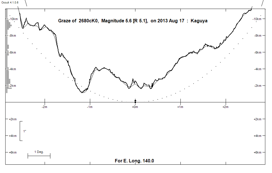
Lunar Limb Profile - near Newcastle