Predictions for Grazing Occultation of ZC 691, 2013 Aug 28 near Port Macquarie
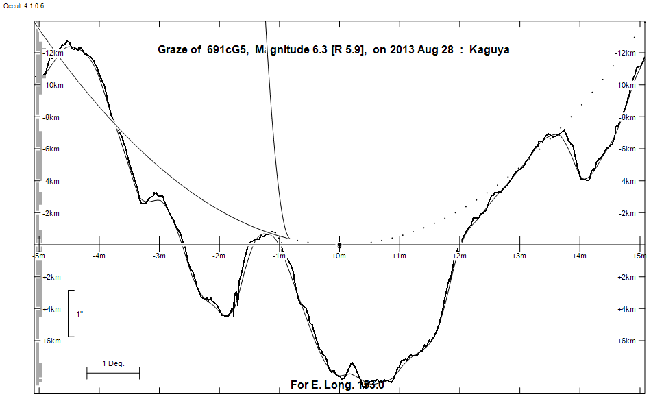
Graze profile Pt Macquarie
Grazing Occultation of     691cG5      Magnitude 6.3 [Red = 5.9]
Date: 2013 Aug 28 18h 53m,  to  2013 Aug 28 19h 44m

Nominal site altitude 50m

E. Longit.   Latitude     U.T.    Sun  Moon   TanZ   PA    AA      CA
   o  '  "    o  '  "   h  m  s   Alt Alt Az          o     o      o
 145  0  0  -33 26 17  19 15 21       34  21  1.48 170.1 179.61  -1.56S
 145 30  0  -33 15 39  19 16 35       34  20  1.46 170.2 179.72  -1.44S
 146  0  0  -33  5 14  19 17 51       35  19  1.43 170.4 179.85  -1.32S
 146 30  0  -32 55  2  19 19  8       35  18  1.41 170.5 179.98  -1.19S
 147  0  0  -32 45  4  19 20 27       36  17  1.40 170.6 180.11  -1.05S
 147 30  0  -32 35 21  19 21 47       36  16  1.38 170.8 180.25  -0.92S
 148  0  0  -32 25 52  19 23  8       36  15  1.36 170.9 180.39  -0.77S
 148 30  0  -32 16 39  19 24 30       37  15  1.34 171.1 180.54  -0.62S
 149  0  0  -32  7 42  19 25 54       37  14  1.33 171.2 180.70  -0.47S
 149 30  0  -31 59  2  19 27 19       37  13  1.31 171.4 180.86  -0.31S
 150  0  0  -31 50 38  19 28 45  -12  38  12  1.30 171.5 181.02  -0.14S
 150 30  0  -31 42 33  19 30 13  -11  38  11  1.29 171.7 181.19   0.02S
 151  0  0  -31 34 45  19 31 41  -10  38  10  1.27 171.9 181.36   0.20S
 151 30  0  -31 27 16  19 33 10  -10  38   9  1.26 172.1 181.54   0.38S
 152  0  0  -31 20  6  19 34 41   -9  39   8  1.25 172.2 181.72   0.56S
 152 30  0  -31 13 15  19 36 12   -8  39   7  1.24 172.4 181.91   0.74S
 153  0  0  -31  6 45  19 37 44   -7  39   5  1.24 172.6 182.10   0.94S
 153 30  0  -31  0 35  19 39 16   -6  39   4  1.23 172.8 182.30   1.13S
 154  0  0  -30 54 45  19 40 50   -6  39   3  1.22 173.0 182.49   1.33S
 154 30  0  -30 49 17  19 42 24   -5  39   2  1.22 173.2 182.69   1.53S
 155  0  0  -30 44 10  19 43 58   -4  40   1  1.21 173.4 182.90   1.73S

Path coordinates are referred to WGS84 (as used by GPS), with the
nominal site altitude being referenced to Mean Sea Level.

Projected diameter of star  2 meters  [Estimated]

691 is double:
  AB 6.4      0.057" 121.6 (L     4) Graze path of B 0.11 km north, and 0.1 secs later compared to A

                Librations  Long +4.21   Lat +2.63
                            P +179.60     D +2.93
      Illumination of moon  46%-
        Elongation of Moon  85
    Vertical Profile Scale  2.91 km/arcsec at mean distance of moon
   Horizontal Scale Factor  1.22 deg/min


At longitude 144.00:
Limiting Magnitudes for various telescope apertures (in cm)
      CA\Tdia   5    10    15    20    25    30    35
    -5.8      3.1   4.5   5.2   5.6   5.9   6.1   6.2
    -3.8      3.1   4.5   5.2   5.6   5.9   6.1   6.2
    -1.8      3.1   4.5   5.2   5.6   5.9   6.1   6.2
     0.2      4.9   6.3   7.1   7.5   7.9   8.1   8.3
     2.2      4.9   6.3   7.1   7.6   7.9   8.1   8.3

------------------------------------------------------------------------------
Double star catalogue details
WDS entries

  RA  Dec Name          Y1   Y2     N  PA  PA   Sep   Sep  M1    M2
04357+1953L     4      1902 1994    2 192 134   0.3   0.1  6.36       G5II-     -021-018          +19  742 N    043542.57+195254.6

------------------------------------------------
Interferometric catalogue entries

043542.57+195254.6  ADS  3316                 L     4                   HD  29104    HIP  21408         04357+1953 N
    Date       PA              Sep                  M1             M2
  1983.9283      .      .   <  0.06       .          .      .       .      .       550   3   2.0   1  Bnu1984  S
  1991.25        .      .   <  0.1        .         6.48    .       .      .       511 222   0.3   1  HIP1997e Hh
  1994.720    134.     3.5     0.065     0.002       .      .       .      .       644  70   2.0   1  Pru2002b S


------------------------------------------------------------------------------
Results of Observer Scan                                    UT
Site                              Long.   Lat.   Dist.    h  m  s
Newcastle                         151.7  -33.0   166km   19 33 49
Pt Macquarie                      152.8  -31.4    27km   19 37 13
Sydney                            151.1  -33.8   242km   19 31 53
Lunar Limb Profile - near Port Mcquarie