Predictions for Grazing Occultation of ZC 2436, 2013 Sep 12 near Naracoorte SA, Bendigo and
Canberra
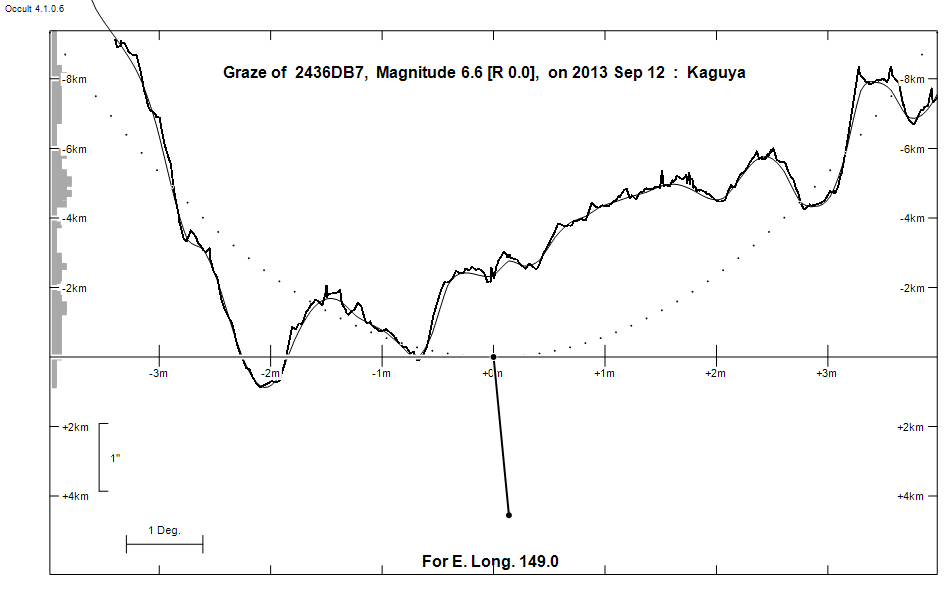
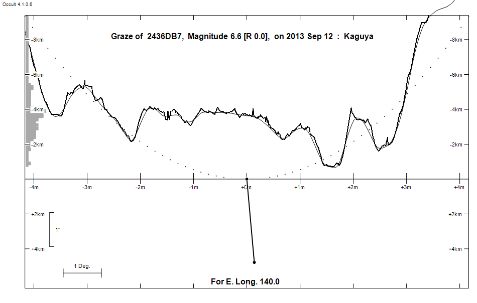
Graze profile Naracoorte | Canberra
Grazing Occultation of    2436DB7      Magnitude 6.6 [Red = 0.0]
Date: 2013 Sep 12  9h 18m,  to  2013 Sep 12  9h 58m

Nominal site altitude 50m

E. Longit.   Latitude     U.T.    Sun  Moon   TanZ   PA    AA      CA
   o  '  "    o  '  "   h  m  s   Alt Alt Az          o     o      o
 133  0  0  -37 20 35   9 18 18   -5  70 332  0.35 181.3 173.92   4.55S
 133 30  0  -37 19 40   9 19 15   -6  70 330  0.36 181.2 173.79   4.68S
 134  0  0  -37 18 34   9 20 13   -6  70 328  0.37 181.0 173.66   4.81S
 134 30  0  -37 17 18   9 21 11   -7  70 326  0.37 180.9 173.53   4.94S
 135  0  0  -37 15 53   9 22  8   -8  69 324  0.38 180.8 173.39   5.08S
 135 30  0  -37 14 17   9 23  5   -8  69 323  0.38 180.7 173.26   5.21S
 136  0  0  -37 12 32   9 24  2   -9  69 321  0.39 180.5 173.13   5.34S
 136 30  0  -37 10 37   9 24 59   -9  68 319  0.40 180.4 173.00   5.47S
 137  0  0  -37  8 32   9 25 56  -10  68 318  0.41 180.3 172.87   5.60S
 137 30  0  -37  6 17   9 26 53  -11  68 316  0.41 180.1 172.75   5.72S
 138  0  0  -37  3 52   9 27 50  -11  67 315  0.42 180.0 172.62   5.85S
 138 30  0  -37  1 18   9 28 46  -12  67 313  0.43 179.9 172.49   5.98S
 139  0  0  -36 58 34   9 29 42       66 312  0.44 179.8 172.36   6.11S
 139 30  0  -36 55 40   9 30 39       66 310  0.45 179.6 172.24   6.23S
 140  0  0  -36 52 36   9 31 35       66 309  0.46 179.5 172.11   6.35S
 140 30  0  -36 49 23   9 32 30       65 308  0.46 179.4 171.99   6.48S
 141  0  0  -36 46  1   9 33 26       65 306  0.47 179.3 171.87   6.60S
 141 30  0  -36 42 29   9 34 22       64 305  0.48 179.1 171.75   6.72S
 142  0  0  -36 38 47   9 35 17       64 304  0.49 179.0 171.63   6.84S
 142 30  0  -36 34 56   9 36 12       63 303  0.50 178.9 171.51   6.96S
 143  0  0  -36 30 55   9 37  7       63 302  0.51 178.8 171.39   7.08S
 143 30  0  -36 26 46   9 38  2       62 300  0.52 178.7 171.27   7.20S
 144  0  0  -36 22 27   9 38 56       62 299  0.53 178.6 171.16   7.31S
 144 30  0  -36 17 58   9 39 51       61 298  0.54 178.4 171.04   7.43S
 145  0  0  -36 13 21   9 40 45       61 297  0.56 178.3 170.93   7.54S
 145 30  0  -36  8 34   9 41 39       60 296  0.57 178.2 170.81   7.65S
 146  0  0  -36  3 39   9 42 32       60 295  0.58 178.1 170.70   7.76S
 146 30  0  -35 58 34   9 43 26       59 294  0.59 178.0 170.59   7.87S
 147  0  0  -35 53 20   9 44 19       59 293  0.60 177.9 170.48   7.98S
 147 30  0  -35 47 58   9 45 12       58 292  0.61 177.8 170.38   8.09S
 148  0  0  -35 42 26   9 46  5       58 291  0.63 177.7 170.27   8.20S
 148 30  0  -35 36 46   9 46 57       57 291  0.64 177.6 170.17   8.30S
 149  0  0  -35 30 57   9 47 50       57 290  0.65 177.5 170.06   8.41S
 149 30  0  -35 25  0   9 48 42       56 289  0.67 177.4 169.96   8.51S
 150  0  0  -35 18 54   9 49 33       56 288  0.68 177.3 169.86   8.61S
 150 30  0  -35 12 40   9 50 25       55 287  0.69 177.2 169.76   8.71S
 151  0  0  -35  6 17   9 51 16       55 286  0.71 177.1 169.66   8.80S
 151 30  0  -34 59 46   9 52  7       54 286  0.72 177.0 169.57   8.90S
 152  0  0  -34 53  6   9 52 58       54 285  0.73 176.9 169.47   9.00S
 152 30  0  -34 46 19   9 53 48       53 284  0.75 176.8 169.38   9.09S
 153  0  0  -34 39 23   9 54 38       53 283  0.76 176.7 169.29   9.18S
 153 30  0  -34 32 19   9 55 27       52 283  0.78 176.6 169.20   9.27S
 154  0  0  -34 25  8   9 56 17       52 282  0.79 176.5 169.11   9.36S
 154 30  0  -34 17 49   9 57  6       51 281  0.81 176.4 169.02   9.45S
 155  0  0  -34 10 22   9 57 54       50 281  0.83 176.3 168.94   9.53S

Path coordinates are referred to WGS84 (as used by GPS), with the
nominal site altitude being referenced to Mean Sea Level.

2436 is double:
  AB 6.6 7.6 4.4" 232.0 (SHJ 240) Graze path of B 5.27 km north, and 8.8 secs earlier compared to A

                Librations  Long -3.29   Lat -4.24
                            P +171.37     D -4.44
      Illumination of moon  46%+
        Elongation of Moon  86
    Vertical Profile Scale  1.95 km/arcsec at mean distance of moon
   Horizontal Scale Factor  1.42 deg/min


At longitude 144.00:
Limiting Magnitudes for various telescope apertures (in cm)
      CA\Tdia   5    10    15    20    25    30    35
     3.3      5.1   6.5   7.4   7.9   8.3   8.5   8.7
     5.3      5.9   7.4   8.2   8.8   9.1   9.4   9.7
     7.3      5.9   7.4   8.2   8.8   9.2   9.5   9.7
     9.3      5.9   7.4   8.2   8.8   9.2   9.5   9.7
    11.3      6.0   7.4   8.2   8.8   9.2   9.5   9.7

------------------------------------------------------------------------------
Double star catalogue details
WDS entries

  RA  Dec Name          Y1   Y2     N  PA  PA   Sep   Sep  M1    M2
16571-1932SHJ 240      1833 2010   54 231 232   5.8   4.4  6.59  7.59 B6V  B7V  +006-002 -074-036 -19 4471   D  165704.00-193223.5

------------------------------------------------
Interferometric catalogue entries

165703.99-193223.4  BD-19 4471                SHJ 240B                  HD 152909B   HIP  82951         16571-1932
    Date       PA              Sep                  M1             M2
  1995.6690  V 55.      .      0.0168    0.0015      .      .      0.6    0.1     2210 350         1  Rch1997  O

165704.00-193223.5  ADS 10266                 SHJ 240AB                 HD 152909    HIP  82951         16571-1932
    Date       PA              Sep                  M1             M2
  1991.25     232.3     .      4.604      .         6.643  0.007   7.753  0.018    511 222   0.3   1  HIP1997a Hh
  1991.68     232.6     .      4.698      .         6.588  0.010   7.588  0.013    530 100   1.4   1  TYC2000b Ht
  1991.68        .      .       .         .         6.626  0.015   7.697  0.016    430  90   1.4   1  TYC2000b Ht
  2000.4907   233.2     .      4.49       .          .      .       .      .                 0.7   3  WSI2001b Su
  2002.689    231.8     .      4.54       .          .      .       .      .       550  24   0.7   1  WSI2004a Su
  2003.478    231.7     .      4.56       .          .      .       .      .       550       0.7   1  WSI2004b Su

165704.00-193223.5  HR 6294                   SHJ 240A                  HD 152909    HIP  82951         16571-1932
    Date       PA              Sep                  M1             M2
  1985.515       .      .   <  0.038      .          .      .       .      .       549  22   3.6   1  McA1987a Sc


------------------------------------------------------------------------------
Results of Observer Scan                                    UT
Site                              Long.   Lat.   Dist.    h  m  s
Adelaide                          138.6  -34.9   231km    9 28 57
Bendigo                           144.3  -36.8    52km    9 39 33
Canberra                          149.2  -35.3    22km    9 48  5
Melbourne                         145.0  -37.8   173km    9 40 41
Newcastle                         151.7  -33.0   214km    9 52 29
Sydney                            151.1  -33.8   135km    9 51 23
Lunar Limb Profile - near Naracoorte
Lunar Limb Profile - near Bendigo and Canberra