Predictions for Grazing Occultation of ZC 2913, 2013 Sep 15 near Naracoorte SA, Bendigo and
Canberra
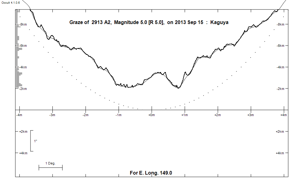
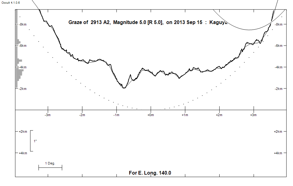
Graze profile Naracoorte | Canberra
Grazing Occultation of    2913 A2      Magnitude 5.0 [Red = 5.0]
   R2913 = 61 Sagittarii
Date: 2013 Sep 15  8h 52m,  to  2013 Sep 15  9h 29m

Nominal site altitude 50m

E. Longit.   Latitude     U.T.    Sun  Moon   TanZ   PA    AA      CA
   o  '  "    o  '  "   h  m  s   Alt Alt Az          o     o      o
 133  0  0  -37  4 17   8 51 31    1  49  69  0.87 167.7 178.79   4.79S
 133 30  0  -37  4 13   8 52 13    0  50  68  0.85 167.6 178.68   4.90S
 134  0  0  -37  4  0   8 52 55    0  50  68  0.84 167.5 178.57   5.01S
 134 30  0  -37  3 40   8 53 37   -1  51  67  0.82 167.4 178.46   5.12S
 135  0  0  -37  3 10   8 54 20   -2  51  66  0.81 167.2 178.35   5.23S
 135 30  0  -37  2 33   8 55  3   -2  52  66  0.79 167.1 178.24   5.35S
 136  0  0  -37  1 46   8 55 46   -3  52  65  0.78 167.0 178.12   5.46S
 136 30  0  -37  0 51   8 56 30   -3  53  64  0.76 166.9 178.01   5.58S
 137  0  0  -36 59 48   8 57 15   -4  53  64  0.75 166.8 177.89   5.69S
 137 30  0  -36 58 35   8 58  0   -4  54  63  0.74 166.7 177.77   5.81S
 138  0  0  -36 57 14   8 58 45   -5  54  62  0.72 166.6 177.66   5.93S
 138 30  0  -36 55 43   8 59 31   -5  55  61  0.71 166.4 177.54   6.04S
 139  0  0  -36 54  4   9  0 17   -6  55  61  0.70 166.3 177.42   6.16S
 139 30  0  -36 52 16   9  1  4   -7  56  60  0.68 166.2 177.31   6.27S
 140  0  0  -36 50 18   9  1 51   -7  56  59  0.67 166.1 177.18   6.40S
 140 30  0  -36 48 11   9  2 38   -8  57  58  0.66 166.0 177.06   6.52S
 141  0  0  -36 45 55   9  3 26   -8  57  58  0.65 165.8 176.94   6.64S
 141 30  0  -36 43 29   9  4 14   -9  58  57  0.63 165.7 176.81   6.77S
 142  0  0  -36 40 54   9  5  3   -9  58  56  0.62 165.6 176.69   6.89S
 142 30  0  -36 38 10   9  5 52  -10  59  55  0.61 165.5 176.56   7.02S
 143  0  0  -36 35 16   9  6 42  -10  59  54  0.60 165.3 176.43   7.15S
 143 30  0  -36 32 12   9  7 32  -11  60  53  0.59 165.2 176.31   7.27S
 144  0  0  -36 28 58   9  8 23  -12  60  52  0.58 165.1 176.18   7.40S
 144 30  0  -36 25 34   9  9 14       61  51  0.56 165.0 176.05   7.52S
 145  0  0  -36 22  1   9 10  5       61  50  0.55 164.8 175.92   7.66S
 145 30  0  -36 18 18   9 10 57       62  49  0.54 164.7 175.79   7.79S
 146  0  0  -36 14 24   9 11 50       62  48  0.53 164.6 175.66   7.92S
 146 30  0  -36 10 20   9 12 43       62  47  0.52 164.4 175.53   8.05S
 147  0  0  -36  6  7   9 13 36       63  46  0.51 164.3 175.39   8.18S
 147 30  0  -36  1 42   9 14 30       63  45  0.50 164.2 175.26   8.32S
 148  0  0  -35 57  8   9 15 24       64  44  0.49 164.0 175.13   8.45S
 148 30  0  -35 52 23   9 16 19       64  42  0.48 163.9 175.00   8.58S
 149  0  0  -35 47 27   9 17 14       65  41  0.47 163.8 174.87   8.71S
 149 30  0  -35 42 21   9 18 10       65  40  0.46 163.6 174.74   8.84S
 150  0  0  -35 37  4   9 19  6       66  39  0.45 163.5 174.60   8.97S
 150 30  0  -35 31 36   9 20  2       66  37  0.44 163.4 174.47   9.11S
 151  0  0  -35 25 58   9 20 59       67  36  0.43 163.2 174.34   9.24S
 151 30  0  -35 20  9   9 21 57       67  34  0.42 163.1 174.20   9.37S
 152  0  0  -35 14  9   9 22 55       67  33  0.42 163.0 174.07   9.51S
 152 30  0  -35  7 57   9 23 53       68  31  0.41 162.8 173.93   9.64S
 153  0  0  -35  1 35   9 24 52       68  30  0.40 162.7 173.80   9.78S
 153 30  0  -34 55  1   9 25 52       69  28  0.39 162.6 173.66   9.91S
 154  0  0  -34 48 17   9 26 52       69  26  0.38 162.4 173.53  10.05S
 154 30  0  -34 41 21   9 27 52       69  25  0.38 162.3 173.39  10.18S
 155  0  0  -34 34 13   9 28 53       70  23  0.37 162.2 173.26  10.31S

Path coordinates are referred to WGS84 (as used by GPS), with the
nominal site altitude being referenced to Mean Sea Level.


    C A S S I N I   R E G I O N   G R A Z E
                Librations  Long +0.80   Lat -6.86
                            P +176.06     D -6.53
      Illumination of moon  79%+
        Elongation of Moon  126
    Vertical Profile Scale  1.95 km/arcsec at mean distance of moon
   Horizontal Scale Factor  1.44 deg/min


At longitude 144.00:
Limiting Magnitudes for various telescope apertures (in cm)
      CA\Tdia   5    10    15    20    25    30    35
     3.4      4.7   6.2   7.0   7.5   7.8   8.1   8.3
     5.4      4.7   6.2   7.0   7.5   7.9   8.1   8.3
     7.4      5.1   6.6   7.4   7.9   8.2   8.5   8.7
     9.4      5.6   7.1   7.9   8.4   8.8   9.1   9.3
    11.4      5.6   7.1   7.9   8.4   8.8   9.1   9.3

------------------------------------------------------------------------------
Results of Observer Scan                                    UT
Site                              Long.   Lat.   Dist.    h  m  s
Adelaide                          138.6  -34.9   222km    8 59 40
Bendigo                           144.3  -36.8    39km    9  8 57
Canberra                          149.2  -35.3    52km    9 17 31
Melbourne                         145.0  -37.8   158km    9 10  2
Newcastle                         151.7  -33.0   253km    9 22 22
Sydney                            151.1  -33.8   171km    9 21  7
Lunar Limb Profile - near Naracoorte
Lunar Limb Profile - near Bendigo and Canberra