Predictions for Grazing Occultation of ZC 894, 2013 Sep 26, southeast of Adelaide to
Tamworth and south of Coff's Harbour, NSW
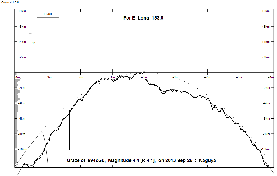
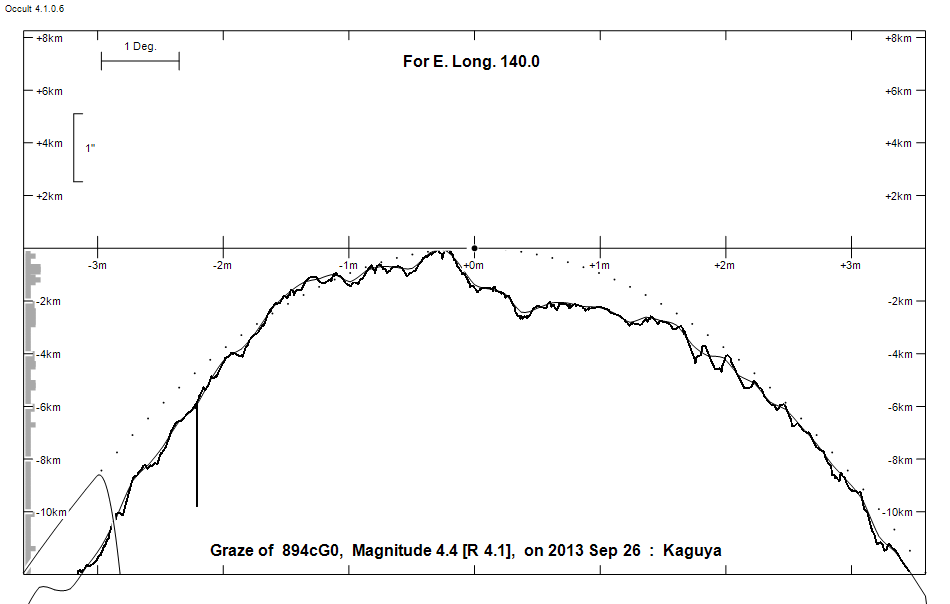
Graze profile Adelaide | Coff's Harbour
Grazing Occultation of     894cG0      Magnitude 4.4 [Red = 4.1]  v
   R894 = chi 1 Orionis
Date: 2013 Sep 26 15h 47m,  to  2013 Sep 26 15h 58m

Nominal site altitude 50m

E. Longit.   Latitude     U.T.    Sun  Moon   TanZ   PA    AA      CA
   o  '  "    o  '  "   h  m  s   Alt Alt Az          o     o      o
 138 30  0  -36 13 27  15 47 41        5  61 12.01 355.0 356.45   4.83N
 139  0  0  -36  1 36  15 47 48        5  60 10.93 355.0 356.44   4.85N
 139 30  0  -35 49 45  15 47 55        6  60 10.02 355.0 356.43   4.85N
 140  0  0  -35 37 54  15 48  3        6  60  9.24 355.0 356.42   4.86N
 140 30  0  -35 26  1  15 48 12        7  59  8.57 354.9 356.42   4.87N
 141  0  0  -35 14  9  15 48 22        7  59  7.99 354.9 356.41   4.88N
 141 30  0  -35  2 15  15 48 32        8  59  7.48 354.9 356.40   4.88N
 142  0  0  -34 50 22  15 48 42        8  58  7.03 354.9 356.40   4.89N
 142 30  0  -34 38 28  15 48 54        9  58  6.62 354.9 356.40   4.89N
 143  0  0  -34 26 35  15 49  6        9  58  6.26 354.9 356.39   4.89N
 143 30  0  -34 14 41  15 49 19       10  57  5.93 354.9 356.39   4.90N
 144  0  0  -34  2 47  15 49 32       10  57  5.63 354.9 356.39   4.90N
 144 30  0  -33 50 54  15 49 47       11  57  5.36 354.9 356.39   4.89N
 145  0  0  -33 39  0  15 50  2       11  56  5.11 354.9 356.40   4.89N
 145 30  0  -33 27  8  15 50 18       12  56  4.89 354.9 356.40   4.89N
 146  0  0  -33 15 15  15 50 34       12  56  4.68 354.9 356.41   4.88N
 146 30  0  -33  3 24  15 50 52       13  55  4.48 354.9 356.41   4.88N
 147  0  0  -32 51 33  15 51 10       13  55  4.30 355.0 356.42   4.87N
 147 30  0  -32 39 43  15 51 29       14  55  4.13 355.0 356.43   4.86N
 148  0  0  -32 27 54  15 51 48       14  54  3.98 355.0 356.44   4.85N
 148 30  0  -32 16  7  15 52  9       15  54  3.83 355.0 356.46   4.83N
 149  0  0  -32  4 20  15 52 30       15  54  3.69 355.0 356.47   4.82N
 149 30  0  -31 52 36  15 52 53       16  53  3.56 355.0 356.49   4.80N
 150  0  0  -31 40 53  15 53 16       16  53  3.44 355.0 356.51   4.78N
 150 30  0  -31 29 11  15 53 40       17  53  3.33 355.1 356.53   4.76N
 151  0  0  -31 17 32  15 54  5       17  52  3.22 355.1 356.55   4.74N
 151 30  0  -31  5 55  15 54 30       18  52  3.12 355.1 356.57   4.71N
 152  0  0  -30 54 20  15 54 57       18  52  3.02 355.1 356.60   4.69N
 152 30  0  -30 42 48  15 55 25       19  51  2.93 355.2 356.63   4.66N
 153  0  0  -30 31 19  15 55 53       19  51  2.84 355.2 356.66   4.63N
 153 30  0  -30 19 52  15 56 22       20  50  2.76 355.2 356.69   4.59N
 154  0  0  -30  8 29  15 56 53       20  50  2.68 355.3 356.73   4.56N
 154 30  0  -29 57  9  15 57 24       21  50  2.61 355.3 356.77   4.52N
 155  0  0  -29 45 52  15 57 56       22  49  2.53 355.3 356.81   4.48N

Path coordinates are referred to WGS84 (as used by GPS), with the
nominal site altitude being referenced to Mean Sea Level.

Projected diameter of star  3 meters  [CHARM/CADARS, 8 measures]

894 is variable:
       894 = khi 1 Ori, 4.38 to 4.41, V, Type RS

894 is double:
  AB 4.5 7.5 0.009" 340.9 (KNG   1) Graze path of B 0.02 km south, and 0.0 secs earlier compared to A

    C A S S I N I   R E G I O N   G R A Z E
                Librations  Long +2.43   Lat +4.57
                            P +356.57     D -4.45
      Illumination of moon  54%-
        Elongation of Moon  95
    Vertical Profile Scale  2.58 km/arcsec at mean distance of moon
   Horizontal Scale Factor  1.55 deg/min


At longitude 144.50:
Limiting Magnitudes for various telescope apertures (in cm)
      CA\Tdia   5    10    15    20    25    30    35
     0.9      3.9   5.2   5.8   6.2   6.4   6.5   6.6
     2.9      3.9   5.2   5.8   6.2   6.4   6.5   6.6
     4.9      4.6   5.9   6.6   7.0   7.2   7.3   7.4
     6.9      4.6   6.0   6.6   7.0   7.2   7.4   7.5
     8.9      4.6   6.0   6.6   7.0   7.2   7.4   7.5

------------------------------------------------------------------------------
Double star catalogue details
WDS entries

  RA  Dec Name          Y1   Y2     N  PA  PA   Sep   Sep  M1    M2
05544+2017KNG   1      1982 2002    2 326 123   0.7   0.5  4.46  7.5            -175-090                   N D  055422.97+201634.2

------------------------------------------------
Interferometric catalogue entries

055423.08+201635.1  chi 1 Ori                 KNG   1                   HD  39587    HIP  27913         05544+2017 N
    Date       PA              Sep                  M1             M2
  1975.960       .      .   <  0.033      .          .      .       .      .       517  20   3.8   1  Hrt1984  Sc
  1979.771       .      .   <  0.030      .          .      .       .      .       470       3.8   1  Hrt1984  Sc
  1980.159       .      .   <  0.030      .          .      .       .      .       470       3.8   1  Hrt1984  Sc
  1980.718       .      .   <  0.030      .          .      .       .      .       470       3.8   1  Hrt1984  Sc
  1982.       326.      .      0.65       .          .      .      3.0     .      3400       3.    1  Mcy1983  Si
  1988.165       .      .   <  0.038      .          .      .       .      .       549  22   3.6   1  McA1993  Sc
  1991.25       .       .   <  0.1        .          .              .      .       511 222   0.3   1  HIP1997e Hh
  1997.8246      .      .   <  0.036      .          .      .       .      .       501   8   3.5   1  Hor1999  S
  2001.0280      .      .   <  0.03       .          .      .       .      .       550  24   3.8   1  Msn2012x Su
  2002.161    123.22   0.12    0.4976    0.0036      .      .    s 7.70   0.15    1635 290   9.8   1  Kng2002  A


------------------------------------------------
AAVSO Variable star entry

       Variable identifier           Type        Max    Min  Ph  Epoch         Period
       khi 1 Ori                     RS          4.38   4.41 V
------------------------------------------------------------------------------
Results of Observer Scan                                    UT
Site                              Long.   Lat.   Dist.    h  m  s
Adelaide                          138.6  -34.9   127km   15 47 42
Bendigo                           144.3  -36.8   287km   15 49 42
Brisbane                          153.1  -27.5   310km   15 55 56
Canberra                          149.2  -35.3   327km   15 52 37
Newcastle                         151.7  -33.0   195km   15 54 42
Pt Macquarie                      152.8  -31.4    83km   15 55 43
Sydney                            151.1  -33.8   258km   15 54  8
Lunar Limb Profile - near Adelaide
Lunar Limb Profile - near Coff's Harbour