Predictions for Grazing Occultation of ZC 2876, 2013 Oct 12, near Brisbane
Graze profile Brisbane
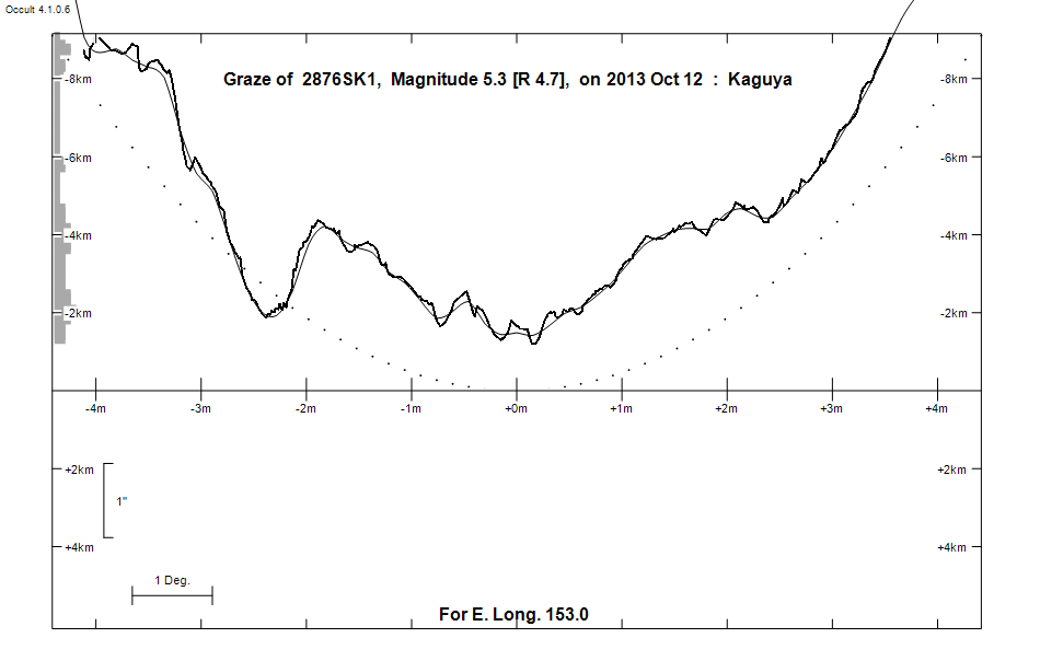
Grazing Occultation of    2876SK1      Magnitude 5.3 [Red = 4.7]  s
   R2876 = 54 Sagittarii
Date: 2013 Oct 12  7h 51m,  to  2013 Oct 12  8h 40m

Nominal site altitude 50m

E. Longit.   Latitude     U.T.    Sun  Moon   TanZ   PA    AA      CA
   o  '  "    o  '  "   h  m  s   Alt Alt Az          o     o      o
 146 30  0  -29 11 44   8 19 20    0  77  13  0.23 162.7 172.12   7.99S
 147  0  0  -29  3 40   8 20 30   -1  77  10  0.23 162.5 171.98   8.14S
 147 30  0  -28 55 23   8 21 40   -2  77   6  0.22 162.4 171.83   8.29S
 148  0  0  -28 46 54   8 22 50   -3  78   3  0.22 162.2 171.68   8.44S
 148 30  0  -28 38 13   8 24  1   -3  78 359  0.22 162.1 171.53   8.58S
 149  0  0  -28 29 18   8 25 12   -4  78 355  0.21 161.9 171.39   8.73S
 149 30  0  -28 20 12   8 26 24   -5  78 352  0.21 161.8 171.24   8.87S
 150  0  0  -28 10 52   8 27 36   -5  78 348  0.21 161.6 171.10   9.02S
 150 30  0  -28  1 21   8 28 48   -6  78 344  0.21 161.5 170.96   9.16S
 151  0  0  -27 51 37   8 30  1   -7  78 340  0.21 161.4 170.82   9.30S
 151 30  0  -27 41 40   8 31 14   -8  78 337  0.22 161.2 170.68   9.44S
 152  0  0  -27 31 32   8 32 28   -8  78 333  0.22 161.1 170.54   9.57S
 152 30  0  -27 21 11   8 33 41   -9  77 329  0.22 160.9 170.41   9.71S
 153  0  0  -27 10 38   8 34 55  -10  77 326  0.23 160.8 170.28   9.84S
 153 30  0  -26 59 53   8 36 10  -11  77 322  0.23 160.7 170.15   9.97S
 154  0  0  -26 48 56   8 37 24  -11  77 319  0.24 160.6 170.02  10.10S
 154 30  0  -26 37 47   8 38 39       76 316  0.24 160.4 169.89  10.22S
 155  0  0  -26 26 26   8 39 54       76 313  0.25 160.3 169.77  10.35S

Path coordinates are referred to WGS84 (as used by GPS), with the
nominal site altitude being referenced to Mean Sea Level.

Projected diameter of star  3 meters  [Estimated]

2876 is variable:
      2876 = NSV 12275, 5.28 to 5.36, V

2876 is triple:
  AC 5.4 7.7 45"  42.0 (HJ  599) Graze path of C 46.79 km south, and 104.8 secs later compared to A
  AB 5.4 12.6 71" 273.0 (HJ  599) Graze path of B 46.91 km south, and 180.1 secs earlier compared to A

    C A S S I N I   R E G I O N   G R A Z E
                Librations  Long +1.28   Lat -6.81
                            P +172.69     D -6.34
      Illumination of moon  55%+
        Elongation of Moon  95
    Vertical Profile Scale  1.91 km/arcsec at mean distance of moon
   Horizontal Scale Factor  1.31 deg/min


At longitude 144.00:
Limiting Magnitudes for various telescope apertures (in cm)
      CA\Tdia   5    10    15    20    25    30    35
     3.2      3.1   4.6   5.4   5.9   6.2   6.4   6.6
     5.2      3.5   5.0   5.7   6.2   6.6   6.8   7.0
     7.2      3.5   5.0   5.7   6.2   6.6   6.8   7.0
     9.2      3.5   5.0   5.7   6.2   6.6   6.8   7.0
    11.2      3.5   5.0   5.7   6.2   6.6   6.8   7.0

------------------------------------------------------------------------------
Double star catalogue details
WDS entries

  RA  Dec Name          Y1   Y2     N  PA  PA   Sep   Sep  M1    M2
19407-1618HJ  599AB    1828 2009    7 273 279  15.0  45.2  5.42 12.6  K2III F8V +071-048          -16 5399 N    194043.34-161735.3
19407-1618HJ  599AC    1827 2010   33  40  42  40.0  45.3  5.42  7.65           +069-051 +077-054 -16 5400 N D  194043.34-161735.3
19407-1618ANT   6AD    2009 2009    1 252 252  56.8  56.8  5.42 13.9            +069-051 -026-010               194043.34-161735.3
19409-1619BU 1287      1899 1936    4 144 143   1.1   1.2 10.8  11.5                                           !194054.  -1619

------------------------------------------------
Interferometric catalogue entries

194043.34-161735.3  ADS 12767                 HJ  599A                  HD 185644    HIP  96808         19407-1618 N
    Date       PA              Sep                  M1             M2
  1980.723       .      .   <  0.030      .          .      .       .      .       470       3.8   1  Hrt1984  Sc
  1985.521       .      .   <  0.038      .          .      .       .      .       549  22   3.6   1  McA1987a Sc
  1991.25        .      .   <  0.1        .         5.46    .       .      .       511 222   0.3   1  HIP1997e Hh

194043.34-161735.3  ADS 12767                 HJ  599AC                 HD 185644    HIP  96808         19407-1618 N
    Date       PA              Sep                  M1             M2
  1991.62      42.0     .     45.643      .         5.421  0.009   7.649  0.012    530 100   1.4   1  TYC2000b Ht
  1991.62        .      .       .         .         6.731  0.015   8.472  0.017    430  90   1.4   1  TYC2000b Ht
  2003.628     41.5     .     44.72       .          .      .       .      .       550       0.7   1  WSI2004b Su


------------------------------------------------
AAVSO Variable star entry

       Variable identifier           Type        Max    Min  Ph  Epoch         Period
       NSV 12275                                 5.28   5.36 V
------------------------------------------------------------------------------
Results of Observer Scan                                    UT
Site                              Long.   Lat.   Dist.    h  m  s
Brisbane                          153.1  -27.5    32km    8 35  3
Bundaberg                         152.3  -24.8   270km    8 33 17
Lunar Limb Profile - near Brisbane