Predictions for Grazing Occultation of ZC 3444, 2013 Oct 16, near Adelaide to north of
Grafton, NSW
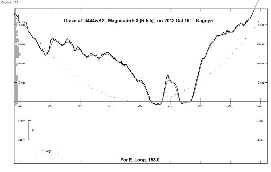
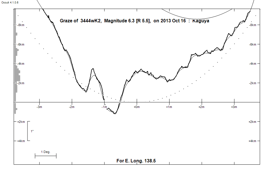
Graze profile Adelaide | Grafton
Grazing Occultation of    3444wK2      Magnitude 6.3 [Red = 5.5]
Date: 2013 Oct 16  9h 47m,  to  2013 Oct 16 10h 22m

Nominal site altitude 50m

E. Longit.   Latitude     U.T.    Sun  Moon   TanZ   PA    AA      CA
   o  '  "    o  '  "   h  m  s   Alt Alt Az          o     o      o
 133  0  0  -37  1  2   9 47  7   -5  33  60  1.52 154.2 178.50   9.35S
 133 30  0  -36 52 51   9 47 37   -6  34  59  1.49 154.1 178.40   9.45S
 134  0  0  -36 44 32   9 48  7   -6  34  59  1.46 154.0 178.30   9.56S
 134 30  0  -36 36  4   9 48 38   -7  35  58  1.44 153.9 178.19   9.66S
 135  0  0  -36 27 27   9 49 10   -7  35  58  1.41 153.8 178.08   9.77S
 135 30  0  -36 18 41   9 49 43   -8  36  57  1.38 153.7 177.98   9.87S
 136  0  0  -36  9 46   9 50 16   -8  36  57  1.36 153.6 177.87   9.98S
 136 30  0  -36  0 41   9 50 50   -9  37  56  1.33 153.5 177.76  10.09S
 137  0  0  -35 51 27   9 51 24   -9  37  56  1.31 153.4 177.65  10.20S
 137 30  0  -35 42  4   9 51 59  -10  38  55  1.28 153.3 177.54  10.31S
 138  0  0  -35 32 31   9 52 35  -10  38  55  1.26 153.2 177.43  10.42S
 138 30  0  -35 22 48   9 53 12  -11  39  54  1.23 153.1 177.32  10.53S
 139  0  0  -35 12 56   9 53 50  -12  40  54  1.21 153.0 177.21  10.64S
 139 30  0  -35  2 53   9 54 28       40  53  1.19 152.8 177.10  10.75S
 140  0  0  -34 52 41   9 55  7       41  53  1.17 152.7 176.98  10.86S
 140 30  0  -34 42 18   9 55 47       41  52  1.14 152.6 176.87  10.98S
 141  0  0  -34 31 46   9 56 27       42  52  1.12 152.5 176.76  11.09S
 141 30  0  -34 21  3   9 57  9       42  51  1.10 152.4 176.64  11.20S
 142  0  0  -34 10  9   9 57 51       43  51  1.08 152.3 176.53  11.32S
 142 30  0  -33 59  5   9 58 34       43  50  1.06 152.2 176.41  11.43S
 143  0  0  -33 47 50   9 59 18       44  49  1.04 152.0 176.30  11.55S
 143 30  0  -33 36 25  10  0  3       44  49  1.02 151.9 176.18  11.66S
 144  0  0  -33 24 49  10  0 49       45  48  1.00 151.8 176.07  11.78S
 144 30  0  -33 13  1  10  1 35       46  48  0.98 151.7 175.95  11.89S
 145  0  0  -33  1  3  10  2 23       46  47  0.96 151.6 175.83  12.01S
 145 30  0  -32 48 54  10  3 11       47  46  0.94 151.5 175.72  12.13S
 146  0  0  -32 36 33  10  4  1       47  46  0.92 151.4 175.61  12.23S
 146 30  0  -32 24  1  10  4 51       48  45  0.90 151.2 175.49  12.35S
 147  0  0  -32 11 18  10  5 42       48  44  0.89 151.1 175.38  12.47S
 147 30  0  -31 58 23  10  6 34       49  44  0.87 151.0 175.26  12.58S
 148  0  0  -31 45 16  10  7 28       50  43  0.85 150.9 175.14  12.70S
 148 30  0  -31 31 58  10  8 22       50  42  0.83 150.8 175.03  12.81S
 149  0  0  -31 18 29  10  9 17       51  41  0.82 150.7 174.91  12.93S
 149 30  0  -31  4 47  10 10 14       51  40  0.80 150.5 174.80  13.04S
 150  0  0  -30 50 54  10 11 11       52  40  0.78 150.4 174.68  13.16S
 150 30  0  -30 36 49  10 12  9       53  39  0.77 150.3 174.57  13.27S
 151  0  0  -30 22 31  10 13  9       53  38  0.75 150.2 174.45  13.39S
 151 30  0  -30  8  2  10 14 10       54  37  0.73 150.1 174.34  13.50S
 152  0  0  -29 53 21  10 15 11       54  36  0.72 150.0 174.23  13.61S
 152 30  0  -29 38 28  10 16 14       55  35  0.70 149.9 174.12  13.72S
 153  0  0  -29 23 24  10 17 18       55  34  0.69 149.8 174.01  13.83S
 153 30  0  -29  8  7  10 18 23       56  33  0.67 149.6 173.90  13.94S
 154  0  0  -28 52 38  10 19 30       57  32  0.66 149.5 173.79  14.05S
 154 30  0  -28 36 57  10 20 37       57  31  0.64 149.4 173.68  14.15S
 155  0  0  -28 21  5  10 21 46       58  30  0.63 149.3 173.58  14.26S

Path coordinates are referred to WGS84 (as used by GPS), with the
nominal site altitude being referenced to Mean Sea Level.

Projected diameter of star  5 meters  [Estimated]

3444 is double:
  AB 6.3 10.5 39" 148.9 (HJ 3189) Graze path of B 79.15 km north, and 4.8 secs later compared to A

    C A S S I N I   R E G I O N   G R A Z E
                Librations  Long +5.27   Lat -5.26
                            P +175.61     D -4.62
      Illumination of moon  93%+
        Elongation of Moon  148
    Vertical Profile Scale  2.01 km/arcsec at mean distance of moon
   Horizontal Scale Factor  1.47 deg/min


At longitude 144.00:
Limiting Magnitudes for various telescope apertures (in cm)
      CA\Tdia   5    10    15    20    25    30    35
     7.8      4.5   5.9   6.7   7.2   7.5   7.7   7.9
     9.8      4.5   5.9   6.7   7.2   7.5   7.7   7.9
    11.8      4.5   5.9   6.7   7.2   7.5   7.8   7.9
    13.8      4.9   6.3   7.1   7.6   7.9   8.1   8.3
    15.8      5.4   6.8   7.6   8.1   8.4   8.7   8.8

------------------------------------------------------------------------------
Double star catalogue details
WDS entries

  RA  Dec Name          Y1   Y2     N  PA  PA   Sep   Sep  M1    M2
23235+0017HJ 3189      1831 2005    9 130 148  50.0  39.2  6.31 10.5  K2        +070+013          -00 4509   D  232331.90+001728.7

------------------------------------------------
Interferometric catalogue entries

232331.90+001728.7  .                         HJ 3189                   BD-00 4509   HIP 115476         23235+0017
    Date       PA              Sep                  M1             M2
  1991.25        .      .   <  0.1        .         6.44    .       .      .       511 222   0.3   1  HIP1997e Hh


------------------------------------------------------------------------------
Results of Observer Scan                                    UT
Site                              Long.   Lat.   Dist.    h  m  s
Brisbane                          153.1  -27.5   182km   10 17 25
Lunar Limb Profile - near Adelaide
Lunar Limb Profile - near Grafton