Predictions for Grazing Occultation of ZC 3272, 2013 Nov 11, north of Adelaide to
Maryborough
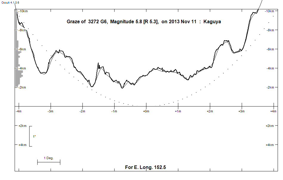
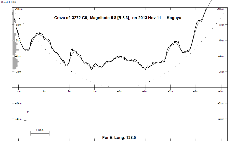
Graze profile Adelaide | Maryborough
Grazing Occultation of    3272 G6      Magnitude 5.8 [Red = 5.3]
   R3272 = 44 Aquarii
Date: 2013 Nov 11  9h 46m,  to  2013 Nov 11 10h 45m

Nominal site altitude 50m

E. Longit.   Latitude     U.T.    Sun  Moon   TanZ   PA    AA      CA
   o  '  "    o  '  "   h  m  s   Alt Alt Az          o     o      o
 133  0  0  -36 43 31   9 45 45    0  59   8  0.61 151.6 173.43   8.69S
 133 30  0  -36 28 47   9 46 52   -1  59   7  0.60 151.5 173.34   8.78S
 134  0  0  -36 13 52   9 48  0   -1  59   5  0.60 151.4 173.25   8.88S
 134 30  0  -35 58 45   9 49  8   -2  59   4  0.59 151.3 173.16   8.97S
 135  0  0  -35 43 28   9 50 18   -3  60   2  0.58 151.3 173.07   9.05S
 135 30  0  -35 27 59   9 51 28   -3  60   1  0.58 151.2 172.98   9.14S
 136  0  0  -35 12 20   9 52 39   -4  60 359  0.57 151.1 172.90   9.22S
 136 30  0  -34 56 29   9 53 51   -5  61 358  0.57 151.0 172.82   9.31S
 137  0  0  -34 40 29   9 55  4   -5  61 356  0.56 150.9 172.74   9.39S
 137 30  0  -34 24 17   9 56 18   -6  61 354  0.55 150.8 172.66   9.46S
 138  0  0  -34  7 56   9 57 32   -7  61 352  0.55 150.8 172.59   9.54S
 138 30  0  -33 51 24   9 58 48   -8  61 351  0.55 150.7 172.51   9.61S
 139  0  0  -33 34 43  10  0  4   -8  61 349  0.54 150.6 172.44   9.68S
 139 30  0  -33 17 52  10  1 21   -9  62 347  0.54 150.6 172.38   9.75S
 140  0  0  -33  0 52  10  2 39  -10  62 345  0.54 150.5 172.31   9.81S
 140 30  0  -32 43 43  10  3 57  -11  62 343  0.54 150.4 172.25   9.87S
 141  0  0  -32 26 25  10  5 17  -11  62 342  0.53 150.4 172.20   9.93S
 141 30  0  -32  9  0  10  6 36       62 340  0.53 150.3 172.14   9.98S
 142  0  0  -31 51 26  10  7 57       62 338  0.53 150.3 172.09  10.03S
 142 30  0  -31 33 45  10  9 18       62 336  0.53 150.2 172.05  10.08S
 143  0  0  -31 15 57  10 10 40       62 334  0.53 150.2 172.00  10.12S
 143 30  0  -30 58  2  10 12  2       62 332  0.54 150.1 171.97  10.16S
 144  0  0  -30 40  2  10 13 25       62 330  0.54 150.1 171.93  10.19S
 144 30  0  -30 21 56  10 14 49       62 328  0.54 150.1 171.90  10.22S
 145  0  0  -30  3 44  10 16 13       61 327  0.54 150.1 171.87  10.25S
 145 30  0  -29 45 28  10 17 37       61 325  0.55 150.0 171.85  10.27S
 146  0  0  -29 27  8  10 19  2       61 323  0.55 150.0 171.83  10.29S
 146 30  0  -29  8 45  10 20 27       61 321  0.56 150.0 171.82  10.30S
 147  0  0  -28 50 18  10 21 52       61 319  0.56 150.0 171.81  10.31S
 147 30  0  -28 31 50  10 23 17       60 317  0.57 150.0 171.81  10.32S
 148  0  0  -28 13 19  10 24 43       60 316  0.58 150.0 171.81  10.32S
 148 30  0  -27 54 48  10 26  9       60 314  0.58 150.0 171.81  10.31S
 149  0  0  -27 36 16  10 27 35       59 312  0.59 150.0 171.82  10.30S
 149 30  0  -27 17 44  10 29  1       59 311  0.60 150.0 171.83  10.29S
 150  0  0  -26 59 12  10 30 27       59 309  0.61 150.0 171.85  10.27S
 150 30  0  -26 40 42  10 31 53       58 308  0.62 150.1 171.87  10.25S
 151  0  0  -26 22 14  10 33 18       58 306  0.63 150.1 171.90  10.22S
 151 30  0  -26  3 49  10 34 44       57 305  0.64 150.1 171.93  10.19S
 152  0  0  -25 45 26  10 36  9       57 303  0.65 150.1 171.97  10.15S
 152 30  0  -25 27  8  10 37 34       56 302  0.66 150.2 172.01  10.11S
 153  0  0  -25  8 54  10 38 59       56 300  0.68 150.2 172.05  10.07S
 153 30  0  -24 50 45  10 40 23       55 299  0.69 150.3 172.10  10.02S
 154  0  0  -24 32 41  10 41 47       55 298  0.70 150.3 172.15   9.97S
 154 30  0  -24 14 43  10 43 10       54 297  0.72 150.4 172.21   9.91S
 155  0  0  -23 56 52  10 44 33       54 295  0.73 150.5 172.27   9.85S

Path coordinates are referred to WGS84 (as used by GPS), with the
nominal site altitude being referenced to Mean Sea Level.

Projected diameter of star  2 meters  [Estimated]


                Librations  Long +4.98   Lat -6.54
                            P +171.38     D -5.52
      Illumination of moon  63%+
        Elongation of Moon  105
    Vertical Profile Scale  2.12 km/arcsec at mean distance of moon
   Horizontal Scale Factor  1.36 deg/min


At longitude 144.00:
Limiting Magnitudes for various telescope apertures (in cm)
      CA\Tdia   5    10    15    20    25    30    35
     6.2      5.8   7.2   8.0   8.6   9.0   9.2   9.4
     8.2      5.8   7.2   8.1   8.6   9.0   9.3   9.5
    10.2      5.8   7.3   8.1   8.6   9.0   9.3   9.5
    12.2      5.8   7.3   8.1   8.6   9.0   9.3   9.5
    14.2      5.8   7.3   8.1   8.6   9.0   9.3   9.5

------------------------------------------------------------------------------
Results of Observer Scan                                    UT
Site                              Long.   Lat.   Dist.    h  m  s
Adelaide                          138.6  -34.9   102km    9 59  3
Brisbane                          153.1  -27.5   216km   10 39  7
Bundaberg                         152.3  -24.8    70km   10 37  6
Lunar Limb Profile - north of Adelaide
Lunar Limb Profile - near Maryborough