Predictions for Grazing Occultation of ZC 2065, 2013 Nov 30, near Brisbane
Graze profile Brisbane
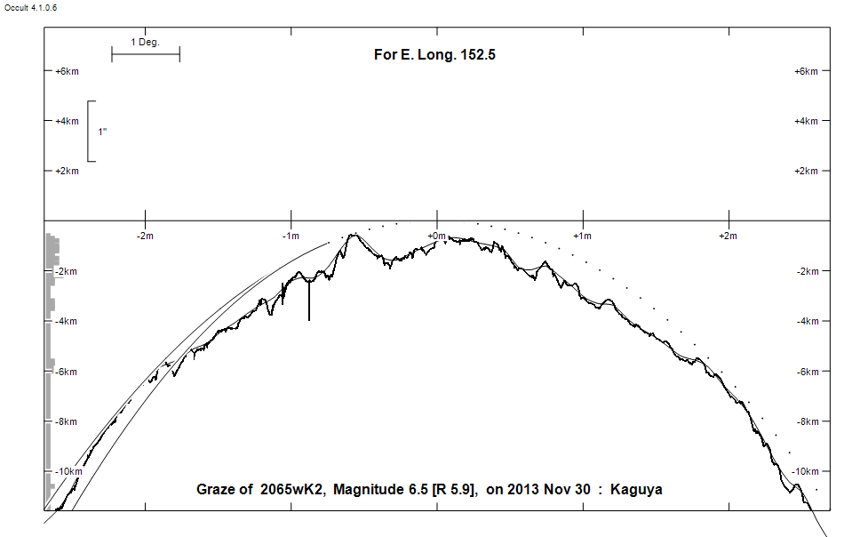
Grazing Occultation of    2065wK2      Magnitude 6.5 [Red = 5.9]
Date: 2013 Nov 30 17h 35m,  to  2013 Nov 30 17h 36m

Nominal site altitude 50m

E. Longit.   Latitude     U.T.    Sun  Moon   TanZ   PA    AA      CA
   o  '  "    o  '  "   h  m  s   Alt Alt Az          o     o      o
 146 30  0  -25 28 15  17 35 19        0 105 99.00  17.6 357.44   2.30N
 147  0  0  -25 35 34  17 35 17        1 105 99.00  17.7 357.49   2.25N
 147 30  0  -25 42 59  17 35 17        1 104 59.03  17.7 357.55   2.19N
 148  0  0  -25 50 32  17 35 17        1 104 39.85  17.8 357.61   2.13N
 148 30  0  -25 58 11  17 35 17        2 104 30.04  17.8 357.66   2.08N
 149  0  0  -26  5 57  17 35 18        2 104 24.09  17.9 357.72   2.02N
 149 30  0  -26 13 49  17 35 19        3 104 20.09  18.0 357.77   1.97N
 150  0  0  -26 21 49  17 35 22        3 103 17.22  18.0 357.83   1.91N
 150 30  0  -26 29 55  17 35 24        4 103 15.05  18.1 357.89   1.85N
 151  0  0  -26 38  9  17 35 27        4 103 13.37  18.1 357.94   1.80N
 151 30  0  -26 46 29  17 35 31        5 103 12.01  18.2 358.00   1.74N
 152  0  0  -26 54 57  17 35 35        5 102 10.90  18.2 358.06   1.68N
 152 30  0  -27  3 31  17 35 40        6 102  9.98  18.3 358.11   1.63N
 153  0  0  -27 12 13  17 35 46        6 102  9.19  18.3 358.17   1.57N
 153 30  0  -27 21  2  17 35 52        7 102  8.52  18.4 358.23   1.51N
 154  0  0  -27 29 58  17 35 58        7 101  7.93  18.5 358.28   1.46N
 154 30  0  -27 39  2  17 36  6        8 101  7.42  18.5 358.34   1.40N
 155  0  0  -27 48 13  17 36 13        8 101  6.97  18.6 358.40   1.34N

Path coordinates are referred to WGS84 (as used by GPS), with the
nominal site altitude being referenced to Mean Sea Level.

Projected diameter of star  3 meters  [Estimated]

2065 is double:
  AB 6.6 10.0 42"  46.4 (HJ  546) Graze path of B 91.68 km south, and 32.6 secs later compared to A

                Librations  Long -5.29   Lat -0.80
                            P +358.05     D +1.25
      Illumination of moon  7%-
        Elongation of Moon  30
    Vertical Profile Scale  2.41 km/arcsec at mean distance of moon
   Horizontal Scale Factor  2.18 deg/min


At longitude 151.00:
Limiting Magnitudes for various telescope apertures (in cm)
      CA\Tdia   5    10    15    20    25    30    35
    -2.2      5.4   6.9   7.7   8.2   8.6   8.9   9.1
    -0.2      5.9   7.4   8.2   8.8   9.2   9.6   9.8
     1.8      5.9   7.4   8.3   8.8   9.3   9.6   9.8
     3.8      6.0   7.4   8.3   8.9   9.3   9.6   9.9
     5.8      6.0   7.5   8.3   8.9   9.3   9.6   9.9

------------------------------------------------------------------------------
Double star catalogue details
WDS entries

  RA  Dec Name          Y1   Y2     N  PA  PA   Sep   Sep  M1    M2
14253-1321HJ  546      1902 2003    9  42  46  39.4  41.6  6.6  10.0  K2III     -056+003          -12 4042 N D  142517.63-132111.4

------------------------------------------------
Interferometric catalogue entries

142517.63-132111.4  .                         HJ  546                   BD-12 4042   HIP  70501         14253-1321 N
    Date       PA              Sep                  M1             M2
  1991.25        .      .   <  0.1        .         6.66    .       .      .       511 222   0.3   1  HIP1997e Hh
  2003.251     45.7     .     41.57       .          .      .       .      .       550       0.7   1  WSI2004b Su


------------------------------------------------------------------------------
Results of Observer Scan                                    UT
Site                              Long.   Lat.   Dist.    h  m  s
Brisbane                          153.1  -27.5    26km   17 35 46
Bundaberg                         152.3  -24.8   234km   17 35 38
Lunar Limb Profile - Brisbane