Predictions for Grazing Occultation of ZC 2658, 2013 Apr 29
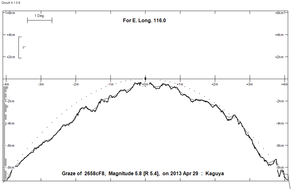
Graze profile
Grazing Occultation of    2658cF8      Magnitude 5.8 [Red = 5.4]  V
   R2658 = Y Sagittarii
Date: 2013 Apr 29 21h 28m,  to  2013 Apr 29 21h 47m

Nominal site altitude 50m

E. Longit.   Latitude     U.T.    Sun  Moon   TanZ   PA    AA      CA
   o  '  "    o  '  "   h  m  s   Alt Alt Az          o     o      o
 112  0  0  -31 25 57  21 27 59       71 306  0.35 348.2 349.44   6.64N
 112 30  0  -31 17 53  21 29 14       70 304  0.36 348.1 349.32   6.77N
 113  0  0  -31  9 38  21 30 29       70 302  0.37 348.0 349.19   6.89N
 113 30  0  -31  1 11  21 31 43       69 301  0.38 347.9 349.07   7.01N
 114  0  0  -30 52 34  21 32 57       69 299  0.39 347.8 348.95   7.13N
 114 30  0  -30 43 46  21 34 11       68 297  0.40 347.6 348.84   7.25N
 115  0  0  -30 34 48  21 35 25       67 296  0.41 347.5 348.72   7.36N
 115 30  0  -30 25 39  21 36 39       67 295  0.43 347.4 348.61   7.48N
 116  0  0  -30 16 20  21 37 52       66 293  0.44 347.3 348.50   7.59N
 116 30  0  -30  6 50  21 39  4       66 292  0.45 347.2 348.39   7.69N
 117  0  0  -29 57 11  21 40 17       65 291  0.46 347.1 348.29   7.80N
 117 30  0  -29 47 21  21 41 29       65 289  0.48 347.0 348.18   7.90N
 118  0  0  -29 37 22  21 42 41  -12  64 288  0.49 346.9 348.08   8.00N
 118 30  0  -29 27 13  21 43 52  -11  63 287  0.50 346.8 347.98   8.10N
 119  0  0  -29 16 55  21 45  3  -11  63 286  0.52 346.7 347.89   8.20N
 119 30  0  -29  6 27  21 46 14  -10  62 285  0.53 346.6 347.79   8.29N
 120  0  0  -28 55 50  21 47 24   -9  61 284  0.54 346.5 347.70   8.38N

Path coordinates are referred to WGS84 (as used by GPS), with the
nominal site altitude being referenced to Mean Sea Level.

Projected diameter of star  2 meters  [CHARM/CADARS, 2 measures]

2658 is variable:
      2658 = Y Sgr, 5.25 to 6.24, V, Type DCEP, Period 5.77335 days, Phase 73 %

2658 is double:
  This next pair is not confirmed
  ** 6.2 6.2 0.050" 350.0** (OCc1542) Graze path of ? 0.10 km south, and 0.0 secs later compared to the primary

                Librations  Long +2.10   Lat -5.36
                            P +348.25     D +5.09
      Illumination of moon  78%-
        Elongation of Moon  124
    Vertical Profile Scale  1.92 km/arcsec at mean distance of moon
   Horizontal Scale Factor  1.42 deg/min


At longitude 116.00:
Limiting Magnitudes for various telescope apertures (in cm)
      CA\Tdia   5    10    15    20    25    30    35
     3.6      4.8   6.2   7.0   7.5   7.9   8.2   8.4
     5.6      4.8   6.2   7.0   7.5   7.9   8.2   8.4
     7.6      5.4   6.8   7.6   8.2   8.5   8.8   9.0
     9.6      5.7   7.1   7.9   8.5   8.8   9.1   9.3
    11.6      5.7   7.1   8.0   8.5   8.9   9.1   9.3

------------------------------------------------------------------------------
Double star catalogue details
Interferometric catalogue entries

182122.99-185135.9  HR 6863                   Y Sgr                     HD 168608    HIP  89968         18214-1852
    Date       PA              Sep                  M1             M2
  1975.634       .      .   <  0.027      .          .      .       .      .       540  20   5.1   1  Bla1977a S
  1989.3123      .      .   <  0.035      .          .      .       .      .       549  22   4.0   1  Msn1999b Sc
  1990.3469      .      .   <  0.035      .          .      .       .      .       549  22   4.0   1  Msn1999b Sc
  1991.25        .      .   S   .         .         5.76    .       .      .       511       0.3   1  HIP1997h Hh
  1995.3168      .      .   <  0.055      .          .      .       .      .       549  22   2.5   1  Msn1999b Sc
  1996.5370      .      .   <  0.055      .          .      .       .      .       549  22   2.5   1  Msn1999b Sc


------------------------------------------------
AAVSO Variable star entry

       Variable identifier           Type        Max    Min  Ph  Epoch         Period
       Y Sgr                         DCEP        5.25   6.24 V 2440762.3800     5.77335
------------------------------------------------------------------------------
Results of Observer Scan                                    UT
Site                              Long.   Lat.   Dist.    h  m  s
Perth                             115.9  -32.0   170km   21 37 30
Lunar Limb Profile