Predictions for Grazing Occultation of ZC 2065, 2014 Jul 7, N of Rockhampton, Qld.
Graze profile Rockhampton
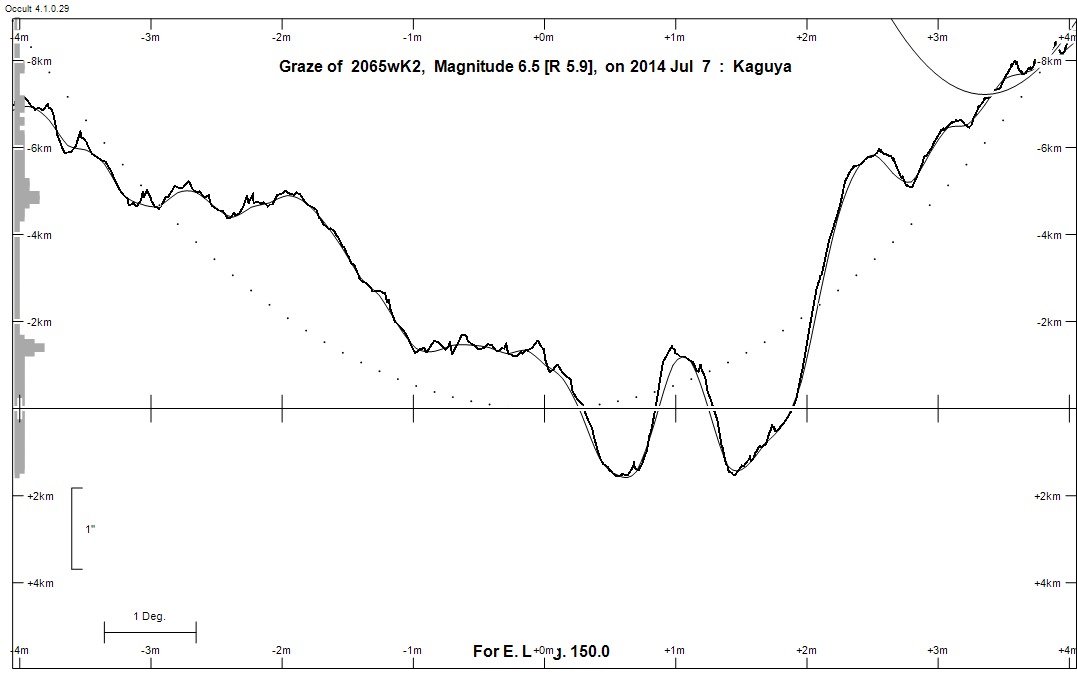
Grazing Occultation of    2065wK2      Magnitude 6.5 [Red = 5.9]
Date: 2014 Jul 07 12h  4m,  to  2014 Jul 07 12h 43m

Nominal site altitude 100m

E. Longit.   Latitude     U.T.    Sun  Moon   TanZ   PA    AA      CA
   o  '  "    o  '  "   h  m  s   Alt Alt Az          o     o      o
 133  0  0  -20 50 24  12  4 17       67 285  0.43 199.0 178.86   0.17S
 133 30  0  -20 56 29  12  5 26       66 284  0.44 198.8 178.68   0.35S
 134  0  0  -21  2 19  12  6 34       65 284  0.46 198.6 178.49   0.54S
 134 30  0  -21  7 56  12  7 41       65 283  0.47 198.4 178.31   0.72S
 135  0  0  -21 13 20  12  8 48       64 283  0.49 198.3 178.12   0.91S
 135 30  0  -21 18 31  12  9 53       63 282  0.50 198.1 177.94   1.09S
 136  0  0  -21 23 28  12 10 58       63 282  0.52 197.9 177.76   1.27S
 136 30  0  -21 28 12  12 12  3       62 282  0.54 197.7 177.58   1.45S
 137  0  0  -21 32 44  12 13  6       61 281  0.55 197.5 177.40   1.63S
 137 30  0  -21 37  3  12 14  9       60 281  0.57 197.4 177.23   1.80S
 138  0  0  -21 41  9  12 15 10       60 280  0.58 197.2 177.05   1.98S
 138 30  0  -21 45  2  12 16 11       59 280  0.60 197.0 176.88   2.15S
 139  0  0  -21 48 44  12 17 12       58 280  0.62 196.8 176.70   2.32S
 139 30  0  -21 52 13  12 18 11       58 279  0.63 196.7 176.53   2.50S
 140  0  0  -21 55 30  12 19 10       57 279  0.65 196.5 176.36   2.66S
 140 30  0  -21 58 35  12 20  8       56 279  0.67 196.3 176.20   2.83S
 141  0  0  -22  1 29  12 21  5       56 278  0.69 196.2 176.03   3.00S
 141 30  0  -22  4 11  12 22  1       55 278  0.70 196.0 175.87   3.16S
 142  0  0  -22  6 41  12 22 57       54 278  0.72 195.8 175.71   3.32S
 142 30  0  -22  9  0  12 23 52       53 277  0.74 195.7 175.55   3.48S
 143  0  0  -22 11  8  12 24 46       53 277  0.76 195.5 175.39   3.64S
 143 30  0  -22 13  5  12 25 40       52 277  0.78 195.4 175.23   3.80S
 144  0  0  -22 14 52  12 26 32       51 276  0.80 195.2 175.08   3.95S
 144 30  0  -22 16 27  12 27 24       51 276  0.81 195.1 174.92   4.11S
 145  0  0  -22 17 52  12 28 15       50 276  0.83 194.9 174.77   4.26S
 145 30  0  -22 19  6  12 29  6       50 275  0.85 194.8 174.62   4.41S
 146  0  0  -22 20 10  12 29 56       49 275  0.87 194.6 174.47   4.56S
 146 30  0  -22 21  3  12 30 45       48 275  0.89 194.5 174.32   4.71S
 147  0  0  -22 21 47  12 31 33       48 274  0.91 194.3 174.18   4.85S
 147 30  0  -22 22 21  12 32 21       47 274  0.94 194.2 174.03   4.99S
 148  0  0  -22 22 45  12 33  8       46 274  0.96 194.0 173.89   5.13S
 148 30  0  -22 22 59  12 33 54       46 273  0.98 193.9 173.75   5.27S
 149  0  0  -22 23  4  12 34 39       45 273  1.00 193.8 173.62   5.41S
 149 30  0  -22 22 59  12 35 24       44 273  1.02 193.6 173.48   5.55S
 150  0  0  -22 22 45  12 36  8       44 273  1.05 193.5 173.35   5.68S
 150 30  0  -22 22 22  12 36 52       43 272  1.07 193.4 173.22   5.81S
 151  0  0  -22 21 50  12 37 35       42 272  1.09 193.2 173.09   5.94S
 151 30  0  -22 21  8  12 38 17       42 272  1.12 193.1 172.96   6.07S
 152  0  0  -22 20 19  12 38 58       41 271  1.14 193.0 172.83   6.19S
 152 30  0  -22 19 20  12 39 39       41 271  1.17 192.8 172.71   6.32S
 153  0  0  -22 18 13  12 40 19       40 271  1.19 192.7 172.59   6.44S
 153 30  0  -22 16 57  12 40 58       39 271  1.22 192.6 172.47   6.56S
 154  0  0  -22 15 34  12 41 37       39 270  1.25 192.5 172.35   6.68S
 154 30  0  -22 14  2  12 42 15       38 270  1.27 192.4 172.23   6.79S
 155  0  0  -22 12 22  12 42 52       38 270  1.30 192.3 172.12   6.91S

Path coordinates are referred to WGS84 (as used by GPS), with the
nominal site altitude being referenced to Mean Sea Level. The path
is adjusted for the effects of refraction at low moon altitudes.

Projected diameter of star  2 meters  [Estimated]

2065 is double:
  AB 6.6 10.0 43"  46.1 (HJ  546) Graze path of B 68.49 km south, and 59.5 secs later compared to A

    C A S S I N I   R E G I O N   G R A Z E
                Librations  Long -8.11   Lat -1.63
                            P +175.32     D -2.06
      Illumination of moon  70%+
        Elongation of Moon  113
    Vertical Profile Scale  1.87 km/arcsec at mean distance of moon
   Horizontal Scale Factor  1.35 deg/min


At longitude 144.00:
Limiting Magnitudes for various telescope apertures (in cm)
      CA\Tdia   5    10    15    20    25    30    35
     0.0      2.9   4.3   5.1   5.5   5.9   6.1   6.2
     2.0      4.7   6.1   6.9   7.4   7.8   8.0   8.2
     4.0      4.8   6.3   7.0   7.5   7.9   8.1   8.3
     6.0      5.5   6.9   7.7   8.2   8.6   8.8   9.0
     8.0      5.7   7.1   7.9   8.4   8.8   9.1   9.3

------------------------------------------------------------------------------
Double star catalogue details
WDS entries

  RA  Dec Name          Y1   Y2     N  PA  PA   Sep   Sep  M1    M2
14253-1321HJ  546      1902 2011   11  42  46  39.4  42.5  6.62 10.97 K2III     -059+004 -025-001 -12 4042 N    142517.63-132111.4


------------------------------------------------------------------------------
Results of Observer Scan                                    UT
Site                              Long.   Lat.   Dist.    h  m  s
Bundaberg                         152.3  -24.8   274km   12 39 25
Rockhampton                       150.5  -23.4   110km   12 36 52
Lunar Limb Profile - Rockhampton