Predictions for Grazing Occultation of ZC 2686, 2014 Jul 11, Bundaberg, Qld.
Graze profile Bundberg
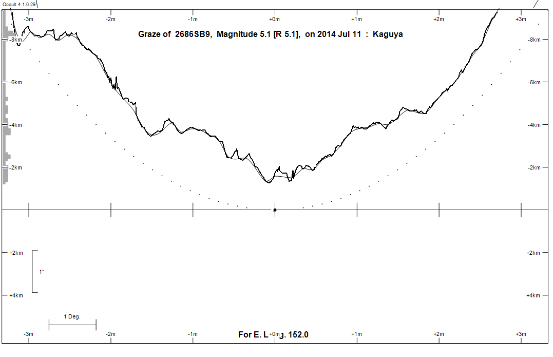
Grazing Occultation of    2686SB9      Magnitude 5.1 [Red = 5.1]
Date: 2014 Jul 11 16h 23m,  to  2014 Jul 11 16h 59m

Nominal site altitude 100m

E. Longit.   Latitude     U.T.    Sun  Moon   TanZ   PA    AA      CA
   o  '  "    o  '  "   h  m  s   Alt Alt Az          o     o      o
 133  0  0  -31 59 30  16 22 42       60 289  0.58 168.6 171.32  31.61S
 133 30  0  -31 49 55  16 23 40       59 288  0.60 168.5 171.23  31.69S
 134  0  0  -31 40 11  16 24 38       59 287  0.61 168.4 171.15  31.77S
 134 30  0  -31 30 20  16 25 35       58 286  0.62 168.3 171.07  31.85S
 135  0  0  -31 20 22  16 26 32       58 285  0.64 168.2 171.00  31.92S
 135 30  0  -31 10 16  16 27 29       57 284  0.65 168.2 170.92  31.99S
 136  0  0  -31  0  2  16 28 26       56 284  0.66 168.1 170.85  32.06S
 136 30  0  -30 49 41  16 29 22       56 283  0.68 168.0 170.78  32.13S
 137  0  0  -30 39 13  16 30 18       55 282  0.69 168.0 170.72  32.19S
 137 30  0  -30 28 38  16 31 14       55 281  0.71 167.9 170.65  32.26S
 138  0  0  -30 17 57  16 32  9       54 280  0.73 167.8 170.59  32.32S
 138 30  0  -30  7  8  16 33  4       53 280  0.74 167.8 170.52  32.38S
 139  0  0  -29 56 14  16 33 59       53 279  0.76 167.7 170.46  32.44S
 139 30  0  -29 45 13  16 34 53       52 278  0.77 167.6 170.41  32.49S
 140  0  0  -29 34  6  16 35 47       52 277  0.79 167.6 170.35  32.55S
 140 30  0  -29 22 53  16 36 41       51 277  0.81 167.5 170.29  32.61S
 141  0  0  -29 11 34  16 37 34       50 276  0.83 167.5 170.24  32.66S
 141 30  0  -29  0 10  16 38 27       50 275  0.84 167.4 170.19  32.71S
 142  0  0  -28 48 40  16 39 19       49 275  0.86 167.4 170.14  32.75S
 142 30  0  -28 37  6  16 40 11       49 274  0.88 167.3 170.10  32.79S
 143  0  0  -28 25 26  16 41  3       48 274  0.90 167.3 170.05  32.84S
 143 30  0  -28 13 41  16 41 54       47 273  0.92 167.3 170.01  32.88S
 144  0  0  -28  1 52  16 42 44       47 272  0.94 167.2 169.97  32.91S
 144 30  0  -27 49 59  16 43 34       46 272  0.96 167.2 169.94  32.95S
 145  0  0  -27 38  1  16 44 24       46 271  0.98 167.1 169.90  32.98S
 145 30  0  -27 25 59  16 45 13       45 271  1.00 167.1 169.87  33.02S
 146  0  0  -27 13 53  16 46  1       44 270  1.03 167.1 169.84  33.05S
 146 30  0  -27  1 44  16 46 49       44 270  1.05 167.0 169.81  33.07S
 147  0  0  -26 49 31  16 47 37       43 269  1.07 167.0 169.78  33.10S
 147 30  0  -26 37 16  16 48 24       42 269  1.09 167.0 169.75  33.12S
 148  0  0  -26 24 57  16 49 10       42 268  1.12 167.0 169.73  33.15S
 148 30  0  -26 12 35  16 49 56       41 268  1.14 166.9 169.71  33.17S
 149  0  0  -26  0 10  16 50 41       41 267  1.17 166.9 169.68  33.19S
 149 30  0  -25 47 44  16 51 26       40 267  1.20 166.9 169.67  33.21S
 150  0  0  -25 35 15  16 52 10       39 266  1.22 166.9 169.65  33.22S
 150 30  0  -25 22 43  16 52 53       39 266  1.25 166.9 169.63  33.24S
 151  0  0  -25 10 10  16 53 36       38 266  1.28 166.9 169.62  33.25S
 151 30  0  -24 57 36  16 54 18       37 265  1.31 166.8 169.61  33.26S
 152  0  0  -24 45  0  16 54 59       37 265  1.34 166.8 169.60  33.27S
 152 30  0  -24 32 22  16 55 40       36 264  1.37 166.8 169.59  33.28S
 153  0  0  -24 19 44  16 56 20       36 264  1.40 166.8 169.58  33.29S
 153 30  0  -24  7  4  16 57  0       35 264  1.43 166.8 169.57  33.29S
 154  0  0  -23 54 24  16 57 39       34 263  1.47 166.8 169.57  33.29S
 154 30  0  -23 41 43  16 58 17       34 263  1.50 166.8 169.57  33.30S
 155  0  0  -23 29  2  16 58 55       33 263  1.54 166.8 169.57  33.30S

Path coordinates are referred to WGS84 (as used by GPS), with the
nominal site altitude being referenced to Mean Sea Level. The path
is adjusted for the effects of refraction at low moon altitudes.

2686 is triple:
  This next pair is not confirmed
  **Aa,Ab 6.0 6.0 0.10"  90.0 (OCc  22) Graze path of ? 0.05 km north, and 0.2 secs later compared to the primary
  AB 5.1 14.1 22.9" 181.9 (SEE 354) Graze path of B 46.06 km north, and 12.3 secs earlier compared to A

                Librations  Long -4.09   Lat -6.58
                            P +170.38     D -6.93
      Illumination of moon  99%+
        Elongation of Moon  167
    Vertical Profile Scale  1.96 km/arcsec at mean distance of moon
   Horizontal Scale Factor  1.63 deg/min


At longitude 144.00:
Limiting Magnitudes for various telescope apertures (in cm)
      CA\Tdia   5    10    15    20    25    30    35
    28.9      4.4   5.8   6.6   7.1   7.4   7.6   7.8
    30.9      4.4   5.8   6.6   7.1   7.4   7.6   7.8
    32.9      4.5   5.9   6.7   7.1   7.5   7.7   7.9
    34.9      4.6   6.0   6.8   7.3   7.6   7.9   8.0
    36.9      4.7   6.2   6.9   7.4   7.8   8.0   8.2

------------------------------------------------------------------------------
Double star catalogue details
WDS entries

  RA  Dec Name          Y1   Y2     N  PA  PA   Sep   Sep  M1    M2
18314-1824OCC  22Aa,Ab 1923 1923    0  -1  -1   0.1   0.1  6.0   6.0  A0Vn      -002-021                        183126.30-182409.5
18314-1824SEE 354AB    1897 2000    6 183 182  25.5  23.2  5.14 14.1  A0Vn      -006-023          -18 4988      183126.30-182409.5

------------------------------------------------------------------------------
Results of Observer Scan                                    UT
Site                              Long.   Lat.   Dist.    h  m  s
Albany                            117.8  -35.0    71km   15 52 48
Bundaberg                         152.3  -24.8    19km   16 55 27
Rockhampton                       150.5  -23.4   203km   16 52 53
Lunar Limb Profile - Bundaberg