Predictions for Grazing Occultation of SAO 159935, 2014 Sep 2, Mayborough, Qld
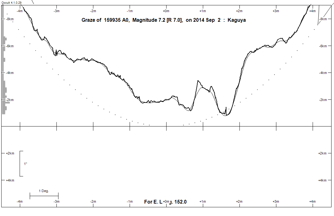
Graze profile Maryborough
Grazing Occultation of  159935 A0      Magnitude 7.2 [Red = 7.0]
Date: 2014 Sep 02  8h 38m,  to  2014 Sep 02  9h 28m

Nominal site altitude 100m

E. Longit.   Latitude     U.T.    Sun  Moon   TanZ   PA    AA      CA
   o  '  "    o  '  "   h  m  s   Alt Alt Az          o     o      o
 133  0  0  -25  0 19   8 37 45    3  82  26  0.13 189.8 179.98  -1.13S
 133 30  0  -25  5 32   8 39  0    3  83  21  0.13 189.7 179.82  -0.97S
 134  0  0  -25 10 33   8 40 15    2  83  15  0.13 189.5 179.64  -0.80S
 134 30  0  -25 15 20   8 41 30    1  83   8  0.13 189.3 179.47  -0.62S
 135  0  0  -25 19 55   8 42 45    0  83   2  0.13 189.2 179.30  -0.45S
 135 30  0  -25 24 17   8 44  0    0  83 356  0.13 189.0 179.12  -0.27S
 136  0  0  -25 28 26   8 45 15   -1  83 350  0.13 188.8 178.95  -0.10S
 136 30  0  -25 32 23   8 46 29   -2  82 344  0.13 188.6 178.77   0.08S
 137  0  0  -25 36  7   8 47 43   -2  82 339  0.14 188.5 178.59   0.25S
 137 30  0  -25 39 38   8 48 57   -3  82 334  0.15 188.3 178.42   0.43S
 138  0  0  -25 42 56   8 50 10   -4  81 330  0.15 188.1 178.24   0.61S
 138 30  0  -25 46  2   8 51 24   -5  81 326  0.16 187.9 178.06   0.78S
 139  0  0  -25 48 55   8 52 37   -5  80 322  0.17 187.7 177.89   0.96S
 139 30  0  -25 51 35   8 53 50   -6  80 319  0.18 187.6 177.71   1.14S
 140  0  0  -25 54  3   8 55  2   -7  79 315  0.19 187.4 177.53   1.32S
 140 30  0  -25 56 18   8 56 14   -8  79 313  0.20 187.2 177.35   1.49S
 141  0  0  -25 58 20   8 57 26   -8  78 310  0.21 187.0 177.18   1.67S
 141 30  0  -26  0 11   8 58 38   -9  78 308  0.22 186.9 177.01   1.84S
 142  0  0  -26  1 48   8 59 49  -10  77 305  0.23 186.7 176.83   2.02S
 142 30  0  -26  3 14   9  1  0  -10  77 303  0.24 186.5 176.65   2.19S
 143  0  0  -26  4 27   9  2 11  -11  76 302  0.25 186.3 176.48   2.37S
 143 30  0  -26  5 27   9  3 21  -12  75 300  0.26 186.2 176.30   2.54S
 144  0  0  -26  6 16   9  4 31       75 298  0.27 186.0 176.13   2.72S
 144 30  0  -26  6 52   9  5 41       74 297  0.29 185.8 175.95   2.89S
 145  0  0  -26  7 17   9  6 50       73 295  0.30 185.6 175.78   3.06S
 145 30  0  -26  7 29   9  7 59       73 294  0.31 185.5 175.61   3.23S
 146  0  0  -26  7 30   9  9  7       72 293  0.32 185.3 175.44   3.40S
 146 30  0  -26  7 18   9 10 15       71 292  0.34 185.1 175.27   3.57S
 147  0  0  -26  6 55   9 11 23       71 291  0.35 185.0 175.11   3.73S
 147 30  0  -26  6 21   9 12 30       70 290  0.36 184.8 174.95   3.90S
 148  0  0  -26  5 34   9 13 37       69 289  0.37 184.6 174.78   4.06S
 148 30  0  -26  4 36   9 14 44       69 288  0.39 184.5 174.62   4.22S
 149  0  0  -26  3 27   9 15 50       68 287  0.40 184.3 174.46   4.38S
 149 30  0  -26  2  7   9 16 56       67 286  0.41 184.2 174.30   4.54S
 150  0  0  -26  0 35   9 18  1       67 285  0.43 184.0 174.14   4.70S
 150 30  0  -25 58 52   9 19  6       66 284  0.44 183.9 173.99   4.86S
 151  0  0  -25 56 58   9 20 10       65 283  0.46 183.7 173.83   5.01S
 151 30  0  -25 54 53   9 21 14       65 283  0.47 183.5 173.68   5.16S
 152  0  0  -25 52 38   9 22 18       64 282  0.48 183.4 173.53   5.32S
 152 30  0  -25 50 11   9 23 21       63 281  0.50 183.2 173.38   5.46S
 153  0  0  -25 47 34   9 24 23       63 281  0.51 183.1 173.23   5.61S
 153 30  0  -25 44 47   9 25 25       62 280  0.53 183.0 173.09   5.76S
 154  0  0  -25 41 49   9 26 27       61 279  0.54 182.8 172.94   5.90S
 154 30  0  -25 38 41   9 27 28       61 279  0.56 182.7 172.80   6.04S
 155  0  0  -25 35 23   9 28 29       60 278  0.57 182.5 172.66   6.18S

Path coordinates are referred to WGS84 (as used by GPS), with the
nominal site altitude being referenced to Mean Sea Level. The path
is adjusted for the effects of refraction at low moon altitudes.


    C A S S I N I   R E G I O N   G R A Z E
                Librations  Long -7.42   Lat -5.14
                            P +176.78     D -5.37
      Illumination of moon  49%+
        Elongation of Moon  89
    Vertical Profile Scale  1.88 km/arcsec at mean distance of moon
   Horizontal Scale Factor  1.23 deg/min


At longitude 144.00:
Limiting Magnitudes for various telescope apertures (in cm)
      CA\Tdia   5    10    15    20    25    30    35
    -1.3      3.2   4.6   5.4   5.9   6.2   6.5   6.7
     0.7      5.1   6.5   7.3   7.9   8.3   8.5   8.7
     2.7      5.1   6.5   7.4   7.9   8.3   8.5   8.8
     4.7      5.9   7.4   8.2   8.8   9.2   9.5   9.7
     6.7      5.9   7.4   8.2   8.8   9.2   9.5   9.7

------------------------------------------------------------------------------
Results of Observer Scan                                    UT
Site                              Long.   Lat.   Dist.    h  m  s
Brisbane                          153.1  -27.5   185km    9 24 30
Bundaberg                         152.3  -24.8   116km    9 23  0
Rockhampton                       150.5  -23.4   289km    9 19  6
Lunar Limb Profile - Maryborough.