Predictions for Grazing Occultation of ZC 600, 2015 Feb 25
Graze profile
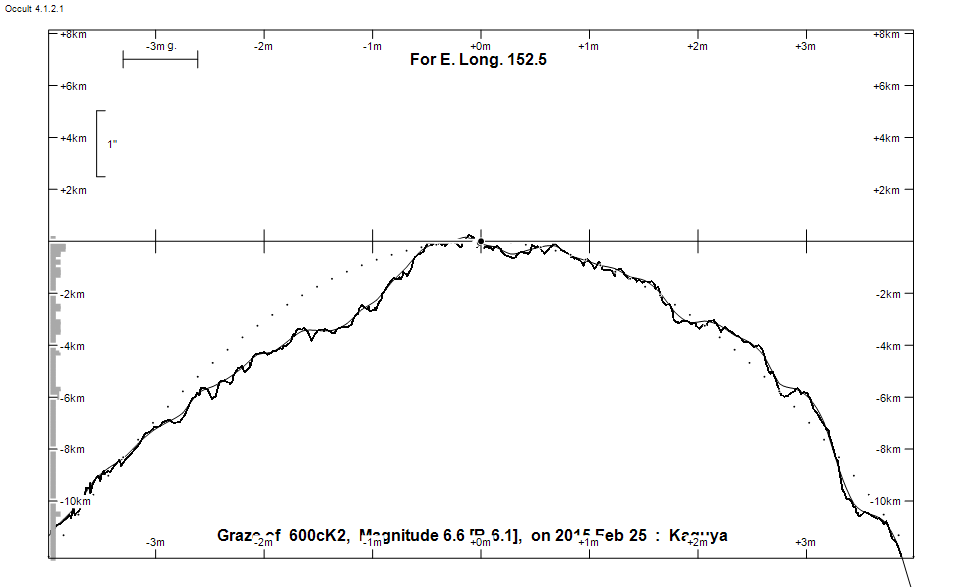
Grazing Occultation of     600cK2      Magnitude 6.6 [Red = 6.1]
Date: 2015 Feb 25 10h 20m,  to  2015 Feb 25 10h 53m

Nominal site altitude 50m

E. Longit.   Latitude     U.T.    Sun  Moon   TanZ   PA    AA      CA
   o  '  "    o  '  "   h  m  s   Alt Alt Az          o     o      o
 135  0  0  -23 52 10  10 19 48  -11  43 329  1.08 352.1   4.05   2.83N
 135 30  0  -23 52  2  10 20 54  -12  42 328  1.10 352.2   4.23   3.01N
 136  0  0  -23 52 10  10 22  0       42 327  1.11 352.4   4.40   3.18N
 136 30  0  -23 52 35  10 23  5       42 326  1.13 352.6   4.57   3.35N
 137  0  0  -23 53 15  10 24  9       41 325  1.14 352.8   4.74   3.52N
 137 30  0  -23 54 11  10 25 13       41 325  1.16 352.9   4.90   3.68N
 138  0  0  -23 55 22  10 26 15       40 324  1.18 353.1   5.06   3.85N
 138 30  0  -23 56 49  10 27 17       40 323  1.19 353.2   5.23   4.01N
 139  0  0  -23 58 30  10 28 18       39 322  1.21 353.4   5.38   4.17N
 139 30  0  -24  0 26  10 29 18       39 322  1.23 353.6   5.54   4.32N
 140  0  0  -24  2 37  10 30 17       39 321  1.25 353.7   5.69   4.48N
 140 30  0  -24  5  2  10 31 16       38 320  1.27 353.9   5.84   4.63N
 141  0  0  -24  7 40  10 32 13       38 319  1.30 354.0   5.99   4.77N
 141 30  0  -24 10 32  10 33 10       37 319  1.32 354.2   6.14   4.92N
 142  0  0  -24 13 37  10 34  6       37 318  1.34 354.3   6.28   5.06N
 142 30  0  -24 16 56  10 35  0       36 318  1.37 354.4   6.42   5.20N
 143  0  0  -24 20 27  10 35 54       36 317  1.39 354.6   6.56   5.34N
 143 30  0  -24 24 10  10 36 47       35 316  1.42 354.7   6.69   5.47N
 144  0  0  -24 28  6  10 37 39       35 316  1.44 354.8   6.82   5.60N
 144 30  0  -24 32 14  10 38 31       34 315  1.47 355.0   6.95   5.73N
 145  0  0  -24 36 33  10 39 21       34 315  1.50 355.1   7.08   5.86N
 145 30  0  -24 41  4  10 40 10       33 314  1.53 355.2   7.20   5.98N
 146  0  0  -24 45 46  10 40 58       33 313  1.56 355.3   7.32   6.10N
 146 30  0  -24 50 39  10 41 46       32 313  1.59 355.5   7.44   6.22N
 147  0  0  -24 55 42  10 42 32       32 312  1.62 355.6   7.55   6.33N
 147 30  0  -25  0 56  10 43 18       31 312  1.66 355.7   7.66   6.44N
 148  0  0  -25  6 19  10 44  3       31 311  1.69 355.8   7.77   6.55N
 148 30  0  -25 11 53  10 44 46       30 311  1.73 355.9   7.88   6.66N
 149  0  0  -25 17 36  10 45 29       30 310  1.77 356.0   7.98   6.76N
 149 30  0  -25 23 28  10 46 11       29 310  1.80 356.1   8.08   6.86N
 150  0  0  -25 29 29  10 46 52       28 310  1.84 356.2   8.18   6.96N
 150 30  0  -25 35 39  10 47 32       28 309  1.89 356.3   8.28   7.06N
 151  0  0  -25 41 58  10 48 11       27 309  1.93 356.4   8.37   7.15N
 151 30  0  -25 48 25  10 48 50       27 308  1.97 356.5   8.46   7.24N
 152  0  0  -25 55  0  10 49 27       26 308  2.02 356.6   8.55   7.33N
 152 30  0  -26  1 43  10 50  3       26 307  2.07 356.6   8.63   7.41N
 153  0  0  -26  8 34  10 50 39       25 307  2.12 356.7   8.71   7.50N
 153 30  0  -26 15 32  10 51 13       25 307  2.17 356.8   8.80   7.58N
 154  0  0  -26 22 37  10 51 47       24 306  2.22 356.9   8.87   7.65N
 154 30  0  -26 29 49  10 52 20       24 306  2.28 357.0   8.95   7.73N
 155  0  0  -26 37  8  10 52 52       23 305  2.34 357.0   9.02   7.80N

Path coordinates are referred to WGS84 (as used by GPS), with the
nominal site altitude being referenced to Mean Sea Level. The path
is adjusted for the effects of refraction at low moon altitudes.

Projected diameter of star  2 meters  [Estimated]

600 is double:
  AB 6.7 9.6 0.30"  91.0 (YSC  22) Graze path of B 0.08 km north, and 0.8 secs later compared to A

                Librations  Long +6.93   Lat +4.66
                            P +7.57     D -3.52
      Illumination of moon  47%+
        Elongation of Moon  86
    Vertical Profile Scale  2.54 km/arcsec at mean distance of moon
   Horizontal Scale Factor  1.35 deg/min


At longitude 145.00:
Limiting Magnitudes for various telescope apertures (in cm)
      CA\Tdia   5    10    15    20    25    30    35
     1.9      4.9   6.3   7.1   7.6   7.9   8.1   8.3
     3.9      5.7   7.1   7.9   8.4   8.8   9.0   9.2
     5.9      5.7   7.1   7.9   8.4   8.8   9.0   9.2
     7.9      5.7   7.2   7.9   8.5   8.8   9.1   9.2
     9.9      5.7   7.2   8.0   8.5   8.8   9.1   9.3
------------------------------------------------------------------------------
Results of Observer Scan                                    UT
Site                              Long.   Lat.   Dist.    h  m  s
Brisbane                          153.1  -27.5   141km   10 50 42
Bundaberg                         152.3  -24.8   128km   10 49 51
Rockhampton                       150.5  -23.4   241km   10 47 32
Lunar Limb Profile