Predictions for Grazing Occultation of ZC2110, 2015 Mar 10
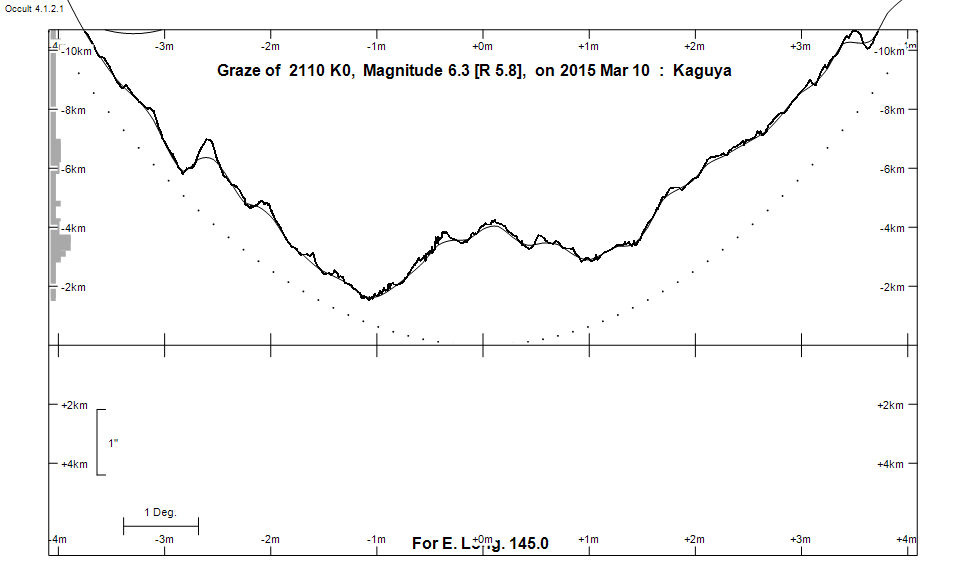
Graze profile
Grazing Occultation of    2110 K0      Magnitude 6.3 [Red = 5.8]
Date: 2015 Mar 10 15h 13m,  to  2015 Mar 10 15h 56m

Nominal site altitude 50m

E. Longit.   Latitude     U.T.    Sun  Moon   TanZ   PA    AA      CA
   o  '  "    o  '  "   h  m  s   Alt Alt Az          o     o      o
 135  0  0  -33  0  9  15 12 47       39  79  1.21 201.7 183.26   7.07S
 135 30  0  -33 14 58  15 13 46       40  78  1.19 201.7 183.29   7.10S
 136  0  0  -33 29 49  15 14 45       41  78  1.17 201.8 183.31   7.12S
 136 30  0  -33 44 43  15 15 45       41  77  1.14 201.8 183.33   7.14S
 137  0  0  -33 59 38  15 16 45       42  76  1.12 201.8 183.35   7.16S
 137 30  0  -34 14 36  15 17 47       42  75  1.10 201.8 183.37   7.18S
 138  0  0  -34 29 34  15 18 48       43  75  1.08 201.8 183.38   7.19S
 138 30  0  -34 44 34  15 19 51       43  74  1.06 201.9 183.40   7.21S
 139  0  0  -34 59 35  15 20 53       44  73  1.04 201.9 183.41   7.22S
 139 30  0  -35 14 36  15 21 57       44  72  1.02 201.9 183.42   7.23S
 140  0  0  -35 29 37  15 23  1       45  71  1.00 201.9 183.42   7.23S
 140 30  0  -35 44 38  15 24  5       45  70  0.99 201.9 183.42   7.23S
 141  0  0  -35 59 38  15 25 10       46  70  0.97 201.9 183.42   7.23S
 141 30  0  -36 14 37  15 26 15       46  69  0.95 201.9 183.42   7.23S
 142  0  0  -36 29 35  15 27 20       47  68  0.94 201.9 183.42   7.23S
 142 30  0  -36 44 31  15 28 26       47  67  0.92 201.9 183.41   7.22S
 143  0  0  -36 59 25  15 29 33       48  66  0.90 201.9 183.40   7.21S
 143 30  0  -37 14 17  15 30 39       48  65  0.89 201.8 183.39   7.20S
 144  0  0  -37 29  5  15 31 46       49  64  0.88 201.8 183.37   7.18S
 144 30  0  -37 43 51  15 32 53       49  63  0.86 201.8 183.35   7.16S
 145  0  0  -37 58 33  15 34  0       50  62  0.85 201.8 183.33   7.14S
 145 30  0  -38 13 12  15 35  8       50  60  0.84 201.8 183.31   7.12S
 146  0  0  -38 27 46  15 36 15       50  59  0.82 201.7 183.28   7.10S
 146 30  0  -38 42 17  15 37 23       51  58  0.81 201.7 183.26   7.07S
 147  0  0  -38 56 42  15 38 30       51  57  0.80 201.7 183.23   7.04S
 147 30  0  -39 11  2  15 39 38       52  56  0.79 201.7 183.19   7.00S
 148  0  0  -39 25 17  15 40 46       52  55  0.78 201.6 183.16   6.97S
 148 30  0  -39 39 26  15 41 54       52  54  0.77 201.6 183.12   6.93S
 149  0  0  -39 53 30  15 43  2       53  52  0.76 201.5 183.08   6.89S
 149 30  0  -40  7 27  15 44  9       53  51  0.75 201.5 183.03   6.85S
 150  0  0  -40 21 18  15 45 17       53  50  0.74 201.4 182.99   6.80S
 150 30  0  -40 35  2  15 46 25       54  49  0.74 201.4 182.94   6.75S
 151  0  0  -40 48 40  15 47 32       54  47  0.73 201.4 182.89   6.70S
 151 30  0  -41  2 10  15 48 39       54  46  0.72 201.3 182.84   6.65S
 152  0  0  -41 15 32  15 49 47       54  45  0.71 201.2 182.78   6.60S
 152 30  0  -41 28 48  15 50 54       55  43  0.71 201.2 182.73   6.54S
 153  0  0  -41 41 55  15 52  0       55  42  0.70 201.1 182.67   6.48S
 153 30  0  -41 54 54  15 53  7       55  41  0.70 201.1 182.61   6.42S
 154  0  0  -42  7 46  15 54 13       55  39  0.69 201.0 182.55   6.36S
 154 30  0  -42 20 29  15 55 19       56  38  0.68 200.9 182.48   6.29S
 155  0  0  -42 33  3  15 56 25       56  37  0.68 200.9 182.41   6.23S

Path coordinates are referred to WGS84 (as used by GPS), with the
nominal site altitude being referenced to Mean Sea Level. The path
is adjusted for the effects of refraction at low moon altitudes.

Projected diameter of star  2 meters  [Estimated]


    C A S S I N I   R E G I O N   G R A Z E
                Librations  Long -6.14   Lat -4.25
                            P +183.75     D -3.63
      Illumination of moon  79%-
        Elongation of Moon  126
    Vertical Profile Scale  2.23 km/arcsec at mean distance of moon
   Horizontal Scale Factor  1.42 deg/min


At longitude 145.00:
Limiting Magnitudes for various telescope apertures (in cm)
      CA\Tdia   5    10    15    20    25    30    35
     3.1      4.3   5.8   6.5   7.0   7.4   7.6   7.8
     5.1      4.7   6.1   6.9   7.4   7.8   8.0   8.2
     7.1      4.9   6.4   7.1   7.7   8.0   8.2   8.4
     9.1      5.6   7.0   7.8   8.3   8.7   8.9   9.1
    11.1      5.6   7.0   7.8   8.3   8.7   9.0   9.1

------------------------------------------------------------------------------
Results of Observer Scan                                    UT
Site                              Long.   Lat.   Dist.    h  m  s
AU Mid                            143.0  -30.6   615km   15 29 33
Bendigo                           144.3  -36.8    80km   15 32 31
Melbourne                         145.0  -37.8    14km   15 33 56
Lunar Limb Profile