Predictions for Grazing Occultation of ZC3045, 2015 May 10
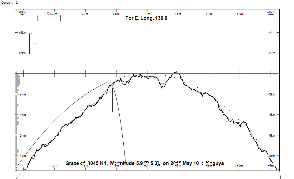
Graze profile
Grazing Occultation of    3045 K1      Magnitude 5.9 [Red = 5.3]
Date: 2015 May 10 19h 11m,  to  2015 May 10 20h  3m

Nominal site altitude 50m

E. Longit.   Latitude     U.T.    Sun  Moon   TanZ   PA    AA      CA
   o  '  "    o  '  "   h  m  s   Alt Alt Az          o     o      o
 135  0  0  -34 58 19  19 11 12       60  47  0.57 342.9 359.55   0.63N
 135 30  0  -34 53  5  19 12 19       61  46  0.56 342.8 359.42   0.77N
 136  0  0  -34 47 39  19 13 26       61  45  0.55 342.7 359.28   0.90N
 136 30  0  -34 42  3  19 14 34       62  43  0.54 342.5 359.15   1.04N
 137  0  0  -34 36 17  19 15 43       62  42  0.53 342.4 359.01   1.17N
 137 30  0  -34 30 19  19 16 52       63  41  0.51 342.3 358.88   1.31N
 138  0  0  -34 24 10  19 18  2       63  40  0.50 342.1 358.74   1.44N
 138 30  0  -34 17 51  19 19 12       64  38  0.49 342.0 358.61   1.58N
 139  0  0  -34 11 20  19 20 23       64  37  0.48 341.8 358.47   1.72N
 139 30  0  -34  4 38  19 21 35       65  36  0.47 341.7 358.33   1.85N
 140  0  0  -33 57 44  19 22 48       65  34  0.46 341.6 358.20   1.99N
 140 30  0  -33 50 40  19 24  1       66  33  0.45 341.4 358.06   2.13N
 141  0  0  -33 43 24  19 25 14       66  31  0.44 341.3 357.92   2.26N
 141 30  0  -33 35 56  19 26 28       67  29  0.43 341.2 357.79   2.40N
 142  0  0  -33 28 17  19 27 43       67  28  0.42 341.0 357.65   2.54N
 142 30  0  -33 20 27  19 28 59       67  26  0.42 340.9 357.52   2.67N
 143  0  0  -33 12 25  19 30 14       68  24  0.41 340.8 357.38   2.81N
 143 30  0  -33  4 11  19 31 31       68  22  0.40 340.6 357.25   2.94N
 144  0  0  -32 55 46  19 32 48       69  20  0.39 340.5 357.11   3.07N
 144 30  0  -32 47  9  19 34  6       69  18  0.38 340.4 356.98   3.21N
 145  0  0  -32 38 20  19 35 24       69  16  0.38 340.2 356.85   3.34N
 145 30  0  -32 29 20  19 36 42       70  14  0.37 340.1 356.72   3.47N
 146  0  0  -32 20  8  19 38  2       70  12  0.36 340.0 356.59   3.60N
 146 30  0  -32 10 44  19 39 21       70   9  0.36 339.8 356.46   3.73N
 147  0  0  -32  1  8  19 40 41       71   7  0.35 339.7 356.33   3.86N
 147 30  0  -31 51 21  19 42  2       71   5  0.35 339.6 356.20   3.98N
 148  0  0  -31 41 23  19 43 23       71   2  0.35 339.5 356.08   4.11N
 148 30  0  -31 31 12  19 44 44       71 360  0.34 339.3 355.96   4.23N
 149  0  0  -31 20 50  19 46  6       71 357  0.34 339.2 355.83   4.35N
 149 30  0  -31 10 17  19 47 28  -11  71 355  0.34 339.1 355.71   4.47N
 150  0  0  -30 59 32  19 48 50  -11  72 352  0.33 339.0 355.60   4.59N
 150 30  0  -30 48 36  19 50 13  -10  72 349  0.33 338.9 355.48   4.71N
 151  0  0  -30 37 28  19 51 36   -9  72 347  0.33 338.7 355.37   4.82N
 151 30  0  -30 26 10  19 52 59   -8  72 344  0.33 338.6 355.25   4.93N
 152  0  0  -30 14 40  19 54 23   -8  72 341  0.33 338.5 355.14   5.04N
 152 30  0  -30  3  0  19 55 47   -7  71 338  0.34 338.4 355.04   5.15N
 153  0  0  -29 51  8  19 57 11   -6  71 336  0.34 338.3 354.93   5.26N
 153 30  0  -29 39  6  19 58 35   -5  71 333  0.34 338.2 354.83   5.36N
 154  0  0  -29 26 54  19 59 59   -4  71 331  0.34 338.1 354.73   5.46N
 154 30  0  -29 14 31  20  1 23   -4  71 328  0.35 338.0 354.63   5.55N
 155  0  0  -29  1 59  20  2 48   -3  71 325  0.35 337.9 354.54   5.65N

Path coordinates are referred to WGS84 (as used by GPS), with the
nominal site altitude being referenced to Mean Sea Level. The path
is adjusted for the effects of refraction at low moon altitudes.

Projected diameter of star  3 meters  [Estimated]


                Librations  Long -3.79   Lat -5.95
                            P +357.25     D +6.41
      Illumination of moon  57%-
        Elongation of Moon  98
    Vertical Profile Scale  1.96 km/arcsec at mean distance of moon
   Horizontal Scale Factor  1.33 deg/min


At longitude 145.00:
Limiting Magnitudes for various telescope apertures (in cm)
      CA\Tdia   5    10    15    20    25    30    35
    -0.7      3.1   4.5   5.3   5.8   6.1   6.4   6.5
     1.3      5.0   6.4   7.3   7.8   8.1   8.4   8.6
     3.3      5.0   6.5   7.3   7.8   8.2   8.4   8.6
     5.3      5.8   7.3   8.1   8.7   9.1   9.3   9.6
     7.3      5.9   7.3   8.1   8.7   9.1   9.4   9.6

------------------------------------------------------------------------------
Results of Observer Scan                                    UT
Site                              Long.   Lat.   Dist.    h  m  s
AU Mid                            143.0  -30.6   275km   19 30 14
Brisbane                          153.1  -27.5   239km   19 57 19
Newcastle                         151.7  -33.0   262km   19 53 36
Pt Macquarie                      152.8  -31.4   149km   19 56 43
Lunar Limb Profile