Predictions for Grazing Occultation of ZC2764, 2015 Mar 14
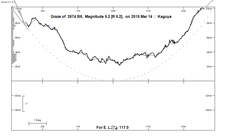
Graze profile
Grazing Occultation of    2674 B8      Magnitude 6.2 [Red = 6.2]  s
Date: 2015 Mar 14 17h 23m,  to  2015 Mar 14 17h 30m

Nominal site altitude 50m

E. Longit.   Latitude     U.T.    Sun  Moon   TanZ   PA    AA      CA
   o  '  "    o  '  "   h  m  s   Alt Alt Az          o     o      o
 110  0  0  -32 31 18  17 23 16        6 107  9.76 183.3 186.09   4.86S
 110 30  0  -32 41 21  17 23 22        6 107  9.02 183.3 186.09   4.87S
 111  0  0  -32 51 25  17 23 29        7 107  8.39 183.3 186.09   4.87S
 111 30  0  -33  1 30  17 23 36        7 106  7.84 183.3 186.10   4.87S
 112  0  0  -33 11 34  17 23 44        8 106  7.35 183.3 186.10   4.87S
 112 30  0  -33 21 39  17 23 52        8 106  6.92 183.3 186.10   4.87S
 113  0  0  -33 31 45  17 24  1        9 106  6.53 183.3 186.11   4.88S
 113 30  0  -33 41 50  17 24 10        9 105  6.19 183.3 186.11   4.88S
 114  0  0  -33 51 55  17 24 20       10 105  5.88 183.3 186.11   4.88S
 114 30  0  -34  2  0  17 24 30       10 105  5.59 183.3 186.11   4.88S
 115  0  0  -34 12  5  17 24 41       11 104  5.34 183.3 186.11   4.88S
 115 30  0  -34 22 10  17 24 52       11 104  5.10 183.3 186.10   4.88S
 116  0  0  -34 32 15  17 25  3       12 104  4.88 183.3 186.10   4.87S
 116 30  0  -34 42 19  17 25 15       12 103  4.68 183.3 186.10   4.87S
 117  0  0  -34 52 23  17 25 28       13 103  4.50 183.3 186.09   4.87S
 117 30  0  -35  2 26  17 25 41       13 103  4.33 183.3 186.09   4.86S
 118  0  0  -35 12 29  17 25 54       13 102  4.17 183.3 186.08   4.85S
 118 30  0  -35 22 31  17 26  8       14 102  4.02 183.3 186.07   4.85S
 119  0  0  -35 32 32  17 26 23       14 102  3.88 183.3 186.07   4.84S
 119 30  0  -35 42 32  17 26 38       15 101  3.75 183.3 186.06   4.83S
 120  0  0  -35 52 33  17 26 53       15 101  3.63 183.3 186.05   4.82S
 120 30  0  -36  2 31  17 27  9       16 101  3.51 183.3 186.04   4.81S
 121  0  0  -36 12 28  17 27 26       16 100  3.40 183.3 186.03   4.80S
 121 30  0  -36 22 24  17 27 43       17 100  3.30 183.2 186.02   4.79S
 122  0  0  -36 32 18  17 28  0       17 100  3.20 183.2 186.01   4.78S
 122 30  0  -36 42 11  17 28 18       18  99  3.11 183.2 185.99   4.77S
 123  0  0  -36 52  2  17 28 36       18  99  3.02 183.2 185.98   4.75S
 123 30  0  -37  1 52  17 28 55       19  98  2.94 183.2 185.96   4.74S
 124  0  0  -37 11 40  17 29 14       19  98  2.86 183.2 185.95   4.72S
 124 30  0  -37 21 27  17 29 34       20  98  2.78 183.2 185.93   4.71S
 125  0  0  -37 31 11  17 29 54       20  97  2.71 183.1 185.92   4.69S

Path coordinates are referred to WGS84 (as used by GPS), with the
nominal site altitude being referenced to Mean Sea Level. The path
is adjusted for the effects of refraction at low moon altitudes.

2674 is variable:
      2674 = NSV 10835, 6.17 to 6.20, V


    C A S S I N I   R E G I O N   G R A Z E
                Librations  Long -6.57   Lat -7.27
                            P +186.89     D -6.27
      Illumination of moon  39%-
        Elongation of Moon  77
    Vertical Profile Scale  2.13 km/arcsec at mean distance of moon
   Horizontal Scale Factor  2.01 deg/min


At longitude 117.50:
Limiting Magnitudes for various telescope apertures (in cm)
      CA\Tdia   5    10    15    20    25    30    35
     0.9      4.3   5.6   6.3   6.7   6.9   7.1   7.2
     2.9      4.3   5.7   6.3   6.7   7.0   7.1   7.2
     4.9      5.0   6.4   7.1   7.5   7.8   8.0   8.1
     6.9      5.0   6.4   7.1   7.6   7.8   8.0   8.1
     8.9      5.0   6.4   7.2   7.6   7.9   8.0   8.2

------------------------------------------------------------------------------
Results of Observer Scan                                    UT
Site                              Long.   Lat.   Dist.    h  m  s
Ash Pennell, Dunedin              170.5  -45.9   130km   18 24 42
Bob Evans, Invercargill           168.3  -46.4    53km   18 21 23
Chris Chad, Hobart                147.5  -42.9   105km   17 52 10
Lunar Limb Profile