Predictions for Grazing Occultation of ZC2969, 2015 Jun 6
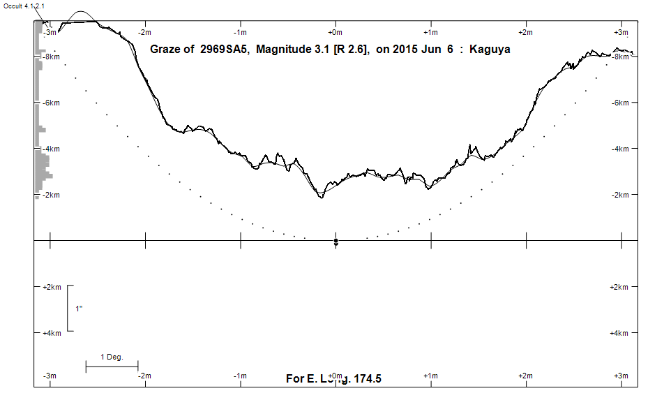
Graze profile
Grazing Occultation of    2969SA5      Magnitude 3.1 [Red = 2.6]  s
   R2969 = Dabih Major = beta Capricorni
Date: 2015 Jun 06 10h 53m,  to  2015 Jun 06 11h  0m

Nominal site altitude 50m

E. Longit.   Latitude     U.T.    Sun  Moon   TanZ   PA    AA      CA
   o  '  "    o  '  "   h  m  s   Alt Alt Az          o     o      o
 167  0  0  -34 38  1  10 52 54       16  97  3.53 173.7 187.85  11.35S
 167 30  0  -34 44 34  10 53  7       16  97  3.43 173.7 187.81  11.31S
 168  0  0  -34 51  2  10 53 21       17  97  3.33 173.7 187.77  11.26S
 168 30  0  -34 57 27  10 53 36       17  96  3.23 173.6 187.73  11.22S
 169  0  0  -35  3 48  10 53 50       18  96  3.14 173.6 187.69  11.18S
 169 30  0  -35 10  5  10 54  6       18  96  3.05 173.5 187.65  11.14S
 170  0  0  -35 16 19  10 54 21       19  95  2.97 173.5 187.60  11.10S
 170 30  0  -35 22 29  10 54 38       19  95  2.89 173.4 187.56  11.05S
 171  0  0  -35 28 34  10 54 54       20  95  2.81 173.4 187.51  11.01S
 171 30  0  -35 34 36  10 55 11       20  94  2.74 173.4 187.47  10.96S
 172  0  0  -35 40 33  10 55 28       21  94  2.67 173.3 187.42  10.91S
 172 30  0  -35 46 27  10 55 46       21  93  2.61 173.3 187.37  10.87S
 173  0  0  -35 52 16  10 56  4       21  93  2.55 173.2 187.33  10.82S
 173 30  0  -35 58  1  10 56 23       22  93  2.49 173.2 187.28  10.77S
 174  0  0  -36  3 41  10 56 42       22  92  2.43 173.1 187.23  10.72S
 174 30  0  -36  9 18  10 57  1       23  92  2.37 173.1 187.18  10.67S
 175  0  0  -36 14 49  10 57 21       23  92  2.32 173.0 187.12  10.62S
 175 30  0  -36 20 16  10 57 41       24  91  2.27 173.0 187.07  10.57S
 176  0  0  -36 25 39  10 58  2       24  91  2.22 172.9 187.02  10.51S
 176 30  0  -36 30 57  10 58 23       25  90  2.17 172.8 186.96  10.46S
 177  0  0  -36 36 10  10 58 45       25  90  2.12 172.8 186.91  10.40S
 177 30  0  -36 41 19  10 59  6       26  90  2.08 172.7 186.85  10.35S
 178  0  0  -36 46 23  10 59 29       26  89  2.03 172.7 186.80  10.29S
 178 30  0  -36 51 22  10 59 51       27  89  1.99 172.6 186.74  10.23S
 179  0  0  -36 56 16  11  0 15       27  88  1.95 172.6 186.68  10.18S

Path coordinates are referred to WGS84 (as used by GPS), with the
nominal site altitude being referenced to Mean Sea Level. The path
is adjusted for the effects of refraction at low moon altitudes.

Projected diameter of star  7 meters  [CHARM/CADARS, 12 measures]

2969 is variable:
      2969 = NSV 25105, 3.05, range 0.00, 3V, Type VAR, Period 1.40657 days

2969 is multiple:
  Aa,Ab 3.1 4.9 0.09" 211.0 (BLA   7) Graze path of Ab 0.14 km north, and 0.1 secs earlier compared to Aa
  AD 3.2 13.7 116" 291.7 (HJ 2948) Graze path of D 113.85 km south, and 198.1 secs earlier compared to A
  AB 3.2 6.1 205" 267.0 (STFA 52) Graze path of B 27.68 km south, and 396.5 secs earlier compared to A
  AC 3.2 8.8 226" 133.0 (STFA 52) Graze path of C 353.35 km north, and 282.5 secs later compared to A

    C A S S I N I   R E G I O N   G R A Z E
                Librations  Long -2.36   Lat -6.21
                            P +187.60     D -5.60
      Illumination of moon  83%-
        Elongation of Moon  131
    Vertical Profile Scale  1.99 km/arcsec at mean distance of moon
   Horizontal Scale Factor  1.85 deg/min


At longitude 173.00:
Limiting Magnitudes for various telescope apertures (in cm)
      CA\Tdia   5    10    15    20    25    30    35
     6.8      4.3   5.7   6.4   6.8   7.0   7.2   7.3
     8.8      4.8   6.2   6.9   7.3   7.6   7.7   7.9
    10.8      5.1   6.5   7.2   7.6   7.9   8.1   8.2
    12.8      5.1   6.5   7.2   7.6   7.9   8.1   8.2
    14.8      5.1   6.5   7.2   7.7   7.9   8.1   8.2

------------------------------------------------------------------------------
Double star catalogue details
WDS entries

  RA  Dec Name          Y1   Y2     N  PA  PA   Sep   Sep  M1    M2
20210-1447BLA   7Aa,Ab 1976 1992    7  49  48   0.0   0.0  3.1   4.9  F8V  A0   +042+002          -15 5629 NO   202100.67-144653.0
20210-1447STFA 52AB    1800 2012   41 268 267 205.5 205.4  3.15  6.08 F8V  A0   +045+007 +043+000          N D  202100.67-144653.0
20210-1447STFA 52AC    1905 2012   11 134 133 227.4 226.1  3.15  8.83 F8V  A0   +045+007 +039+006 -15 5631 N    202100.67-144653.0
20210-1447HJ 2948AD    1891 2000    3 294 292 111.7 115.9  3.15 12.96 A0III     +045+007 +015-034          N    202100.67-144653.0
20210-1447BAR  12Ba,Bb 1884 2008   19 106  64   0.9   0.5  6.16  9.14 A0III     +042+002          -15 5626 NO   202046.55-144705.5
20210-1447STFA 52BC    1895 2000   13 112 111 397.4 396.7  6.08  8.83 A0III     +043+000 +039+006 -15 5626 N    202046.55-144705.5
20210-1447HJ 2948DE    1823 2000    8 300 321   8.0   3.9 13.7  14.4            +015-034 -058+060          N    202053.25-144608.7


------------------------------------------------------------------------------
Results of Observer Scan                                    UT
Site                              Long.   Lat.   Dist.    h  m  s
Auckland                          174.8  -36.9    75km   10 57 13
MidNZ                             173.0  -41.0   552km   10 56  4
Lunar Limb Profile