Predictions for Grazing Occultation of ZC3520, 2015 Jul 7
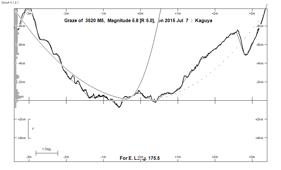
Graze profile
Grazing Occultation of    3520 M5      Magnitude 5.8 [Red = 5.0]  v
Date: 2015 Jul 07 13h 36m,  to  2015 Jul 07 13h 44m

Nominal site altitude 50m

E. Longit.   Latitude     U.T.    Sun  Moon   TanZ   PA    AA      CA
   o  '  "    o  '  "   h  m  s   Alt Alt Az          o     o      o
 167  0  0  -41 41 39  13 35 53       20  71  2.76 158.4 183.34   2.07S
 167 30  0  -41 37 22  13 36  8       20  71  2.70 158.3 183.27   2.00S
 168  0  0  -41 32 59  13 36 23       21  70  2.64 158.2 183.19   1.92S
 168 30  0  -41 28 30  13 36 39       21  70  2.58 158.2 183.12   1.85S
 169  0  0  -41 23 54  13 36 55       22  69  2.52 158.1 183.04   1.77S
 169 30  0  -41 19 13  13 37 11       22  69  2.47 158.0 182.97   1.70S
 170  0  0  -41 14 25  13 37 28       22  69  2.42 157.9 182.89   1.62S
 170 30  0  -41  9 32  13 37 45       23  68  2.37 157.9 182.81   1.54S
 171  0  0  -41  4 32  13 38  3       23  68  2.32 157.8 182.73   1.46S
 171 30  0  -40 59 25  13 38 21       24  67  2.27 157.7 182.65   1.39S
 172  0  0  -40 54 12  13 38 40       24  67  2.23 157.6 182.58   1.31S
 172 30  0  -40 48 53  13 38 59       25  67  2.18 157.5 182.50   1.23S
 173  0  0  -40 43 27  13 39 18       25  66  2.14 157.5 182.42   1.15S
 173 30  0  -40 37 54  13 39 38       26  66  2.09 157.4 182.33   1.06S
 174  0  0  -40 32 15  13 39 58       26  65  2.05 157.3 182.25   0.98S
 174 30  0  -40 26 29  13 40 19       26  65  2.01 157.2 182.17   0.90S
 175  0  0  -40 20 37  13 40 41       27  64  1.97 157.1 182.09   0.82S
 175 30  0  -40 14 37  13 41  2       27  64  1.94 157.0 182.00   0.73S
 176  0  0  -40  8 30  13 41 25       28  64  1.90 157.0 181.92   0.65S
 176 30  0  -40  2 17  13 41 48       28  63  1.86 156.9 181.84   0.57S
 177  0  0  -39 55 56  13 42 11       29  63  1.83 156.8 181.75   0.48S
 177 30  0  -39 49 28  13 42 35       29  62  1.79 156.7 181.66   0.39S
 178  0  0  -39 42 53  13 42 59       30  62  1.76 156.6 181.59   0.32S
 178 30  0  -39 36 11  13 43 24       30  61  1.73 156.5 181.50   0.23S
 179  0  0  -39 29 21  13 43 49       31  61  1.70 156.5 181.41   0.14S

Path coordinates are referred to WGS84 (as used by GPS), with the
nominal site altitude being referenced to Mean Sea Level. The path
is adjusted for the effects of refraction at low moon altitudes.

Projected diameter of star  14 meters  [CHARM/CADARS, 2 measures]

3520 is variable:
      3520 = XZ Psc, 5.61 to 5.97, V, Type SR


                Librations  Long +2.41   Lat -1.05
                            P +182.38     D -0.89
      Illumination of moon  64%-
        Elongation of Moon  106
    Vertical Profile Scale  2.05 km/arcsec at mean distance of moon
   Horizontal Scale Factor  1.74 deg/min


At longitude 173.00:
Limiting Magnitudes for various telescope apertures (in cm)
      CA\Tdia   5    10    15    20    25    30    35
    -2.9      2.8   4.2   4.8   5.2   5.5   5.7   5.8
    -0.9      2.8   4.2   4.8   5.2   5.5   5.7   5.8
     1.1      3.8   5.2   5.9   6.3   6.6   6.8   6.9
     3.1      4.6   6.0   6.7   7.1   7.4   7.6   7.7
     5.1      5.3   6.7   7.4   7.9   8.2   8.4   8.5

------------------------------------------------------------------------------
Results of Observer Scan                                    UT
Site                              Long.   Lat.   Dist.    h  m  s
Lunar Limb Profile