Predictions for Grazing Occultation of ZC1941, 2016 Jan 30
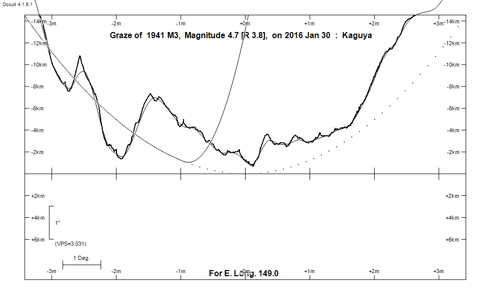
Graze profile
Grazing Occultation of    1941 M3      Magnitude 4.7 [Red = 3.8]  s
   R1941 = 74 Virginis
Date: 2016 Jan 30 14h  9m,  to  2016 Jan 30 14h 27m

Nominal site altitude 100m

E. Longit.   Latitude       U.T.    Sun  Moon   TanZ   PA    AA      CA
   o  '  "    o  '   "    h  m  s   Alt Alt Az          o     o      o
 135  0  0  -31 37 43.6  14  8 45        6  94  9.43 199.9 177.12  -0.55S
 135 30  0  -31 42 53.0  14  8 56        7  93  8.75 200.0 177.19  -0.48S
 136  0  0  -31 48 11.5  14  9  8        7  93  8.15 200.1 177.27  -0.40S
 136 30  0  -31 53 38.5  14  9 20        7  93  7.63 200.2 177.34  -0.33S
 137  0  0  -31 59 14.2  14  9 34        8  93  7.17 200.2 177.41  -0.26S
 137 30  0  -32  4 58.7  14  9 48        8  92  6.75 200.3 177.49  -0.18S
 138  0  0  -32 10 52.0  14 10  3        9  92  6.38 200.4 177.56  -0.11S
 138 30  0  -32 16 54.2  14 10 18        9  92  6.05 200.5 177.64  -0.03S
 139  0  0  -32 23  5.9  14 10 35       10  91  5.75 200.5 177.72   0.05S
 139 30  0  -32 29 26.5  14 10 52       10  91  5.47 200.6 177.79   0.12S
 140  0  0  -32 35 56.5  14 11 10       11  91  5.22 200.7 177.87   0.20S
 140 30  0  -32 42 35.9  14 11 29       11  90  4.99 200.8 177.94   0.28S
 141  0  0  -32 49 24.9  14 11 48       12  90  4.78 200.8 178.02   0.35S
 141 30  0  -32 56 23.5  14 12  9       12  90  4.58 200.9 178.10   0.43S
 142  0  0  -33  3 31.9  14 12 30       13  89  4.40 201.0 178.18   0.51S
 142 30  0  -33 10 50.2  14 12 52       13  89  4.23 201.1 178.26   0.59S
 143  0  0  -33 18 18.4  14 13 15       14  89  4.07 201.1 178.33   0.67S
 143 30  0  -33 25 56.6  14 13 39       14  88  3.93 201.2 178.41   0.74S
 144  0  0  -33 33 45.0  14 14  4       15  88  3.79 201.3 178.49   0.82S
 144 30  0  -33 41 45.0  14 14 29       15  87  3.66 201.4 178.57   0.91S
 145  0  0  -33 49 53.9  14 14 56       16  87  3.54 201.5 178.65   0.98S
 145 30  0  -33 58 13.3  14 15 23       16  87  3.42 201.5 178.73   1.06S
 146  0  0  -34  6 43.2  14 15 52       17  86  3.31 201.6 178.81   1.14S
 146 30  0  -34 15 23.3  14 16 21       17  86  3.21 201.7 178.89   1.22S
 147  0  0  -34 24 14.6  14 16 51       18  86  3.11 201.8 178.97   1.30S
 147 30  0  -34 33 16.7  14 17 22       18  85  3.02 201.9 179.05   1.38S
 148  0  0  -34 42 29.7  14 17 54       19  85  2.93 201.9 179.13   1.46S
 148 30  0  -34 51 53.7  14 18 27       19  84  2.85 202.0 179.21   1.54S
 149  0  0  -35  1 28.8  14 19  1       20  84  2.77 202.1 179.29   1.62S
 149 30  0  -35 11 15.0  14 19 36       20  83  2.70 202.2 179.37   1.70S
 150  0  0  -35 21 12.4  14 20 12       21  83  2.63 202.3 179.45   1.78S
 150 30  0  -35 31 21.1  14 20 49       21  82  2.56 202.3 179.53   1.86S
 151  0  0  -35 41 41.2  14 21 27       22  82  2.49 202.4 179.61   1.94S
 151 30  0  -35 52 12.5  14 22  6       22  81  2.43 202.5 179.69   2.02S
 152  0  0  -36  2 55.0  14 22 46       23  81  2.37 202.6 179.77   2.10S
 152 30  0  -36 13 49.0  14 23 26       23  80  2.31 202.7 179.85   2.18S
 153  0  0  -36 24 54.3  14 24  8       24  80  2.26 202.7 179.93   2.26S
 153 30  0  -36 36 11.0  14 24 51       24  79  2.21 202.8 180.00   2.33S
 154  0  0  -36 47 39.1  14 25 35       25  79  2.16 202.9 180.08   2.41S
 154 30  0  -36 59 18.6  14 26 19       25  78  2.11 203.0 180.16   2.49S
 155  0  0  -37 11  9.4  14 27  5       26  78  2.06 203.0 180.23   2.56S

Path coordinates are referred to WGS84 (as used by GPS), with the
nominal site altitude being referenced to Mean Sea Level. The path
is adjusted for the effects of refraction at low moon altitudes.

Projected diameter of star  14 meters  [CHARM/CADARS, 1 measures]

1941 is variable:
      1941 = NSV 6297, 4.68, range 0.07, V


    C A S S I N I   R E G I O N   G R A Z E
                Librations  Long -0.80   Lat -4.13
                            P +178.70     D -3.89
      Illumination of moon  64%-
        Elongation of Moon  106
    Vertical Profile Scale  approx. 2.77 km/arcsec at mean distance of moon
   Horizontal Scale Factor  1.75 deg/min


At longitude 145.00:
Limiting Magnitudes for various telescope apertures (in cm)
      CA\Tdia   5    10    15    20    25    30    35
    -3.0      2.6   3.9   4.5   4.8   5.0   5.2   5.2
    -1.0      2.6   3.9   4.5   4.8   5.0   5.2   5.2
     1.0      3.0   4.4   5.0   5.3   5.5   5.7   5.8
     3.0      4.2   5.6   6.3   6.6   6.9   7.0   7.1
     5.0      4.7   6.1   6.7   7.1   7.4   7.5   7.6

------------------------------------------------------------------------------
Results of Observer Scan                                    UT
Site                              Long.   Lat.   Dist.    h  m  s
Canberra                          149.2  -35.3    21km   14 19 12.0
Newcastle                         151.7  -33.0   305km   14 22 23.1
Sydney                            151.1  -33.8   193km   14 21 32.3
Lunar Limb Profile