Predictions for Grazing Occultation of ZC2460, 2016 Mar 29
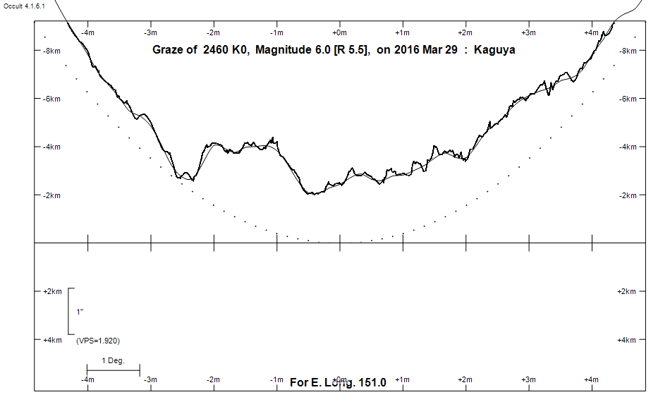
Graze profile
Grazing Occultation of    2460 K0      Magnitude 6.0 [Red = 5.5]
Date: 2016 Mar 29 17h 25m,  to  2016 Mar 29 18h 11m

Nominal site altitude 100m

E. Longit.   Latitude       U.T.    Sun  Moon   TanZ   PA    AA      CA
   o  '  "    o  '   "    h  m  s   Alt Alt Az          o     o      o
 135  0  0  -29 46 53.1  17 24 34       57  76  0.65 193.0 187.88  10.14S
 135 30  0  -29 57 24.5  17 25 42       58  75  0.63 192.9 187.80  10.06S
 136  0  0  -30  7 48.1  17 26 50       58  74  0.62 192.8 187.71   9.98S
 136 30  0  -30 18  3.9  17 27 58       59  73  0.60 192.7 187.62   9.89S
 137  0  0  -30 28 11.6  17 29  7       60  72  0.59 192.6 187.53   9.80S
 137 30  0  -30 38 11.0  17 30 15       60  71  0.57 192.5 187.44   9.71S
 138  0  0  -30 48  2.0  17 31 25       61  70  0.56 192.5 187.35   9.62S
 138 30  0  -30 57 44.3  17 32 34       61  69  0.55 192.4 187.25   9.52S
 139  0  0  -31  7 17.9  17 33 44       62  68  0.53 192.3 187.15   9.42S
 139 30  0  -31 16 42.5  17 34 54       62  67  0.52 192.2 187.05   9.32S
 140  0  0  -31 25 58.1  17 36  4       63  66  0.51 192.1 186.94   9.21S
 140 30  0  -31 35  4.4  17 37 14       64  64  0.50 191.9 186.84   9.10S
 141  0  0  -31 44  1.3  17 38 24       64  63  0.49 191.8 186.73   9.00S
 141 30  0  -31 52 48.7  17 39 35       65  62  0.47 191.7 186.61   8.88S
 142  0  0  -32  1 26.5  17 40 45       65  60  0.46 191.6 186.50   8.77S
 142 30  0  -32  9 54.5  17 41 56       66  59  0.45 191.5 186.38   8.65S
 143  0  0  -32 18 12.7  17 43  7       66  58  0.44 191.4 186.26   8.53S
 143 30  0  -32 26 20.8  17 44 18       67  56  0.43 191.3 186.14   8.41S
 144  0  0  -32 34 18.9  17 45 29       67  54  0.42 191.1 186.02   8.29S
 144 30  0  -32 42  6.7  17 46 40       68  53  0.41 191.0 185.90   8.17S
 145  0  0  -32 49 44.3  17 47 51       68  51  0.40 190.9 185.77   8.04S
 145 30  0  -32 57 11.5  17 49  2       68  49  0.39 190.7 185.64   7.91S
 146  0  0  -33  4 28.3  17 50 13       69  48  0.39 190.6 185.51   7.78S
 146 30  0  -33 11 34.5  17 51 25       69  46  0.38 190.5 185.38   7.65S
 147  0  0  -33 18 30.2  17 52 36       70  44  0.37 190.4 185.24   7.51S
 147 30  0  -33 25 15.2  17 53 47       70  42  0.36 190.2 185.11   7.38S
 148  0  0  -33 31 49.5  17 54 58       70  40  0.36 190.1 184.97   7.24S
 148 30  0  -33 38 13.0  17 56  9       71  38  0.35 189.9 184.83   7.10S
 149  0  0  -33 44 25.7  17 57 20       71  36  0.34 189.8 184.69   6.96S
 149 30  0  -33 50 27.5  17 58 30       71  33  0.34 189.7 184.55   6.82S
 150  0  0  -33 56 18.5  17 59 41       72  31  0.33 189.5 184.40   6.67S
 150 30  0  -34  1 58.5  18  0 52       72  29  0.33 189.4 184.26   6.53S
 151  0  0  -34  7 27.6  18  2  2       72  26  0.32 189.2 184.11   6.38S
 151 30  0  -34 12 45.7  18  3 13       72  24  0.32 189.1 183.97   6.24S
 152  0  0  -34 17 52.8  18  4 23       72  21  0.32 188.9 183.82   6.09S
 152 30  0  -34 22 48.9  18  5 33       73  19  0.31 188.8 183.67   5.94S
 153  0  0  -34 27 33.9  18  6 43       73  16  0.31 188.6 183.52   5.79S
 153 30  0  -34 32  7.9  18  7 53       73  14  0.31 188.5 183.37   5.64S
 154  0  0  -34 36 30.8  18  9  3       73  11  0.31 188.3 183.22   5.49S
 154 30  0  -34 40 42.7  18 10 13       73   9  0.31 188.2 183.07   5.34S
 155  0  0  -34 44 43.6  18 11 22       73   6  0.31 188.0 182.91   5.19S

Path coordinates are referred to WGS84 (as used by GPS), with the
nominal site altitude being referenced to Mean Sea Level. The path
is adjusted for the effects of refraction at low moon altitudes.

Projected diameter of star  2 meters  [Estimated]


    C A S S I N I   R E G I O N   G R A Z E
                Librations  Long -6.01   Lat -7.05
                            P +186.49     D -6.15
      Illumination of moon  68%-
        Elongation of Moon  111
    Vertical Profile Scale  approx. 1.95 km/arcsec at mean distance of moon
   Horizontal Scale Factor  1.22 deg/min


At longitude 145.00:
Limiting Magnitudes for various telescope apertures (in cm)
      CA\Tdia   5    10    15    20    25    30    35
     4.0      4.9   6.3   7.1   7.7   8.0   8.3   8.5
     6.0      5.7   7.2   8.0   8.6   8.9   9.2   9.4
     8.0      5.8   7.2   8.0   8.6   8.9   9.2   9.4
    10.0      5.8   7.2   8.0   8.6   9.0   9.2   9.5
    12.0      5.8   7.2   8.1   8.6   9.0   9.3   9.5

------------------------------------------------------------------------------
Results of Observer Scan                                    UT
Site                              Long.   Lat.   Dist.    h  m  s
AU Mid                            143.0  -30.6   181km   17 43  7.1
Canberra                          149.2  -35.3   163km   17 57 40.9
Newcastle                         151.7  -33.0   142km   18  3 43.4
Sydney                            151.1  -33.8    33km   18  2 11.9
Lunar Limb Profile