Predictions for Grazing Occultation of ZC2690, 2016 Apr 27
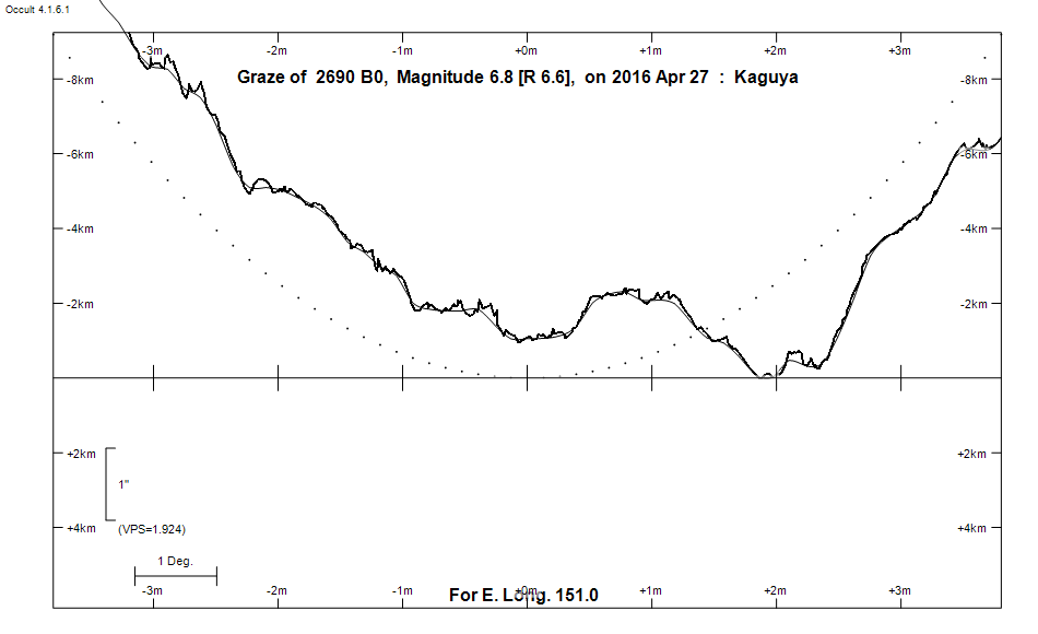
Graze profile
Grazing Occultation of    2690 B0      Magnitude 6.8 [Red = 6.6]  v
Date: 2016 Apr 27 13h 59m,  to  2016 Apr 27 14h 21m

Nominal site altitude 100m

E. Longit.   Latitude       U.T.    Sun  Moon   TanZ   PA    AA      CA
   o  '  "    o  '   "    h  m  s   Alt Alt Az          o     o      o
 135  0  0  -18 24 10.3  13 58 48       17 104  3.32 186.6 190.49  12.87S
 135 30  0  -18 34 54.3  13 59  7       17 104  3.20 186.6 190.49  12.87S
 136  0  0  -18 45 38.8  13 59 27       18 104  3.09 186.6 190.50  12.88S
 136 30  0  -18 56 23.3  13 59 48       19 104  2.99 186.6 190.50  12.88S
 137  0  0  -19  7  7.9  14  0 10       19 103  2.89 186.6 190.50  12.88S
 137 30  0  -19 17 52.3  14  0 32       20 103  2.80 186.6 190.50  12.88S
 138  0  0  -19 28 36.6  14  0 55       20 103  2.71 186.6 190.49  12.87S
 138 30  0  -19 39 20.5  14  1 19       21 103  2.63 186.6 190.49  12.87S
 139  0  0  -19 50  4.0  14  1 44       21 103  2.55 186.6 190.49  12.87S
 139 30  0  -20  0 47.0  14  2  9       22 102  2.47 186.6 190.48  12.86S
 140  0  0  -20 11 29.4  14  2 35       23 102  2.40 186.6 190.47  12.85S
 140 30  0  -20 22 11.0  14  3  1       23 102  2.33 186.6 190.47  12.85S
 141  0  0  -20 32 51.8  14  3 29       24 102  2.26 186.5 190.46  12.84S
 141 30  0  -20 43 31.6  14  3 57       24 101  2.20 186.5 190.45  12.83S
 142  0  0  -20 54 10.3  14  4 25       25 101  2.14 186.5 190.43  12.81S
 142 30  0  -21  4 47.8  14  4 55       26 101  2.08 186.5 190.42  12.80S
 143  0  0  -21 15 23.9  14  5 25       26 101  2.03 186.5 190.41  12.79S
 143 30  0  -21 25 58.5  14  5 56       27 100  1.97 186.5 190.39  12.77S
 144  0  0  -21 36 31.6  14  6 27       27 100  1.92 186.5 190.37  12.75S
 144 30  0  -21 47  2.9  14  7  0       28 100  1.87 186.4 190.35  12.73S
 145  0  0  -21 57 32.3  14  7 33       29 100  1.83 186.4 190.33  12.71S
 145 30  0  -22  7 59.7  14  8  6       29  99  1.78 186.4 190.31  12.69S
 146  0  0  -22 18 24.9  14  8 41       30  99  1.74 186.4 190.29  12.67S
 146 30  0  -22 28 47.9  14  9 16       31  99  1.69 186.4 190.27  12.65S
 147  0  0  -22 39  8.4  14  9 52       31  98  1.65 186.3 190.24  12.62S
 147 30  0  -22 49 26.4  14 10 29       32  98  1.61 186.3 190.21  12.59S
 148  0  0  -22 59 41.7  14 11  6       32  98  1.58 186.3 190.18  12.56S
 148 30  0  -23  9 54.0  14 11 44       33  98  1.54 186.2 190.15  12.53S
 149  0  0  -23 20  3.4  14 12 23       34  97  1.50 186.2 190.12  12.50S
 149 30  0  -23 30  9.6  14 13  2       34  97  1.47 186.2 190.08  12.46S
 150  0  0  -23 40 12.5  14 13 43       35  97  1.43 186.1 190.05  12.43S
 150 30  0  -23 50 11.9  14 14 23       36  96  1.40 186.1 190.00  12.38S
 151  0  0  -24  0  7.6  14 15  5       36  96  1.37 186.0 189.96  12.34S
 151 30  0  -24  9 59.6  14 15 47       37  96  1.34 186.0 189.91  12.30S
 152  0  0  -24 19 47.7  14 16 30       37  95  1.31 186.0 189.87  12.25S
 152 30  0  -24 29 31.6  14 17 14       38  95  1.28 185.9 189.82  12.20S
 153  0  0  -24 39 11.3  14 17 58       39  94  1.25 185.9 189.77  12.16S
 153 30  0  -24 48 46.6  14 18 43       39  94  1.22 185.8 189.72  12.11S
 154  0  0  -24 58 17.2  14 19 29       40  94  1.19 185.8 189.67  12.05S
 154 30  0  -25  7 43.2  14 20 16       41  93  1.17 185.7 189.62  12.00S
 155  0  0  -25 17  4.2  14 21  3       41  93  1.14 185.6 189.56  11.94S

Path coordinates are referred to WGS84 (as used by GPS), with the
nominal site altitude being referenced to Mean Sea Level. The path
is adjusted for the effects of refraction at low moon altitudes.

2690 is variable:
      2690 = V4398 Sgr, 6.89 to 6.93, Hp, Type ACYG, Period 2.42048 days, Phase 18 %


                Librations  Long -5.76   Lat -6.55
                            P +190.96     D -5.15
      Illumination of moon  75%-
        Elongation of Moon  119
    Vertical Profile Scale  approx. 1.91 km/arcsec at mean distance of moon
   Horizontal Scale Factor  1.62 deg/min


At longitude 145.00:
Limiting Magnitudes for various telescope apertures (in cm)
      CA\Tdia   5    10    15    20    25    30    35
     8.7      5.4   6.8   7.5   8.0   8.3   8.5   8.7
    10.7      5.4   6.8   7.6   8.0   8.3   8.5   8.7
    12.7      5.4   6.8   7.6   8.0   8.3   8.6   8.7
    14.7      5.4   6.8   7.6   8.0   8.4   8.6   8.7
    16.7      5.4   6.8   7.6   8.1   8.4   8.6   8.7

------------------------------------------------------------------------------
Results of Observer Scan                                    UT
Site                              Long.   Lat.   Dist.    h  m  s
Brisbane                          153.1  -27.5   292km   14 18  3.0
Bundaberg                         152.3  -24.8    38km   14 16 59.5
Rockhampton                       150.5  -23.4    49km   14 14 23.5
Lunar Limb Profile