Predictions for Grazing Occultation of ZC3270, 2016 May 1
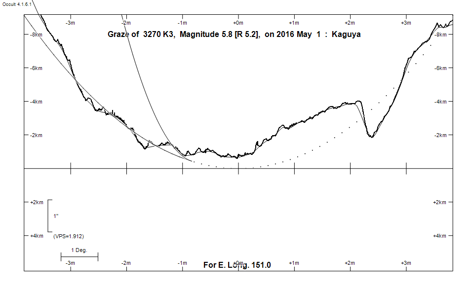
Graze profile
Grazing Occultation of    3270 K3      Magnitude 5.8 [Red = 5.2]
Date: 2016 May 01 18h 24m,  to  2016 May 01 18h 46m

Nominal site altitude 100m

E. Longit.   Latitude       U.T.    Sun  Moon   TanZ   PA    AA      CA
   o  '  "    o  '   "    h  m  s   Alt Alt Az          o     o      o
 135  0  0  -33 21 39.7  18 23 56       27  83  1.95 164.1 186.62   4.42S
 135 30  0  -33 21 53.7  18 24 19       28  82  1.91 164.0 186.53   4.34S
 136  0  0  -33 22  1.6  18 24 42       28  82  1.87 163.9 186.45   4.26S
 136 30  0  -33 22  3.1  18 25  6       29  82  1.83 163.9 186.36   4.17S
 137  0  0  -33 21 58.4  18 25 30       29  81  1.80 163.8 186.28   4.09S
 137 30  0  -33 21 47.2  18 25 54       30  81  1.76 163.7 186.19   4.00S
 138  0  0  -33 21 29.6  18 26 19       30  81  1.73 163.6 186.10   3.91S
 138 30  0  -33 21  5.4  18 26 45       31  80  1.69 163.5 186.01   3.82S
 139  0  0  -33 20 34.7  18 27 11       31  80  1.66 163.4 185.92   3.73S
 139 30  0  -33 19 57.3  18 27 37       32  79  1.63 163.3 185.83   3.64S
 140  0  0  -33 19 13.1  18 28  4       32  79  1.59 163.2 185.74   3.55S
 140 30  0  -33 18 22.2  18 28 32       33  79  1.56 163.1 185.64   3.45S
 141  0  0  -33 17 24.3  18 29  0       33  78  1.53 163.0 185.55   3.36S
 141 30  0  -33 16 19.5  18 29 29       34  78  1.50 162.9 185.45   3.26S
 142  0  0  -33 15  7.7  18 29 58       34  77  1.47 162.8 185.36   3.17S
 142 30  0  -33 13 48.8  18 30 27       35  77  1.45 162.7 185.26   3.07S
 143  0  0  -33 12 22.7  18 30 57       35  77  1.42 162.7 185.16   2.97S
 143 30  0  -33 10 49.3  18 31 28       36  76  1.39 162.6 185.06   2.87S
 144  0  0  -33  9  8.6  18 31 59       36  76  1.37 162.5 184.96   2.77S
 144 30  0  -33  7 20.4  18 32 31       37  75  1.34 162.4 184.86   2.67S
 145  0  0  -33  5 24.8  18 33  3       37  75  1.31 162.2 184.76   2.57S
 145 30  0  -33  3 21.6  18 33 36       38  75  1.29 162.1 184.66   2.46S
 146  0  0  -33  1 10.8  18 34  9       38  74  1.27 162.0 184.55   2.36S
 146 30  0  -32 58 52.2  18 34 43       39  74  1.24 161.9 184.44   2.25S
 147  0  0  -32 56 25.7  18 35 17       39  73  1.22 161.8 184.34   2.15S
 147 30  0  -32 53 51.4  18 35 52       40  73  1.20 161.7 184.23   2.04S
 148  0  0  -32 51  9.1  18 36 28       40  72  1.17 161.6 184.12   1.93S
 148 30  0  -32 48 18.7  18 37  4       41  72  1.15 161.5 184.02   1.83S
 149  0  0  -32 45 20.1  18 37 40       42  71  1.13 161.4 183.91   1.72S
 149 30  0  -32 42 13.2  18 38 18       42  71  1.11 161.3 183.80   1.61S
 150  0  0  -32 38 58.0  18 38 56       43  70  1.09 161.2 183.68   1.49S
 150 30  0  -32 35 34.4  18 39 34       43  70  1.07 161.1 183.57   1.38S
 151  0  0  -32 32  2.3  18 40 13       44  69  1.05 160.9 183.45   1.26S
 151 30  0  -32 28 21.5  18 40 53       44  69  1.03 160.8 183.34   1.15S
 152  0  0  -32 24 32.0  18 41 33       45  68  1.01 160.7 183.22   1.03S
 152 30  0  -32 20 33.7  18 42 14       45  68  0.99 160.6 183.10   0.91S
 153  0  0  -32 16 26.4  18 42 55       46  67  0.97 160.5 182.98   0.79S
 153 30  0  -32 12 10.2  18 43 37       46  67  0.95 160.3 182.86   0.67S
 154  0  0  -32  7 44.9  18 44 20       47  66  0.93 160.2 182.74   0.55S
 154 30  0  -32  3 10.3  18 45  3       48  66  0.91 160.1 182.61   0.42S
 155  0  0  -31 58 26.5  18 45 47       48  65  0.90 160.0 182.49   0.30S

Path coordinates are referred to WGS84 (as used by GPS), with the
nominal site altitude being referenced to Mean Sea Level. The path
is adjusted for the effects of refraction at low moon altitudes.

Projected diameter of star  3 meters  [Estimated]


    C A S S I N I   R E G I O N   G R A Z E
                Librations  Long -6.00   Lat -2.22
                            P +184.94     D -1.46
      Illumination of moon  32%-
        Elongation of Moon  69
    Vertical Profile Scale  approx. 1.93 km/arcsec at mean distance of moon
   Horizontal Scale Factor  1.59 deg/min


At longitude 145.00:
Limiting Magnitudes for various telescope apertures (in cm)
      CA\Tdia   5    10    15    20    25    30    35
    -1.4      3.3   4.7   5.4   5.9   6.2   6.4   6.5
     0.6      5.1   6.5   7.3   7.8   8.2   8.4   8.6
     2.6      5.1   6.5   7.3   7.8   8.2   8.4   8.6
     4.6      5.1   6.5   7.3   7.8   8.2   8.4   8.6
     6.6      5.9   7.4   8.2   8.7   9.1   9.4   9.6

------------------------------------------------------------------------------
Results of Observer Scan                                    UT
Site                              Long.   Lat.   Dist.    h  m  s
Adelaide                          138.6  -34.6   137km   18 26 50.2
Albany                            117.8  -35.0   297km   18 15 23.6
AU Mid                            143.0  -30.6   289km   18 30 57.3
Canberra                          149.2  -35.3   280km   18 37 51.6
Newcastle                         151.7  -33.0    55km   18 41 10.1
Perth                             115.9  -32.0    14km   18 14 55.2
Pt Macquarie                      152.8  -31.4    98km   18 42 41.4
Sydney                            151.1  -33.8   143km   18 40 18.3
Lunar Limb Profile