Predictions for Grazing Occultation of ZC2647, 2016 May 24
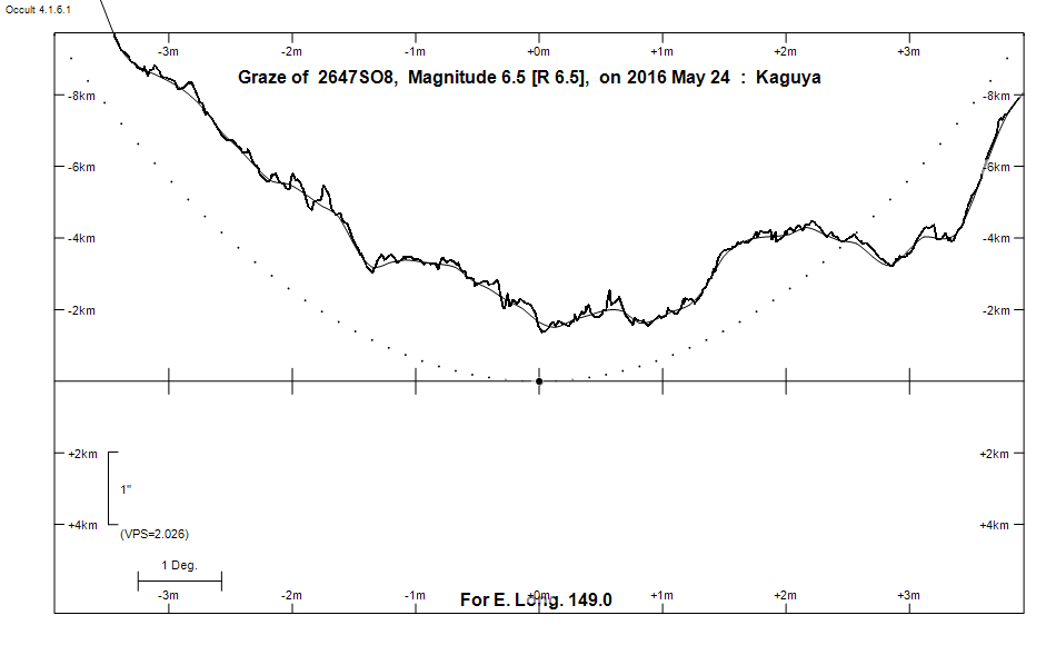
Graze profile
Grazing Occultation of    2647SO8      Magnitude 6.5 [Red = 6.5]
Date: 2016 May 24 12h 39m,  to  2016 May 24 13h  8m

Nominal site altitude 100m

E. Longit.   Latitude       U.T.    Sun  Moon   TanZ   PA    AA      CA
   o  '  "    o  '   "    h  m  s   Alt Alt Az          o     o      o
 135  0  0  -29 47 39.3  12 38 42       28  96  1.86 187.5 189.75  17.93S
 135 30  0  -29 58 31.2  12 39 15       29  96  1.82 187.4 189.73  17.92S
 136  0  0  -30  9 21.2  12 39 48       29  95  1.78 187.4 189.71  17.90S
 136 30  0  -30 20  9.0  12 40 22       30  95  1.74 187.4 189.69  17.88S
 137  0  0  -30 30 54.6  12 40 57       31  95  1.70 187.4 189.67  17.86S
 137 30  0  -30 41 37.7  12 41 32       31  94  1.66 187.4 189.65  17.83S
 138  0  0  -30 52 18.2  12 42  8       32  94  1.62 187.3 189.62  17.81S
 138 30  0  -31  2 56.1  12 42 44       32  93  1.59 187.3 189.60  17.78S
 139  0  0  -31 13 31.1  12 43 21       33  93  1.55 187.3 189.57  17.75S
 139 30  0  -31 24  3.1  12 43 59       33  93  1.52 187.2 189.54  17.73S
 140  0  0  -31 34 32.0  12 44 37       34  92  1.49 187.2 189.51  17.69S
 140 30  0  -31 44 57.5  12 45 16       35  92  1.45 187.2 189.48  17.66S
 141  0  0  -31 55 19.6  12 45 56       35  91  1.42 187.1 189.44  17.63S
 141 30  0  -32  5 38.2  12 46 36       36  91  1.39 187.1 189.41  17.59S
 142  0  0  -32 15 53.0  12 47 16       36  90  1.37 187.1 189.37  17.56S
 142 30  0  -32 26  4.0  12 47 57       37  90  1.34 187.0 189.33  17.52S
 143  0  0  -32 36 10.9  12 48 39       37  89  1.31 187.0 189.29  17.48S
 143 30  0  -32 46 13.6  12 49 21       38  89  1.28 187.0 189.25  17.44S
 144  0  0  -32 56 12.1  12 50  4       38  88  1.26 186.9 189.21  17.39S
 144 30  0  -33  6  6.0  12 50 48       39  88  1.23 186.9 189.16  17.35S
 145  0  0  -33 15 55.3  12 51 31       40  87  1.21 186.8 189.11  17.30S
 145 30  0  -33 25 39.9  12 52 16       40  87  1.18 186.8 189.07  17.25S
 146  0  0  -33 35 19.6  12 53  1       41  86  1.16 186.7 189.02  17.20S
 146 30  0  -33 44 54.3  12 53 46       41  86  1.14 186.7 188.96  17.15S
 147  0  0  -33 54 23.7  12 54 32       42  85  1.12 186.6 188.91  17.10S
 147 30  0  -34  3 47.9  12 55 18       42  84  1.09 186.6 188.85  17.04S
 148  0  0  -34 13  6.6  12 56  5       43  84  1.07 186.5 188.80  16.99S
 148 30  0  -34 22 19.7  12 56 52       44  83  1.05 186.4 188.74  16.93S
 149  0  0  -34 31 27.1  12 57 40       44  83  1.03 186.4 188.68  16.87S
 149 30  0  -34 40 28.6  12 58 28       45  82  1.01 186.3 188.62  16.81S
 150  0  0  -34 49 24.1  12 59 17       45  81  0.99 186.3 188.55  16.74S
 150 30  0  -34 58 13.6  13  0  6       46  81  0.97 186.2 188.49  16.68S
 151  0  0  -35  6 56.8  13  0 56       46  80  0.96 186.1 188.42  16.61S
 151 30  0  -35 15 33.6  13  1 46       47  79  0.94 186.1 188.35  16.54S
 152  0  0  -35 24  4.0  13  2 36       47  79  0.92 186.0 188.28  16.47S
 152 30  0  -35 32 27.6  13  3 27       48  78  0.90 185.9 188.21  16.40S
 153  0  0  -35 40 44.6  13  4 18       48  77  0.89 185.8 188.13  16.33S
 153 30  0  -35 48 54.6  13  5  9       49  77  0.87 185.8 188.06  16.25S
 154  0  0  -35 56 57.7  13  6  1       50  76  0.85 185.7 187.98  16.17S
 154 30  0  -36  4 53.7  13  6 53       50  75  0.84 185.6 187.90  16.09S
 155  0  0  -36 12 42.6  13  7 46       51  74  0.82 185.5 187.82  16.01S

Path coordinates are referred to WGS84 (as used by GPS), with the
nominal site altitude being referenced to Mean Sea Level. The path
is adjusted for the effects of refraction at low moon altitudes.

2647 is triple:
  This next pair is not confirmed
  **Aa,Ab 7.2 7.2 0.10" 270.0 (OCc  12) Graze path of ? approximately 0.0 km north, and 0.2 secs earlier compared to the primary
  - refer to graze profile for exact distances
  AB 6.5 13.0 8.5" 168.9 (RST3170) Graze path of B approximately 15.7 km north, and 6.5 secs later compared to A
  - refer to graze profile for exact distances

                Librations  Long -4.58   Lat -6.63
                            P +189.64     D -5.56
      Illumination of moon  93%-
        Elongation of Moon  149
    Vertical Profile Scale  approx. 2.00 km/arcsec at mean distance of moon
   Horizontal Scale Factor  1.53 deg/min


At longitude 145.00:
Limiting Magnitudes for various telescope apertures (in cm)
      CA\Tdia   5    10    15    20    25    30    35
    13.3      4.7   6.1   6.8   7.3   7.6   7.9   8.0
    15.3      5.1   6.5   7.3   7.8   8.1   8.3   8.5
    17.3      5.4   6.8   7.6   8.1   8.4   8.6   8.8
    19.3      5.4   6.8   7.6   8.1   8.4   8.6   8.8
    21.3      5.4   6.8   7.6   8.1   8.4   8.6   8.8

------------------------------------------------------------------------------

Results of Observer Scan                                    UT
Site                              Long.   Lat.   Dist.    h  m  s
AU Mid                            143.0  -30.6   207km   12 48 39.3
Canberra                          149.2  -35.3    74km   12 57 54.7
Newcastle                         151.7  -33.0   250km   13  2  7.5
Sydney                            151.1  -33.8   137km   13  1  2.5
Lunar Limb Profile