Predictions for Grazing Occultation of SAO146389, 2016 May 29
Graze profile
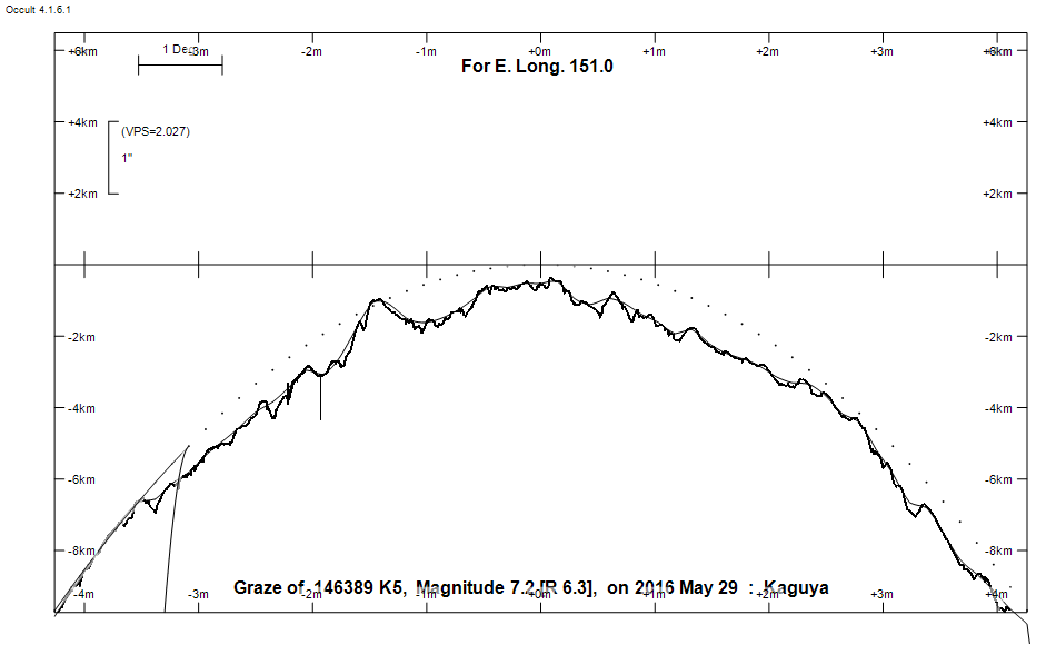
Grazing Occultation of  146389 K5      Magnitude 7.2 [Red = 6.3]  s
Date: 2016 May 29 19h 13m,  to  2016 May 29 19h 57m

Nominal site altitude 100m

E. Longit.   Latitude       U.T.    Sun  Moon   TanZ   PA    AA      CA
   o  '  "    o  '   "    h  m  s   Alt Alt Az          o     o      o
 135  0  0  -39 13 59.2  19 13 29       45  50  0.99 337.0   1.01   0.58N
 135 30  0  -39  6 36.1  19 14 20       46  50  0.97 336.9   0.89   0.69N
 136  0  0  -38 59  3.5  19 15 11       46  49  0.96 336.8   0.78   0.80N
 136 30  0  -38 51 21.1  19 16  2       47  48  0.94 336.7   0.67   0.92N
 137  0  0  -38 43 29.0  19 16 55       47  47  0.92 336.5   0.55   1.03N
 137 30  0  -38 35 27.0  19 17 48       48  47  0.91 336.4   0.44   1.14N
 138  0  0  -38 27 15.1  19 18 42       48  46  0.89 336.3   0.32   1.26N
 138 30  0  -38 18 53.1  19 19 37       49  45  0.88 336.2   0.21   1.37N
 139  0  0  -38 10 20.9  19 20 33       49  44  0.86 336.1   0.09   1.49N
 139 30  0  -38  1 38.4  19 21 29       50  43  0.85 336.0 359.99   1.59N
 140  0  0  -37 52 45.5  19 22 27       50  43  0.83 335.9 359.87   1.71N
 140 30  0  -37 43 42.2  19 23 25       51  42  0.82 335.7 359.76   1.82N
 141  0  0  -37 34 28.4  19 24 24       51  41  0.80 335.6 359.64   1.94N
 141 30  0  -37 25  3.9  19 25 23       52  40  0.79 335.5 359.53   2.06N
 142  0  0  -37 15 28.7  19 26 24       52  39  0.77 335.4 359.41   2.17N
 142 30  0  -37  5 42.6  19 27 25       53  38  0.76 335.3 359.29   2.29N
 143  0  0  -36 55 45.7  19 28 27       53  37  0.75 335.2 359.18   2.40N
 143 30  0  -36 45 37.8  19 29 30       54  36  0.73 335.0 359.06   2.52N
 144  0  0  -36 35 18.8  19 30 34       54  35  0.72 334.9 358.95   2.64N
 144 30  0  -36 24 48.7  19 31 39       55  34  0.71 334.8 358.83   2.75N
 145  0  0  -36 14  7.4  19 32 44       55  33  0.69 334.7 358.71   2.87N
 145 30  0  -36  3 14.8  19 33 51       56  32  0.68 334.6 358.60   2.98N
 146  0  0  -35 52 10.8  19 34 58       56  31  0.67 334.5 358.48   3.10N
 146 30  0  -35 40 55.5  19 36  6       57  30  0.66 334.4 358.37   3.21N
 147  0  0  -35 29 28.8  19 37 15       57  28  0.64 334.2 358.25   3.33N
 147 30  0  -35 17 50.6  19 38 24       58  27  0.63 334.1 358.14   3.44N
 148  0  0  -35  6  0.9  19 39 35       58  26  0.62 334.0 358.03   3.55N
 148 30  0  -34 53 59.6  19 40 46       59  25  0.61 333.9 357.92   3.67N
 149  0  0  -34 41 46.9  19 41 58       59  23  0.60 333.8 357.81   3.78N
 149 30  0  -34 29 22.6  19 43 11       60  22  0.59 333.7 357.70   3.89N
 150  0  0  -34 16 46.7  19 44 25       60  21  0.58 333.6 357.59   4.00N
 150 30  0  -34  3 59.3  19 45 40       60  19  0.57 333.5 357.48   4.10N
 151  0  0  -33 51  0.5  19 46 55       61  18  0.56 333.4 357.37   4.21N
 151 30  0  -33 37 50.1  19 48 11       61  16  0.55 333.3 357.27   4.31N
 152  0  0  -33 24 28.4  19 49 28  -12  62  15  0.54 333.1 357.17   4.42N
 152 30  0  -33 10 55.3  19 50 46  -11  62  13  0.53 333.0 357.06   4.52N
 153  0  0  -32 57 10.9  19 52  5  -10  62  11  0.52 332.9 356.96   4.62N
 153 30  0  -32 43 15.3  19 53 24  -10  63  10  0.52 332.8 356.87   4.72N
 154  0  0  -32 29  8.7  19 54 44   -9  63   8  0.51 332.8 356.77   4.81N
 154 30  0  -32 14 51.0  19 56  4   -8  63   6  0.50 332.7 356.68   4.91N
 155  0  0  -32  0 22.6  19 57 25   -7  64   4  0.49 332.6 356.59   5.00N

Path coordinates are referred to WGS84 (as used by GPS), with the
nominal site altitude being referenced to Mean Sea Level. The path
is adjusted for the effects of refraction at low moon altitudes.

Projected diameter of star  4 meters  [Estimated]

146389 is variable:
    146389 = NSV 25974, 7.27 to 7.31, Hp


                Librations  Long -5.41   Lat -0.96
                            P +358.83     D +1.34
      Illumination of moon  46%-
        Elongation of Moon  86
    Vertical Profile Scale  approx. 2.04 km/arcsec at mean distance of moon
   Horizontal Scale Factor  1.40 deg/min


At longitude 145.00:
Limiting Magnitudes for various telescope apertures (in cm)
      CA\Tdia   5    10    15    20    25    30    35
    -1.1      3.2   4.6   5.4   5.9   6.2   6.4   6.6
     0.9      5.0   6.5   7.3   7.8   8.2   8.5   8.7
     2.9      5.1   6.5   7.3   7.8   8.2   8.5   8.7
     4.9      5.9   7.4   8.2   8.7   9.1   9.4   9.6
     6.9      5.9   7.4   8.2   8.7   9.1   9.4   9.6

------------------------------------------------------------------------------
Results of Observer Scan                                    UT
Site                              Long.   Lat.   Dist.    h  m  s
Newcastle                         151.7  -33.0    57km   19 48 44.8
Pt Macquarie                      152.8  -31.4   159km   19 51 38.4
Sydney                            151.1  -33.8     1km   19 47  5.4
Lunar Limb Profile