Predictions for Grazing Occultation of ZC2279, 2016 Jul 15
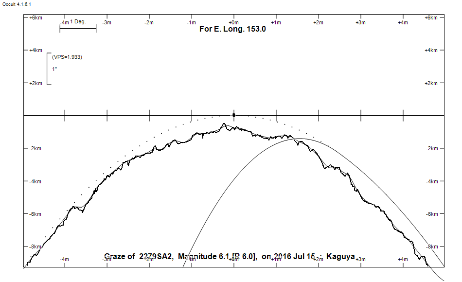
Graze profile
Grazing Occultation of    2279SA2      Magnitude 6.1 [Red = 6.0]  v
Date: 2016 Jul 15  8h 57m,  to  2016 Jul 15  9h 57m

Nominal site altitude 100m

E. Longit.   Latitude       U.T.    Sun  Moon   TanZ   PA    AA      CA
   o  '  "    o  '   "    h  m  s   Alt Alt Az          o     o      o
 135  0  0  -22 19  2.1   8 56 33   -6  55  85  0.71  21.7   9.50   5.96N
 135 30  0  -22 33 56.6   8 57 51   -7  55  84  0.69  21.6   9.49   5.95N
 136  0  0  -22 48 48.4   8 59 11   -7  56  83  0.67  21.6   9.47   5.93N
 136 30  0  -23  3 37.4   9  0 31   -8  57  82  0.65  21.6   9.45   5.91N
 137  0  0  -23 18 23.0   9  1 53   -9  58  81  0.64  21.6   9.42   5.88N
 137 30  0  -23 33  4.9   9  3 15  -10  58  80  0.62  21.5   9.39   5.85N
 138  0  0  -23 47 42.6   9  4 39  -11  59  79  0.60  21.5   9.35   5.81N
 138 30  0  -24  2 15.7   9  6  3  -12  60  78  0.58  21.5   9.31   5.77N
 139  0  0  -24 16 44.0   9  7 28       60  77  0.57  21.4   9.27   5.73N
 139 30  0  -24 31  6.8   9  8 54       61  76  0.55  21.4   9.22   5.68N
 140  0  0  -24 45 23.9   9 10 21       62  75  0.54  21.3   9.17   5.63N
 140 30  0  -24 59 34.8   9 11 49       63  74  0.52  21.3   9.11   5.57N
 141  0  0  -25 13 39.2   9 13 17       63  73  0.50  21.2   9.05   5.51N
 141 30  0  -25 27 36.6   9 14 47       64  71  0.49  21.1   8.98   5.45N
 142  0  0  -25 41 26.7   9 16 16       65  70  0.48  21.1   8.92   5.38N
 142 30  0  -25 55  9.1   9 17 47       65  69  0.46  21.0   8.84   5.30N
 143  0  0  -26  8 43.4   9 19 18       66  67  0.45  20.9   8.76   5.22N
 143 30  0  -26 22  9.3   9 20 50       67  65  0.43  20.8   8.68   5.14N
 144  0  0  -26 35 26.4   9 22 22       67  64  0.42  20.7   8.59   5.06N
 144 30  0  -26 48 34.4   9 23 55       68  62  0.41  20.7   8.50   4.96N
 145  0  0  -27  1 32.9   9 25 28       68  60  0.40  20.6   8.41   4.87N
 145 30  0  -27 14 21.6   9 27  1       69  58  0.39  20.5   8.31   4.77N
 146  0  0  -27 27  0.3   9 28 35       69  56  0.37  20.4   8.20   4.67N
 146 30  0  -27 39 28.6   9 30 10       70  54  0.36  20.2   8.10   4.56N
 147  0  0  -27 51 46.2   9 31 44       71  52  0.35  20.1   7.98   4.45N
 147 30  0  -28  3 53.0   9 33 19       71  50  0.34  20.0   7.87   4.33N
 148  0  0  -28 15 48.6   9 34 54       71  47  0.34  19.9   7.75   4.21N
 148 30  0  -28 27 32.7   9 36 29       72  45  0.33  19.8   7.63   4.09N
 149  0  0  -28 39  5.3   9 38  5       72  42  0.32  19.7   7.50   3.96N
 149 30  0  -28 50 26.0   9 39 40       73  39  0.31  19.5   7.37   3.83N
 150  0  0  -29  1 34.6   9 41 16       73  37  0.31  19.4   7.23   3.70N
 150 30  0  -29 12 31.0   9 42 52       73  34  0.30  19.2   7.10   3.56N
 151  0  0  -29 23 15.1   9 44 27       74  31  0.29  19.1   6.96   3.42N
 151 30  0  -29 33 46.6   9 46  3       74  28  0.29  19.0   6.81   3.28N
 152  0  0  -29 44  5.4   9 47 38       74  25  0.29  18.8   6.67   3.13N
 152 30  0  -29 54 11.4   9 49 14       74  21  0.28  18.7   6.52   2.98N
 153  0  0  -30  4  4.5   9 50 49       74  18  0.28  18.5   6.37   2.83N
 153 30  0  -30 13 44.7   9 52 24       74  15  0.28  18.4   6.21   2.67N
 154  0  0  -30 23 11.7   9 53 59       74  12  0.28  18.2   6.05   2.52N
 154 30  0  -30 32 25.5   9 55 34       74   8  0.28  18.0   5.90   2.36N
 155  0  0  -30 41 26.1   9 57  8       74   5  0.28  17.9   5.73   2.20N

Path coordinates are referred to WGS84 (as used by GPS), with the
nominal site altitude being referenced to Mean Sea Level. The path
is adjusted for the effects of refraction at low moon altitudes.

2279 is variable:
      2279 = HR Lib, 6.12, range 0.02, V, Type DSCTC, Period 0.05886 days

2279 is triple:
  This next pair is not confirmed
  ** 7.0 7.0 0.10"  90.0 (OCc1485) Graze path of ? approximately 0.1 km south, and 0.3 secs later compared to the primary
  - refer to graze profile for exact distances
  AB 6.1 19.0 6.7"  77.0 (VIG  18) Graze path of B approximately 6.9 km south, and 17.9 secs later compared to A
  - refer to graze profile for exact distances

                Librations  Long -2.06   Lat -6.70
                            P +8.71     D +6.59
      Illumination of moon  80%+
        Elongation of Moon  127
    Vertical Profile Scale  approx. 1.93 km/arcsec at mean distance of moon
   Horizontal Scale Factor  1.20 deg/min


At longitude 145.00:
Limiting Magnitudes for various telescope apertures (in cm)
      CA\Tdia   5    10    15    20    25    30    35
     0.9      2.7   4.2   5.0   5.4   5.8   6.0   6.2
     2.9      3.8   5.3   6.0   6.6   6.9   7.2   7.3
     4.9      4.8   6.2   7.0   7.5   7.9   8.2   8.3
     6.9      4.8   6.3   7.1   7.6   8.0   8.2   8.4
     8.9      5.7   7.1   7.9   8.5   8.8   9.1   9.3

------------------------------------------------
AAVSO Variable star entry

       Variable identifier           Type        Max    Min  Ph  Epoch         Period
       HR Lib                        DSCTC       6.12 ( 0.02 V                  0.05886
------------------------------------------------------------------------------
Results of Observer Scan                                    UT
Site                              Long.   Lat.   Dist.    h  m  s
AU Mid                            143.0  -30.6   439km    9 19 18.1
Lunar Limb Profile