Predictions for Grazing Occultation of ZC2128, 2016 Aug 10
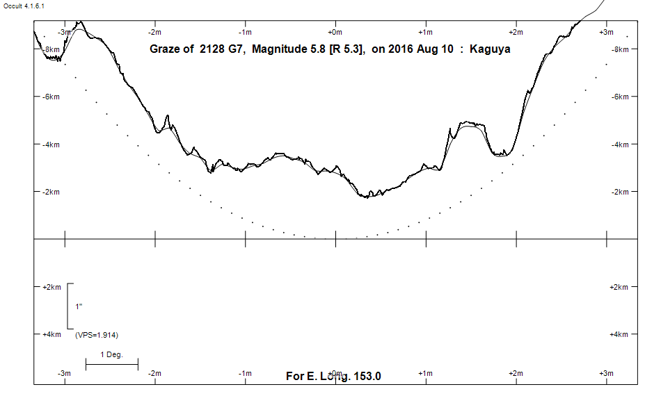
Graze profile
Grazing Occultation of    2128 G7      Magnitude 5.8 [Red = 5.3]
   R2128 = 13 Librae
Date: 2016 Aug 10 12h 32m,  to  2016 Aug 10 12h 46m

Nominal site altitude 100m

E. Longit.   Latitude       U.T.    Sun  Moon   TanZ   PA    AA      CA
   o  '  "    o  '   "    h  m  s   Alt Alt Az          o     o      o
 135  0  0  -28 35 10.1  12 31 40       33 274  1.53 192.9 175.44   3.52S
 135 30  0  -28 33 36.5  12 32 12       33 274  1.56 192.8 175.34   3.62S
 136  0  0  -28 31 56.1  12 32 44       32 273  1.59 192.7 175.24   3.72S
 136 30  0  -28 30  8.7  12 33 15       32 273  1.63 192.6 175.13   3.82S
 137  0  0  -28 28 14.7  12 33 46       31 273  1.66 192.5 175.04   3.92S
 137 30  0  -28 26 13.9  12 34 15       30 272  1.70 192.4 174.94   4.01S
 138  0  0  -28 24  6.6  12 34 45       30 272  1.74 192.3 174.84   4.11S
 138 30  0  -28 21 52.9  12 35 13       29 272  1.78 192.2 174.75   4.21S
 139  0  0  -28 19 32.7  12 35 42       29 272  1.82 192.1 174.65   4.30S
 139 30  0  -28 17  6.2  12 36  9       28 271  1.86 192.0 174.56   4.39S
 140  0  0  -28 14 33.6  12 36 36       28 271  1.90 192.0 174.47   4.48S
 140 30  0  -28 11 54.7  12 37  3       27 271  1.95 191.9 174.38   4.57S
 141  0  0  -28  9  9.9  12 37 28       27 270  1.99 191.8 174.30   4.66S
 141 30  0  -28  6 19.1  12 37 54       26 270  2.04 191.7 174.21   4.74S
 142  0  0  -28  3 22.4  12 38 18       26 270  2.09 191.6 174.13   4.83S
 142 30  0  -28  0 19.9  12 38 42       25 269  2.14 191.5 174.04   4.91S
 143  0  0  -27 57 11.8  12 39  6       25 269  2.19 191.4 173.96   4.99S
 143 30  0  -27 53 57.9  12 39 29       24 269  2.24 191.4 173.88   5.07S
 144  0  0  -27 50 38.6  12 39 51       23 268  2.30 191.3 173.80   5.15S
 144 30  0  -27 47 13.7  12 40 13       23 268  2.36 191.2 173.72   5.23S
 145  0  0  -27 43 43.5  12 40 35       22 268  2.42 191.1 173.65   5.31S
 145 30  0  -27 40  8.0  12 40 55       22 268  2.49 191.1 173.57   5.38S
 146  0  0  -27 36 27.2  12 41 16       21 267  2.55 191.0 173.50   5.45S
 146 30  0  -27 32 41.3  12 41 35       21 267  2.62 190.9 173.42   5.53S
 147  0  0  -27 28 50.2  12 41 54       20 267  2.70 190.8 173.35   5.60S
 147 30  0  -27 24 54.2  12 42 13       20 266  2.77 190.8 173.28   5.67S
 148  0  0  -27 20 53.2  12 42 31       19 266  2.85 190.7 173.21   5.74S
 148 30  0  -27 16 47.4  12 42 49       19 266  2.94 190.6 173.14   5.81S
 149  0  0  -27 12 36.8  12 43  6       18 266  3.02 190.6 173.08   5.87S
 149 30  0  -27  8 21.4  12 43 22       18 265  3.12 190.5 173.01   5.94S
 150  0  0  -27  4  1.5  12 43 38       17 265  3.21 190.4 172.95   6.01S
 150 30  0  -26 59 37.0  12 43 54       17 265  3.32 190.4 172.88   6.07S
 151  0  0  -26 55  7.9  12 44  9       16 265  3.43 190.3 172.82   6.13S
 151 30  0  -26 50 34.4  12 44 23       16 264  3.54 190.2 172.76   6.19S
 152  0  0  -26 45 56.5  12 44 37       15 264  3.67 190.2 172.70   6.25S
 152 30  0  -26 41 14.0  12 44 51       15 264  3.80 190.1 172.64   6.31S
 153  0  0  -26 36 27.6  12 45  4       14 264  3.94 190.1 172.58   6.37S
 153 30  0  -26 31 37.0  12 45 16       14 263  4.09 190.0 172.52   6.43S
 154  0  0  -26 26 42.3  12 45 28       13 263  4.25 190.0 172.47   6.48S
 154 30  0  -26 21 43.5  12 45 39       13 263  4.42 189.9 172.41   6.54S
 155  0  0  -26 16 40.8  12 45 50       12 263  4.60 189.8 172.36   6.59S

Path coordinates are referred to WGS84 (as used by GPS), with the
nominal site altitude being referenced to Mean Sea Level. The path
is adjusted for the effects of refraction at low moon altitudes.

Projected diameter of star  2 meters  [Estimated]


    C A S S I N I   R E G I O N   G R A Z E
                Librations  Long -1.88   Lat -6.13
                            P +173.81     D -6.04
      Illumination of moon  47%+
        Elongation of Moon  87
    Vertical Profile Scale  approx. 1.89 km/arcsec at mean distance of moon
   Horizontal Scale Factor  1.62 deg/min


At longitude 145.00:
Limiting Magnitudes for various telescope apertures (in cm)
      CA\Tdia   5    10    15    20    25    30    35
     1.3      4.7   6.1   6.8   7.2   7.5   7.7   7.8
     3.3      4.7   6.1   6.8   7.2   7.5   7.7   7.9
     5.3      5.4   6.9   7.6   8.1   8.4   8.6   8.7
     7.3      5.5   6.9   7.6   8.1   8.4   8.6   8.8
     9.3      5.5   6.9   7.6   8.1   8.4   8.6   8.8

------------------------------------------------------------------------------
Results of Observer Scan                                    UT
Site                              Long.   Lat.   Dist.    h  m  s
AU Mid                            143.0  -30.6   291km   12 39  5.8
Brisbane                          153.1  -27.5    95km   12 45  4.7
Lunar Limb Profile