Predictions for Grazing Occultation of ZC2647, 2016 Aug 14
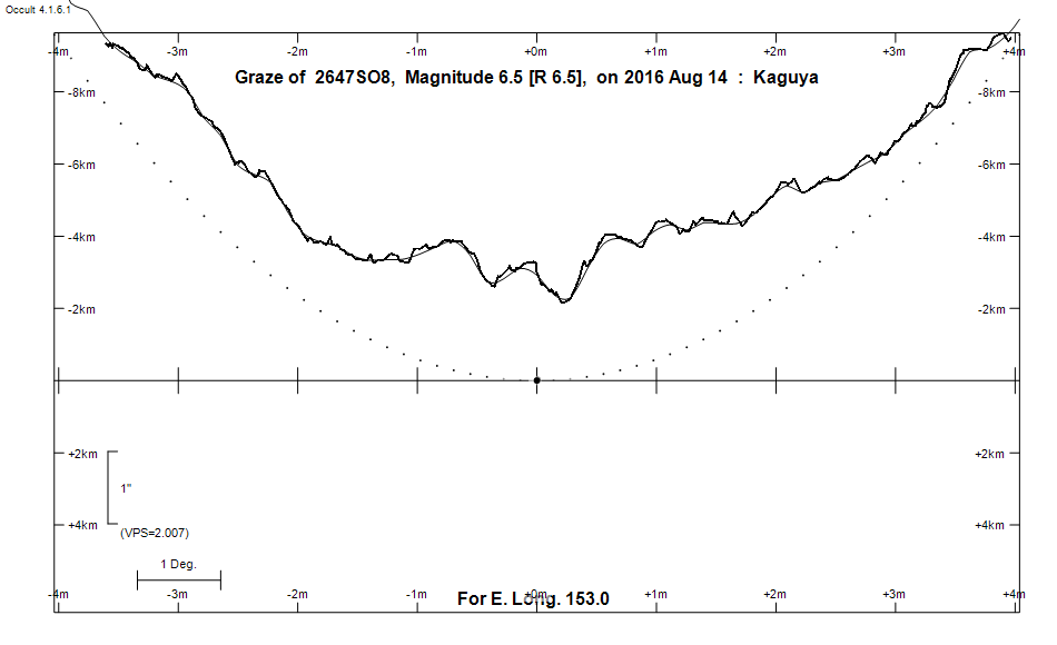
Graze profile, Adelaide
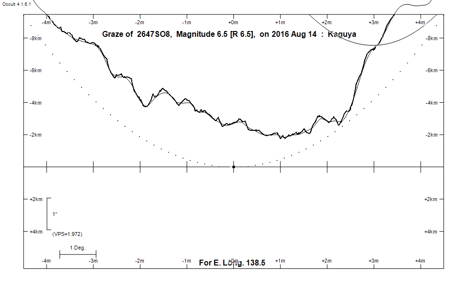
Graze profile, Port MacQuarie
Grazing Occultation of    2647SO8      Magnitude 6.5 [Red = 6.5]
Date: 2016 Aug 14 12h 59m,  to  2016 Aug 14 13h 37m

Nominal site altitude 100m

E. Longit.   Latitude       U.T.    Sun  Moon   TanZ   PA    AA      CA
   o  '  "    o  '   "    h  m  s   Alt Alt Az          o     o      o
 135  0  0  -35 27 29.0  12 58 43       67 311  0.43 176.7 179.12   6.10S
 135 30  0  -35 23 21.4  12 59 46       66 310  0.44 176.6 178.99   6.23S
 136  0  0  -35 19  3.9  13  0 49       66 308  0.45 176.5 178.86   6.36S
 136 30  0  -35 14 36.7  13  1 52       65 307  0.46 176.3 178.73   6.49S
 137  0  0  -35  9 59.7  13  2 54       65 305  0.47 176.2 178.60   6.62S
 137 30  0  -35  5 13.1  13  3 56       64 304  0.48 176.1 178.48   6.74S
 138  0  0  -35  0 16.9  13  4 59       64 303  0.49 176.0 178.35   6.87S
 138 30  0  -34 55 11.2  13  6  1       63 302  0.50 175.8 178.23   6.99S
 139  0  0  -34 49 56.0  13  7  3       63 300  0.51 175.7 178.11   7.11S
 139 30  0  -34 44 31.4  13  8  4       62 299  0.52 175.6 177.99   7.23S
 140  0  0  -34 38 57.5  13  9  6       62 298  0.54 175.5 177.87   7.35S
 140 30  0  -34 33 14.3  13 10  7       61 297  0.55 175.4 177.75   7.47S
 141  0  0  -34 27 21.9  13 11  8       61 296  0.56 175.3 177.64   7.58S
 141 30  0  -34 21 20.4  13 12  8       60 295  0.57 175.1 177.52   7.70S
 142  0  0  -34 15 10.0  13 13  9       60 294  0.58 175.0 177.41   7.81S
 142 30  0  -34  8 50.6  13 14  9       59 293  0.60 174.9 177.30   7.92S
 143  0  0  -34  2 22.3  13 15  9       59 292  0.61 174.8 177.19   8.03S
 143 30  0  -33 55 45.3  13 16  9       58 291  0.62 174.7 177.09   8.13S
 144  0  0  -33 48 59.7  13 17  8       58 290  0.63 174.6 176.98   8.24S
 144 30  0  -33 42  5.5  13 18  7       57 289  0.65 174.5 176.88   8.34S
 145  0  0  -33 35  2.9  13 19  6       57 288  0.66 174.4 176.78   8.44S
 145 30  0  -33 27 51.9  13 20  4       56 287  0.68 174.3 176.68   8.54S
 146  0  0  -33 20 32.7  13 21  2       55 286  0.69 174.2 176.58   8.64S
 146 30  0  -33 13  5.3  13 22  0       55 286  0.70 174.1 176.49   8.73S
 147  0  0  -33  5 30.0  13 22 58       54 285  0.72 174.0 176.39   8.82S
 147 30  0  -32 57 46.8  13 23 55       54 284  0.73 173.9 176.30   8.92S
 148  0  0  -32 49 55.7  13 24 51       53 283  0.75 173.8 176.21   9.01S
 148 30  0  -32 41 57.1  13 25 48       53 282  0.77 173.7 176.12   9.09S
 149  0  0  -32 33 50.9  13 26 44       52 282  0.78 173.7 176.04   9.18S
 149 30  0  -32 25 37.3  13 27 39       51 281  0.80 173.6 175.96   9.26S
 150  0  0  -32 17 16.4  13 28 34       51 280  0.82 173.5 175.87   9.34S
 150 30  0  -32  8 48.4  13 29 29       50 280  0.83 173.4 175.79   9.42S
 151  0  0  -32  0 13.4  13 30 23       50 279  0.85 173.3 175.72   9.50S
 151 30  0  -31 51 31.6  13 31 17       49 278  0.87 173.3 175.64   9.58S
 152  0  0  -31 42 43.0  13 32 10       48 278  0.89 173.2 175.57   9.65S
 152 30  0  -31 33 47.8  13 33  3       48 277  0.90 173.1 175.49   9.72S
 153  0  0  -31 24 46.2  13 33 55       47 276  0.92 173.0 175.43   9.79S
 153 30  0  -31 15 38.4  13 34 47       47 276  0.94 173.0 175.36   9.86S
 154  0  0  -31  6 24.4  13 35 39       46 275  0.96 172.9 175.29   9.92S
 154 30  0  -30 57  4.4  13 36 30       45 275  0.98 172.8 175.23   9.99S
 155  0  0  -30 47 38.5  13 37 20       45 274  1.00 172.8 175.17  10.05S

Path coordinates are referred to WGS84 (as used by GPS), with the
nominal site altitude being referenced to Mean Sea Level. The path
is adjusted for the effects of refraction at low moon altitudes.

2647 is triple:
  This next pair is not confirmed
  **Aa,Ab 7.2 7.2 0.10" 270.0 (OCc  12) Graze path of ? approximately 0.0 km south, and 0.3 secs earlier compared to the primary
  - refer to graze profile for exact distances
  AB 6.5 13.0 8.5" 168.9 (RST3170) Graze path of B approximately 16.2 km north, and 2.3 secs later compared to A
  - refer to graze profile for exact distances

    C A S S I N I   R E G I O N   G R A Z E
                Librations  Long -5.33   Lat -6.60
                            P +177.36     D -6.63
      Illumination of moon  83%+
        Elongation of Moon  132
    Vertical Profile Scale  approx. 1.96 km/arcsec at mean distance of moon
   Horizontal Scale Factor  1.35 deg/min


At longitude 145.00:
Limiting Magnitudes for various telescope apertures (in cm)
      CA\Tdia   5    10    15    20    25    30    35
     4.4      4.7   6.1   6.9   7.4   7.8   8.0   8.2
     6.4      4.7   6.1   6.9   7.4   7.8   8.0   8.2
     8.4      5.0   6.4   7.2   7.7   8.1   8.3   8.5
    10.4      5.6   7.0   7.8   8.4   8.7   9.0   9.2
    12.4      5.6   7.0   7.8   8.4   8.7   9.0   9.2

------------------------------------------------------------------------------
Results of Observer Scan                                    UT
Site                              Long.   Lat.   Dist.    h  m  s
Canberra                          149.2  -35.3   290km   13 27  0.2
Newcastle                         151.7  -33.0   121km   13 31 40.0
Pt Macquarie                      152.8  -31.4     7km   13 33 38.0
Sydney                            151.1  -33.8   194km   13 30 30.2
Lunar Limb Profile, Adelaide
Lunar Limb Profile, Port Macquarie