Predictions for Grazing Occultation of ZC1337, 2016 Oct 23
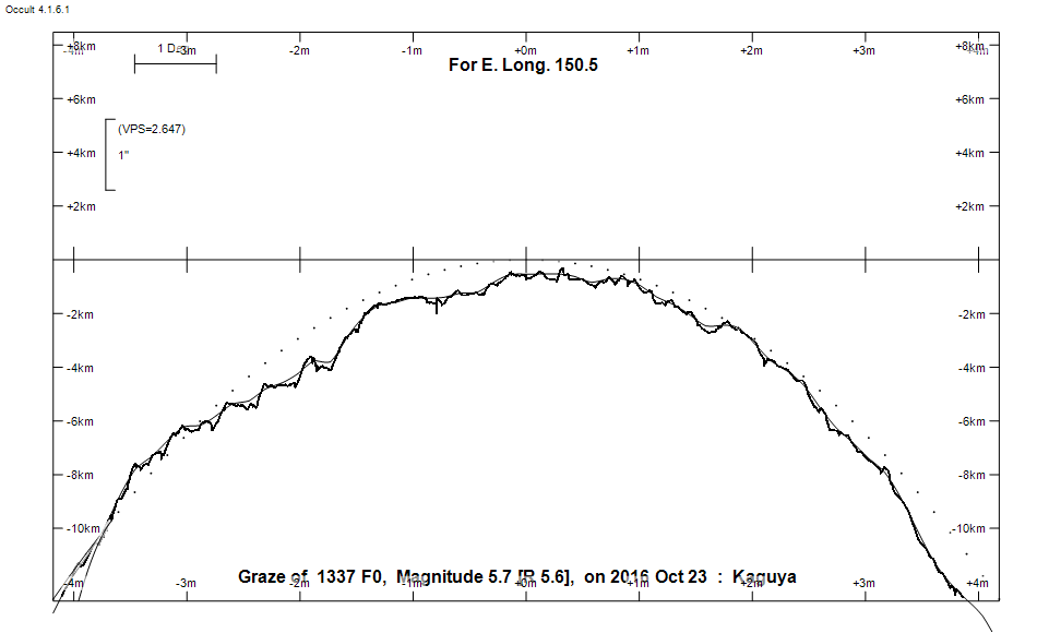
Graze profile
Grazing Occultation of    1337 F0      Magnitude 5.7 [Red = 5.6]
   R1337 = omicron 2 Cancri
Date: 2016 Oct 23 17h 37m,  to  2016 Oct 23 18h  1m

Nominal site altitude 100m

E. Longit.   Latitude       U.T.    Sun  Moon   TanZ   PA    AA      CA
   o  '  "    o  '   "    h  m  s   Alt Alt Az          o     o      o
 135  0  0  -28 38 27.2  17 36 44       15  63  3.74   7.8 350.15   8.07N
 135 30  0  -28 32  7.9  17 37  4       15  62  3.61   7.8 350.22   8.01N
 136  0  0  -28 25 54.0  17 37 24       16  62  3.49   7.9 350.29   7.94N
 136 30  0  -28 19 46.4  17 37 45       16  62  3.38   8.0 350.36   7.87N
 137  0  0  -28 13 45.4  17 38  6       17  61  3.27   8.0 350.43   7.80N
 137 30  0  -28  7 50.8  17 38 29       17  61  3.17   8.1 350.50   7.73N
 138  0  0  -28  2  3.5  17 38 52       18  61  3.08   8.2 350.58   7.65N
 138 30  0  -27 56 23.2  17 39 16       19  60  2.99   8.3 350.65   7.57N
 139  0  0  -27 50 50.2  17 39 41       19  60  2.90   8.3 350.73   7.50N
 139 30  0  -27 45 24.6  17 40  7       20  60  2.82   8.4 350.81   7.41N
 140  0  0  -27 40  6.7  17 40 33       20  59  2.74   8.5 350.90   7.33N
 140 30  0  -27 34 56.6  17 41  0       21  59  2.67   8.6 350.98   7.25N
 141  0  0  -27 29 54.6  17 41 29       21  59  2.60   8.7 351.07   7.16N
 141 30  0  -27 25  0.8  17 41 58       22  58  2.53   8.8 351.16   7.07N
 142  0  0  -27 20 15.4  17 42 27       22  58  2.46   8.9 351.25   6.98N
 142 30  0  -27 15 38.6  17 42 58       23  57  2.40   9.0 351.34   6.89N
 143  0  0  -27 11 10.7  17 43 30       23  57  2.34   9.0 351.44   6.79N
 143 30  0  -27  6 51.8  17 44  2       24  57  2.29   9.1 351.54   6.69N
 144  0  0  -27  2 42.2  17 44 36       24  56  2.23   9.2 351.64   6.59N
 144 30  0  -26 58 42.1  17 45 10       25  56  2.18   9.3 351.74   6.49N
 145  0  0  -26 54 51.7  17 45 45       25  55  2.13   9.4 351.84   6.39N
 145 30  0  -26 51 11.2  17 46 21       26  55  2.08   9.6 351.95   6.28N
 146  0  0  -26 47 41.0  17 46 58       26  55  2.03   9.7 352.06   6.17N
 146 30  0  -26 44 21.1  17 47 36       27  54  1.99   9.8 352.17   6.06N
 147  0  0  -26 41 11.9  17 48 14       27  54  1.94   9.9 352.28   5.94N
 147 30  0  -26 38 13.5  17 48 54       28  53  1.90  10.0 352.40   5.83N
 148  0  0  -26 35 26.3  17 49 35       28  53  1.86  10.1 352.52   5.71N
 148 30  0  -26 32 50.5  17 50 16       29  52  1.82  10.2 352.64   5.59N
 149  0  0  -26 30 26.2  17 50 59       29  52  1.79  10.4 352.76   5.47N
 149 30  0  -26 28 13.8  17 51 42       30  51  1.75  10.5 352.89   5.34N
 150  0  0  -26 26 13.5  17 52 26       30  51  1.72  10.6 353.01   5.22N
 150 30  0  -26 24 25.6  17 53 12       31  50  1.68  10.7 353.14   5.09N
 151  0  0  -26 22 50.2  17 53 58       31  50  1.65  10.9 353.28   4.95N
 151 30  0  -26 21 27.8  17 54 45       32  49  1.62  11.0 353.41   4.82N
 152  0  0  -26 20 18.5  17 55 33       32  49  1.59  11.2 353.55   4.68N
 152 30  0  -26 19 22.5  17 56 22       33  48  1.56  11.3 353.69   4.54N
 153  0  0  -26 18 40.2  17 57 12       33  47  1.53  11.4 353.83   4.40N
 153 30  0  -26 18 11.8  17 58  3       34  47  1.50  11.6 353.97   4.26N
 154  0  0  -26 17 57.5  17 58 55       34  46  1.48  11.7 354.11   4.11N
 154 30  0  -26 17 57.6  17 59 47       35  46  1.45  11.9 354.26   3.97N
 155  0  0  -26 18 12.4  18  0 41       35  45  1.43  12.0 354.41   3.82N

Path coordinates are referred to WGS84 (as used by GPS), with the
nominal site altitude being referenced to Mean Sea Level. The path
is adjusted for the effects of refraction at low moon altitudes.


                Librations  Long +8.15   Lat +2.52
                            P +352.23     D -3.40
      Illumination of moon  40%-
        Elongation of Moon  78
    Vertical Profile Scale  approx. 2.66 km/arcsec at mean distance of moon
   Horizontal Scale Factor  1.46 deg/min


At longitude 145.00:
Limiting Magnitudes for various telescope apertures (in cm)
      CA\Tdia   5    10    15    20    25    30    35
     2.4      4.8   6.2   7.0   7.4   7.7   7.9   8.1
     4.4      5.6   7.0   7.8   8.3   8.6   8.8   9.0
     6.4      5.6   7.0   7.8   8.3   8.6   8.9   9.0
     8.4      5.6   7.0   7.8   8.3   8.6   8.9   9.1
    10.4      5.6   7.1   7.8   8.3   8.7   8.9   9.1

------------------------------------------------------------------------------
Results of Observer Scan                                    UT
Site                              Long.   Lat.   Dist.    h  m  s
AU Mid                            143.0  -30.6   374km   17 43 29.8
Brisbane                          153.1  -27.5   128km   17 57 17.0
Bundaberg                         152.3  -24.8   170km   17 56  5.6
Lunar Limb Profile