Predictions for Grazing Occultation of ZC2365, 2016 Nov 2
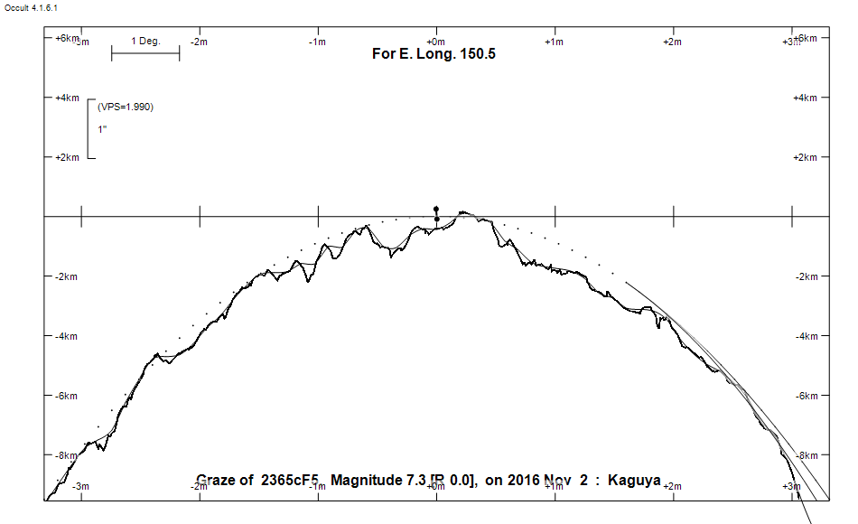
Graze profile
Grazing Occultation of    2365cF5      Magnitude 7.3 [Red = 0.0]
Date: 2016 Nov 02  8h 43m,  to  2016 Nov 02  9h  0m

Nominal site altitude 100m

E. Longit.   Latitude       U.T.    Sun  Moon   TanZ   PA    AA      CA
   o  '  "    o  '   "    h  m  s   Alt Alt Az          o     o      o
 135  0  0  -28  1 11.5   8 42 55    7  33 268  1.52   3.5 354.56   4.40N
 135 30  0  -27 55  4.1   8 43 36    6  33 268  1.56   3.4 354.48   4.32N
 136  0  0  -27 48 51.2   8 44 16    6  32 267  1.60   3.3 354.41   4.25N
 136 30  0  -27 42 32.7   8 44 55    5  31 267  1.63   3.2 354.33   4.18N
 137  0  0  -27 36  8.9   8 45 33    5  31 267  1.67   3.2 354.27   4.11N
 137 30  0  -27 29 39.8   8 46 11    4  30 266  1.71   3.1 354.20   4.05N
 138  0  0  -27 23  5.6   8 46 47    3  30 266  1.75   3.0 354.13   3.98N
 138 30  0  -27 16 26.3   8 47 23    3  29 266  1.79   3.0 354.07   3.92N
 139  0  0  -27  9 42.2   8 47 58    2  29 265  1.84   2.9 354.01   3.85N
 139 30  0  -27  2 53.2   8 48 33    2  28 265  1.88   2.8 353.95   3.79N
 140  0  0  -26 55 59.6   8 49  6    1  27 265  1.93   2.8 353.89   3.73N
 140 30  0  -26 49  1.3   8 49 39    1  27 264  1.98   2.7 353.83   3.68N
 141  0  0  -26 41 58.6   8 50 11    0  26 264  2.03   2.7 353.77   3.62N
 141 30  0  -26 34 51.6   8 50 42   -1  26 264  2.08   2.6 353.72   3.57N
 142  0  0  -26 27 40.3   8 51 13   -1  25 264  2.13   2.6 353.67   3.52N
 142 30  0  -26 20 24.9   8 51 43   -2  25 263  2.19   2.5 353.62   3.46N
 143  0  0  -26 13  5.4   8 52 12   -2  24 263  2.25   2.5 353.57   3.41N
 143 30  0  -26  5 42.0   8 52 40   -3  23 263  2.31   2.4 353.52   3.37N
 144  0  0  -25 58 14.7   8 53  8   -3  23 262  2.37   2.4 353.47   3.32N
 144 30  0  -25 50 43.8   8 53 35   -4  22 262  2.44   2.3 353.42   3.27N
 145  0  0  -25 43  9.2   8 54  1   -5  22 262  2.51   2.3 353.38   3.23N
 145 30  0  -25 35 31.0   8 54 26   -5  21 261  2.58   2.2 353.34   3.19N
 146  0  0  -25 27 49.5   8 54 51   -6  21 261  2.66   2.2 353.30   3.14N
 146 30  0  -25 20  4.6   8 55 15   -6  20 261  2.74   2.1 353.26   3.10N
 147  0  0  -25 12 16.5   8 55 38   -7  19 261  2.83   2.1 353.22   3.07N
 147 30  0  -25  4 25.3   8 56  1   -7  19 260  2.92   2.1 353.17   3.02N
 148  0  0  -24 56 31.0   8 56 22   -8  18 260  3.01   2.0 353.13   2.98N
 148 30  0  -24 48 33.8   8 56 44   -8  18 260  3.11   2.0 353.10   2.95N
 149  0  0  -24 40 33.8   8 57  4   -9  17 260  3.21   2.0 353.06   2.91N
 149 30  0  -24 32 31.0   8 57 24   -9  17 259  3.33   1.9 353.03   2.88N
 150  0  0  -24 24 25.5   8 57 43  -10  16 259  3.44   1.9 353.00   2.85N
 150 30  0  -24 16 17.4   8 58  2  -11  16 259  3.57   1.9 352.97   2.82N
 151  0  0  -24  8  6.4   8 58 19  -11  15 259  3.70   1.8 352.94   2.79N
 151 30  0  -23 59 53.4   8 58 37  -12  15 258  3.85   1.8 352.91   2.76N
 152  0  0  -23 51 38.0   8 58 53       14 258  4.00   1.8 352.88   2.73N
 152 30  0  -23 43 20.4   8 59  9       14 258  4.17   1.7 352.86   2.71N
 153  0  0  -23 35  0.6   8 59 24       13 258  4.34   1.7 352.83   2.68N
 153 30  0  -23 26 38.8   8 59 39       12 257  4.54   1.7 352.81   2.66N
 154  0  0  -23 18 14.9   8 59 52       12 257  4.74   1.7 352.78   2.63N
 154 30  0  -23  9 49.2   9  0  6       11 257  4.97   1.6 352.76   2.61N
 155  0  0  -23  1 21.5   9  0 18       11 257  5.22   1.6 352.74   2.59N

Path coordinates are referred to WGS84 (as used by GPS), with the
nominal site altitude being referenced to Mean Sea Level. The path
is adjusted for the effects of refraction at low moon altitudes.

2365 is double:
  Graze prediction is based on the mean position of AB 7.60 8.78 0.27"  53.4
 (RST3950) Graze path of A approximately 0.1 km north, and 0.1 secs earlier compared to prediction
  Graze path of B approximately 0.2 km south, and 0.4 secs later compared to prediction
  - refer to graze profile for exact distances

  AB 7.60 8.78 0.27"  53.4 (RST3950) Graze path of B approximately 0.3 km south, and 0.5 secs later compared to A
  - refer to graze profile for exact distances

                Librations  Long -3.28   Lat -6.78
                            P +353.74     D +7.37
      Illumination of moon  6%+
        Elongation of Moon  28
    Vertical Profile Scale  approx. 1.91 km/arcsec at mean distance of moon
   Horizontal Scale Factor  1.66 deg/min


At longitude 145.00:
Limiting Magnitudes for various telescope apertures (in cm)
      CA\Tdia   5    10    15    20    25    30    35
    -0.8      5.9   7.3   8.0   8.4   8.7   8.9   9.0
     1.2      6.0   7.3   8.0   8.4   8.7   8.9   9.0
     3.2      6.0   7.3   8.0   8.4   8.7   8.9   9.0
     5.2      6.0   7.3   8.0   8.4   8.7   8.9   9.0
     7.2      6.0   7.3   8.0   8.4   8.7   8.9   9.0

------------------------------------------------------------------------------
Results of Observer Scan                                    UT
Site                              Long.   Lat.   Dist.    h  m  s
Bundaberg                         152.3  -24.8   109km    8 59  3.5
Rockhampton                       150.5  -23.4    96km    8 58  1.4
Lunar Limb Profile