Predictions for Grazing Occultation of ZC 653, 2016 Nov 15
Graze profile
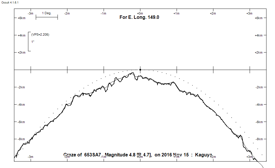
Grazing Occultation of     653SA7      Magnitude 4.8 [Red = 4.7]
   R653 = 64 delta 2 Tauri
Date: 2016 Nov 15 11h 44m,  to  2016 Nov 15 12h  0m

Nominal site altitude 100m

E. Longit.   Latitude       U.T.    Sun  Moon   TanZ   PA    AA      CA
   o  '  "    o  '   "    h  m  s   Alt Alt Az          o     o      o
 135  0  0  -40 36 24.5  11 44 17       10  57  5.94 343.8 353.07  24.20N
 135 30  0  -40 24 40.1  11 44 28       10  57  5.67 343.8 353.02  24.25N
 136  0  0  -40 12 50.9  11 44 40       10  56  5.41 343.7 352.98  24.29N
 136 30  0  -40  0 57.2  11 44 52       11  56  5.18 343.7 352.94  24.34N
 137  0  0  -39 48 58.8  11 45  5       11  56  4.96 343.6 352.89  24.38N
 137 30  0  -39 36 55.8  11 45 19       12  55  4.76 343.6 352.85  24.42N
 138  0  0  -39 24 48.2  11 45 33       12  55  4.58 343.6 352.81  24.47N
 138 30  0  -39 12 36.1  11 45 47       13  55  4.40 343.5 352.76  24.51N
 139  0  0  -39  0 19.4  11 46  3       13  54  4.24 343.5 352.72  24.55N
 139 30  0  -38 47 58.2  11 46 19       14  54  4.09 343.4 352.68  24.59N
 140  0  0  -38 35 32.5  11 46 35       14  53  3.94 343.4 352.64  24.63N
 140 30  0  -38 23  2.1  11 46 52       15  53  3.81 343.3 352.60  24.68N
 141  0  0  -38 10 28.3  11 47 10       15  53  3.68 343.3 352.56  24.72N
 141 30  0  -37 57 49.3  11 47 28       16  52  3.56 343.3 352.52  24.76N
 142  0  0  -37 45  5.9  11 47 47       16  52  3.45 343.2 352.48  24.80N
 142 30  0  -37 32 18.2  11 48  7       17  51  3.34 343.2 352.44  24.84N
 143  0  0  -37 19 26.2  11 48 27       17  51  3.24 343.1 352.40  24.87N
 143 30  0  -37  6 29.8  11 48 48       18  51  3.14 343.1 352.36  24.91N
 144  0  0  -36 53 29.5  11 49 10       18  50  3.05 343.1 352.32  24.95N
 144 30  0  -36 40 25.0  11 49 32       19  50  2.96 343.0 352.28  24.99N
 145  0  0  -36 27 16.5  11 49 55       19  49  2.87 343.0 352.25  25.02N
 145 30  0  -36 14  4.1  11 50 19       20  49  2.79 343.0 352.21  25.06N
 146  0  0  -36  0 47.7  11 50 44       20  49  2.72 342.9 352.18  25.09N
 146 30  0  -35 47 27.4  11 51  9       21  48  2.64 342.9 352.14  25.13N
 147  0  0  -35 34  3.4  11 51 35       21  48  2.57 342.9 352.11  25.16N
 147 30  0  -35 20 35.7  11 52  2       22  47  2.50 342.8 352.08  25.19N
 148  0  0  -35  7  4.3  11 52 29       22  47  2.44 342.8 352.04  25.23N
 148 30  0  -34 53 29.5  11 52 57       23  47  2.38 342.8 352.01  25.26N
 149  0  0  -34 39 51.2  11 53 26       23  46  2.32 342.7 351.98  25.29N
 149 30  0  -34 26  9.6  11 53 56       24  46  2.26 342.7 351.96  25.32N
 150  0  0  -34 12 24.7  11 54 27       24  45  2.20 342.7 351.93  25.34N
 150 30  0  -33 58 36.8  11 54 58       25  45  2.15 342.7 351.90  25.37N
 151  0  0  -33 44 45.9  11 55 31       25  44  2.10 342.6 351.88  25.39N
 151 30  0  -33 30 52.2  11 56  4       26  44  2.05 342.6 351.85  25.42N
 152  0  0  -33 16 55.7  11 56 38       27  43  2.00 342.6 351.83  25.44N
 152 30  0  -33  2 56.6  11 57 13       27  43  1.96 342.6 351.81  25.46N
 153  0  0  -32 48 55.0  11 57 48       28  42  1.91 342.5 351.79  25.48N
 153 30  0  -32 34 51.2  11 58 25       28  42  1.87 342.5 351.77  25.50N
 154  0  0  -32 20 45.2  11 59  2       29  41  1.83 342.5 351.76  25.52N
 154 30  0  -32  6 37.2  11 59 41       29  41  1.79 342.5 351.74  25.53N
 155  0  0  -31 52 27.3  12  0 20       30  40  1.75 342.5 351.73  25.55N

Path coordinates are referred to WGS84 (as used by GPS), with the
nominal site altitude being referenced to Mean Sea Level. The path
is adjusted for the effects of refraction at low moon altitudes.

Projected diameter of star  1 meters  [CHARM/CADARS, 6 measures]

653 is quadruple:
  This next pair is not confirmed
  ** 5.6 5.6 0.040"  53.0 (OCc 952) Graze path of ? approximately 0.0 km south, and 0.1 secs later compared to the primary
  - refer to graze profile for exact distances
  AC 4.4 9.6 10.8"  83.0 (DRS  37) Graze path of C approximately 4.8 km north, and 21.0 secs later compared to A
  - refer to graze profile for exact distances
  AB 4.8 14.6 148" 248.4 (BUP  56) Graze path of B approximately 30.3 km north, and 290.4 secs earlier compared to A
  - refer to graze profile for exact distances

                Librations  Long +3.05   Lat +5.92
                            P +352.52     D -6.02
      Illumination of moon  98%-
        Elongation of Moon  165
    Vertical Profile Scale  approx. 2.37 km/arcsec at mean distance of moon
   Horizontal Scale Factor  1.74 deg/min


At longitude 145.00:
Limiting Magnitudes for various telescope apertures (in cm)
      CA\Tdia   5    10    15    20    25    30    35
    21.0      4.0   5.3   6.0   6.4   6.6   6.8   6.9
    23.0      4.0   5.3   6.0   6.4   6.6   6.8   6.9
    25.0      4.0   5.3   6.0   6.4   6.6   6.8   6.9
    27.0      4.0   5.3   6.0   6.4   6.6   6.8   6.9
    29.0      4.1   5.4   6.1   6.5   6.7   6.9   7.0

------------------------------------------------------------------------------
Results of Observer Scan                                    UT
Site                              Long.   Lat.   Dist.    h  m  s
AU Mid                            143.0  -30.6   667km   11 48 27.3
Bendigo                           144.3  -36.8     5km   11 49 24.8
Canberra                          149.2  -35.3    66km   11 53 35.4
Melbourne                         145.0  -37.8   131km   11 49 53.8
Newcastle                         151.7  -33.0    45km   11 56 18.6
Pt Macquarie                      152.8  -31.4   145km   11 57 36.5
Sydney                            151.1  -33.8    11km   11 55 35.3
Lunar Limb Profile