Predictions for Grazing Occultation of SAO1611834, 2016 Dec 2
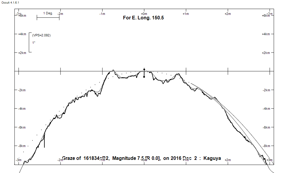
Graze profile
Grazing Occultation of  161834cB2      Magnitude 7.5 [Red = 0.0]
Date: 2016 Dec 02  9h 19m,  to  2016 Dec 02  9h 34m

Nominal site altitude 100m

E. Longit.   Latitude       U.T.    Sun  Moon   TanZ   PA    AA      CA
   o  '  "    o  '   "    h  m  s   Alt Alt Az          o     o      o
 135  0  0  -29 55 35.9   9 18 50    5  31 266  1.67 349.5 355.27   1.82N
 135 30  0  -29 43 54.0   9 19 28    4  30 265  1.71 349.5 355.26   1.81N
 136  0  0  -29 32 10.9   9 20  6    4  30 265  1.75 349.5 355.25   1.81N
 136 30  0  -29 20 26.9   9 20 42    3  29 264  1.79 349.5 355.25   1.80N
 137  0  0  -29  8 42.1   9 21 18    2  29 264  1.83 349.5 355.24   1.80N
 137 30  0  -28 56 56.6   9 21 53    2  28 264  1.88 349.5 355.24   1.79N
 138  0  0  -28 45 10.7   9 22 27    1  27 263  1.92 349.5 355.24   1.79N
 138 30  0  -28 33 24.4   9 23  0    1  27 263  1.97 349.5 355.23   1.79N
 139  0  0  -28 21 37.9   9 23 33    0  26 263  2.02 349.5 355.23   1.79N
 139 30  0  -28  9 51.4   9 24  5   -1  26 262  2.07 349.5 355.24   1.79N
 140  0  0  -27 58  4.9   9 24 36   -1  25 262  2.13 349.5 355.24   1.79N
 140 30  0  -27 46 18.6   9 25  6   -2  25 261  2.19 349.5 355.24   1.80N
 141  0  0  -27 34 32.7   9 25 35   -2  24 261  2.25 349.5 355.25   1.80N
 141 30  0  -27 22 47.3   9 26  4   -3  23 261  2.31 349.5 355.25   1.81N
 142  0  0  -27 11  2.5   9 26 32   -3  23 260  2.37 349.5 355.26   1.82N
 142 30  0  -26 59 18.4   9 26 59   -4  22 260  2.44 349.6 355.27   1.83N
 143  0  0  -26 47 35.2   9 27 25   -5  22 260  2.51 349.6 355.28   1.84N
 143 30  0  -26 35 53.0   9 27 51   -5  21 260  2.59 349.6 355.29   1.85N
 144  0  0  -26 24 11.8   9 28 15   -6  21 259  2.66 349.6 355.30   1.86N
 144 30  0  -26 12 31.8   9 28 39   -6  20 259  2.75 349.6 355.32   1.87N
 145  0  0  -26  0 53.2   9 29  3   -7  19 259  2.83 349.6 355.33   1.89N
 145 30  0  -25 49 15.9   9 29 25   -7  19 258  2.92 349.6 355.34   1.90N
 146  0  0  -25 37 40.2   9 29 47   -8  18 258  3.02 349.6 355.36   1.92N
 146 30  0  -25 26  6.0   9 30  8   -9  18 258  3.12 349.7 355.37   1.93N
 147  0  0  -25 14 33.5   9 30 28   -9  17 258  3.23 349.7 355.39   1.95N
 147 30  0  -25  3  3.2   9 30 48  -10  17 257  3.34 349.7 355.41   1.97N
 148  0  0  -24 51 34.5   9 31  6  -10  16 257  3.46 349.7 355.43   1.99N
 148 30  0  -24 40  7.8   9 31 24  -11  16 257  3.59 349.7 355.45   2.01N
 149  0  0  -24 28 42.4   9 31 42  -11  15 256  3.73 349.7 355.47   2.03N
 149 30  0  -24 17 19.8   9 31 58  -12  14 256  3.88 349.8 355.49   2.05N
 150  0  0  -24  5 59.4   9 32 14       14 256  4.04 349.8 355.51   2.07N
 150 30  0  -23 54 41.3   9 32 30       13 256  4.21 349.8 355.53   2.09N
 151  0  0  -23 43 25.6   9 32 44       13 256  4.40 349.8 355.56   2.11N
 151 30  0  -23 32 12.2   9 32 58       12 255  4.60 349.9 355.58   2.14N
 152  0  0  -23 21  1.4   9 33 11       12 255  4.81 349.9 355.60   2.16N
 152 30  0  -23  9 53.1   9 33 24       11 255  5.05 349.9 355.63   2.19N
 153  0  0  -22 58 47.5   9 33 35       11 255  5.31 349.9 355.66   2.21N
 153 30  0  -22 47 44.5   9 33 47       10 254  5.60 350.0 355.68   2.24N
 154  0  0  -22 36 44.2   9 33 57       10 254  5.92 350.0 355.71   2.27N
 154 30  0  -22 25 46.7   9 34  7        9 254  6.27 350.0 355.74   2.29N
 155  0  0  -22 14 52.0   9 34 16        9 254  6.67 350.0 355.76   2.32N

Path coordinates are referred to WGS84 (as used by GPS), with the
nominal site altitude being referenced to Mean Sea Level. The path
is adjusted for the effects of refraction at low moon altitudes.

161834 is double:
  Graze prediction is based on the mean position of AB 7.75 9.00 0.40" 153.2
 (RST3198) Graze path of A approximately 0.2 km south, and 0.1 secs earlier compared to prediction
  Graze path of B approximately 0.6 km north, and 0.2 secs later compared to prediction
  - refer to graze profile for exact distances

  AB 7.75 9.00 0.40" 153.2 (RST3198) Graze path of B approximately 0.7 km north, and 0.2 secs later compared to A
  - refer to graze profile for exact distances

                Librations  Long -5.31   Lat -5.76
                            P +355.88     D +6.44
      Illumination of moon  7%+
        Elongation of Moon  31
    Vertical Profile Scale  approx. 2.01 km/arcsec at mean distance of moon
   Horizontal Scale Factor  1.78 deg/min


At longitude 145.00:
Limiting Magnitudes for various telescope apertures (in cm)
      CA\Tdia   5    10    15    20    25    30    35
    -2.1      5.6   7.0   7.7   8.2   8.5   8.7   8.8
    -0.1      5.8   7.2   8.0   8.4   8.7   8.9   9.1
     1.9      5.8   7.2   8.0   8.4   8.7   8.9   9.1
     3.9      5.8   7.2   8.0   8.4   8.7   8.9   9.1
     5.9      5.8   7.3   8.0   8.4   8.7   8.9   9.1

------------------------------------------------------------------------------
Results of Observer Scan                                    UT
Site                              Long.   Lat.   Dist.    h  m  s
Bundaberg                         152.3  -24.8   162km    9 33 19.4
Rockhampton                       150.5  -23.4    56km    9 32 29.5
Lunar Limb Profile