Predictions for Grazing Occultation of ZC2128, 2016 Feb 28
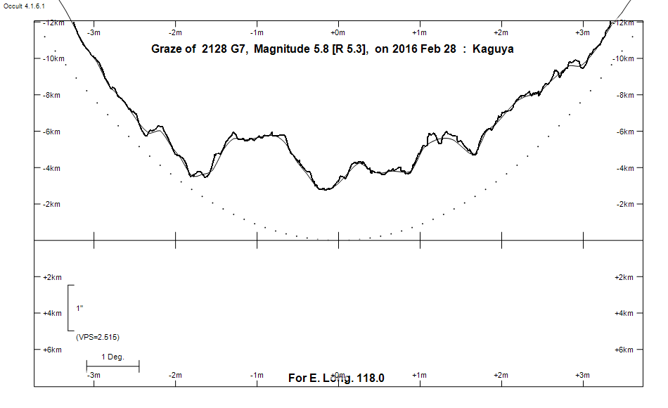
Graze profile
Grazing Occultation of    2128 G7      Magnitude 5.8 [Red = 5.3]
   R2128 = 13 Librae
Date: 2016 Feb 28 16h 34m,  to  2016 Feb 28 17h  1m

Nominal site altitude 100m

E. Longit.   Latitude       U.T.    Sun  Moon   TanZ   PA    AA      CA
   o  '  "    o  '   "    h  m  s   Alt Alt Az          o     o      o
 110  0  0  -31 14 39.5  16 34 17       25  89  2.10 201.0 183.37   6.51S
 110 30  0  -31 27 20.3  16 34 57       26  88  2.05 201.1 183.43   6.57S
 111  0  0  -31 40  9.0  16 35 39       27  88  2.00 201.2 183.49   6.63S
 111 30  0  -31 53  5.3  16 36 21       27  88  1.95 201.2 183.54   6.69S
 112  0  0  -32  6  9.2  16 37  3       28  87  1.90 201.3 183.60   6.75S
 112 30  0  -32 19 20.6  16 37 47       28  87  1.86 201.3 183.66   6.80S
 113  0  0  -32 32 39.4  16 38 32       29  86  1.81 201.4 183.72   6.86S
 113 30  0  -32 46  5.3  16 39 18       29  86  1.77 201.4 183.77   6.92S
 114  0  0  -32 59 38.4  16 40  4       30  85  1.73 201.5 183.83   6.97S
 114 30  0  -33 13 18.3  16 40 52       31  84  1.69 201.5 183.88   7.02S
 115  0  0  -33 27  5.1  16 41 40       31  84  1.66 201.6 183.93   7.07S
 115 30  0  -33 40 58.4  16 42 29       32  83  1.62 201.6 183.98   7.12S
 116  0  0  -33 54 58.2  16 43 20       32  83  1.59 201.7 184.03   7.17S
 116 30  0  -34  9  4.2  16 44 11       33  82  1.55 201.7 184.08   7.22S
 117  0  0  -34 23 16.3  16 45  2       33  82  1.52 201.8 184.12   7.27S
 117 30  0  -34 37 34.2  16 45 55       34  81  1.49 201.8 184.17   7.31S
 118  0  0  -34 51 57.6  16 46 49       34  80  1.46 201.9 184.21   7.35S
 118 30  0  -35  6 26.5  16 47 43       35  80  1.43 201.9 184.25   7.39S
 119  0  0  -35 21  0.3  16 48 38       36  79  1.40 202.0 184.29   7.43S
 119 30  0  -35 35 39.0  16 49 34       36  78  1.37 202.0 184.33   7.47S
 120  0  0  -35 50 22.3  16 50 31       37  78  1.35 202.0 184.36   7.51S
 120 30  0  -36  5  9.7  16 51 28       37  77  1.32 202.1 184.39   7.54S
 121  0  0  -36 20  1.0  16 52 26       38  76  1.30 202.1 184.43   7.57S
 121 30  0  -36 34 56.0  16 53 25       38  75  1.27 202.1 184.46   7.60S
 122  0  0  -36 49 54.4  16 54 24       39  75  1.25 202.1 184.48   7.63S
 122 30  0  -37  4 55.7  16 55 24       39  74  1.23 202.2 184.51   7.65S
 123  0  0  -37 19 59.7  16 56 25       40  73  1.20 202.2 184.53   7.67S
 123 30  0  -37 35  6.1  16 57 26       40  72  1.18 202.2 184.55   7.69S
 124  0  0  -37 50 14.5  16 58 28       41  71  1.16 202.2 184.57   7.71S
 124 30  0  -38  5 24.5  16 59 31       41  71  1.14 202.2 184.58   7.73S
 125  0  0  -38 20 35.8  17  0 33       42  70  1.12 202.3 184.60   7.74S

Path coordinates are referred to WGS84 (as used by GPS), with the
nominal site altitude being referenced to Mean Sea Level. The path
is adjusted for the effects of refraction at low moon altitudes.

Projected diameter of star  2 meters  [Estimated]


    C A S S I N I   R E G I O N   G R A Z E
                Librations  Long -3.17   Lat -6.01
                            P +184.50     D -5.50
      Illumination of moon  71%-
        Elongation of Moon  114
    Vertical Profile Scale  approx. 2.36 km/arcsec at mean distance of moon
   Horizontal Scale Factor  1.56 deg/min


At longitude 117.50:
Limiting Magnitudes for various telescope apertures (in cm)
      CA\Tdia   5    10    15    20    25    30    35
     3.3      4.6   6.1   6.8   7.3   7.6   7.8   8.0
     5.3      4.7   6.1   6.9   7.3   7.7   7.9   8.0
     7.3      5.5   6.9   7.7   8.2   8.5   8.7   8.9
     9.3      5.5   6.9   7.7   8.2   8.5   8.7   8.9
    11.3      5.5   6.9   7.7   8.2   8.5   8.8   8.9

------------------------------------------------------------------------------
Results of Observer Scan                                    UT
Site                              Long.   Lat.   Dist.    h  m  s
Albany                            117.8  -35.0    20km   16 46 30.9
Perth                             115.9  -32.0   184km   16 43  4.6
Lunar Limb Profile