Predictions for Grazing Occultation of ZC3334, 2016 Apr 4
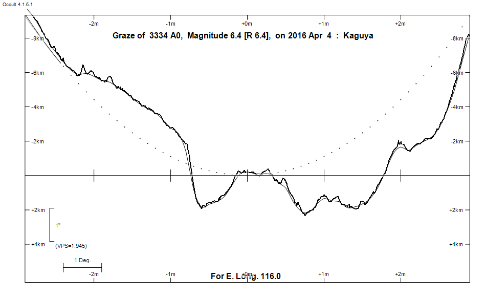
Graze profile
Grazing Occultation of    3334 A0      Magnitude 6.4 [Red = 6.4]
   R3334 = 67 Aquarii
Date: 2016 Apr 04 20h 37m,  to  2016 Apr 04 20h 41m

Nominal site altitude 100m

E. Longit.   Latitude       U.T.    Sun  Moon   TanZ   PA    AA      CA
   o  '  "    o  '   "    h  m  s   Alt Alt Az          o     o      o
 110  0  0  -32 26 27.2  20 37 10        5  95 10.92 165.3 188.91   5.52S
 110 30  0  -32 29 18.3  20 37 13        6  95 10.08 165.2 188.86   5.47S
 111  0  0  -32 32  5.5  20 37 17        6  94  9.35 165.2 188.80   5.42S
 111 30  0  -32 34 48.6  20 37 21        7  94  8.72 165.1 188.75   5.37S
 112  0  0  -32 37 27.6  20 37 25        7  94  8.17 165.1 188.70   5.31S
 112 30  0  -32 40  2.4  20 37 29        7  93  7.68 165.0 188.65   5.26S
 113  0  0  -32 42 33.1  20 37 34        8  93  7.25 165.0 188.59   5.21S
 113 30  0  -32 44 59.5  20 37 39        8  93  6.86 164.9 188.54   5.15S
 114  0  0  -32 47 21.6  20 37 44        9  93  6.51 164.9 188.48   5.10S
 114 30  0  -32 49 39.4  20 37 50        9  92  6.19 164.8 188.43   5.04S
 115  0  0  -32 51 52.8  20 37 57       10  92  5.90 164.8 188.37   4.99S
 115 30  0  -32 54  1.9  20 38  3       10  92  5.63 164.7 188.32   4.93S
 116  0  0  -32 56  6.5  20 38 10       11  91  5.39 164.6 188.26   4.87S
 116 30  0  -32 58  6.6  20 38 17       11  91  5.16 164.6 188.20   4.81S
 117  0  0  -33  0  2.3  20 38 25       11  91  4.96 164.5 188.14   4.75S
 117 30  0  -33  1 53.3  20 38 33       12  91  4.76 164.5 188.08   4.70S
 118  0  0  -33  3 39.8  20 38 41       12  90  4.58 164.4 188.02   4.64S
 118 30  0  -33  5 21.6  20 38 50       13  90  4.42 164.4 187.96   4.57S
 119  0  0  -33  6 58.8  20 38 59       13  90  4.26 164.3 187.90   4.51S
 119 30  0  -33  8 31.2  20 39  9       14  89  4.11 164.2 187.84   4.45S
 120  0  0  -33  9 58.8  20 39 19       14  89  3.98 164.2 187.78   4.39S
 120 30  0  -33 11 21.6  20 39 29       15  89  3.85 164.1 187.71   4.33S
 121  0  0  -33 12 39.5  20 39 40       15  88  3.73 164.0 187.65   4.26S
 121 30  0  -33 13 52.7  20 39 51       15  88  3.61 164.0 187.58   4.20S
 122  0  0  -33 15  0.7  20 40  3       16  88  3.50 163.9 187.52   4.13S
 122 30  0  -33 16  3.6  20 40 14       16  88  3.40 163.8 187.45   4.07S
 123  0  0  -33 17  1.5  20 40 27       17  87  3.30 163.8 187.39   4.00S
 123 30  0  -33 17 54.1  20 40 39       17  87  3.21 163.7 187.32   3.93S
 124  0  0  -33 18 41.7  20 40 52       18  87  3.12 163.6 187.25   3.86S
 124 30  0  -33 19 24.1  20 41  6       18  86  3.03 163.6 187.18   3.79S
 125  0  0  -33 20  1.2  20 41 20       19  86  2.95 163.5 187.11   3.73S

Path coordinates are referred to WGS84 (as used by GPS), with the
nominal site altitude being referenced to Mean Sea Level. The path
is adjusted for the effects of refraction at low moon altitudes.


                Librations  Long -4.56   Lat -1.62
                            P +188.17     D -0.70
      Illumination of moon  9%-
        Elongation of Moon  36
    Vertical Profile Scale  approx. 1.93 km/arcsec at mean distance of moon
   Horizontal Scale Factor  1.98 deg/min


At longitude 117.50:
Limiting Magnitudes for various telescope apertures (in cm)
      CA\Tdia   5    10    15    20    25    30    35
     0.7      6.1   7.5   8.3   8.9   9.2   9.5   9.7
     2.7      6.1   7.6   8.4   8.9   9.3   9.6   9.8
     4.7      6.2   7.7   8.5   9.0   9.4   9.6   9.8
     6.7      6.2   7.7   8.5   9.0   9.4   9.7   9.9
     8.7      6.3   7.7   8.6   9.1   9.5   9.7  10.0

------------------------------------------------------------------------------
Results of Observer Scan                                    UT
Site                              Long.   Lat.   Dist.    h  m  s
Albany                            117.8  -35.0   216km   20 38 38.7
Perth                             115.9  -32.0   108km   20 38  8.0
Lunar Limb Profile