Predictions for Grazing Occultation of ZC3280, 2016 May 1
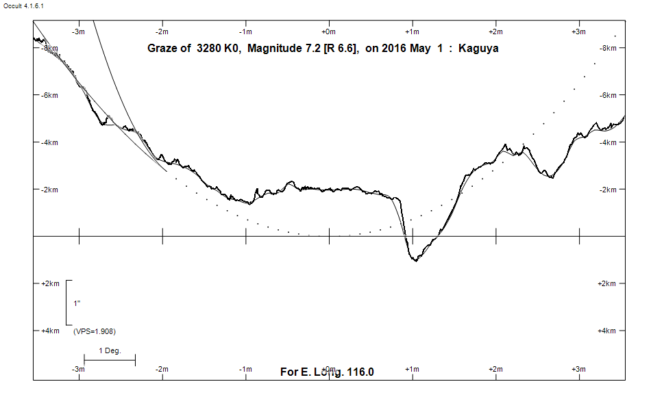
Graze profile
Grazing Occultation of    3280 K0      Magnitude 7.2 [Red = 6.6]
Date: 2016 May 01 20h  9m,  to  2016 May 01 20h 24m

Nominal site altitude 100m

E. Longit.   Latitude       U.T.    Sun  Moon   TanZ   PA    AA      CA
   o  '  "    o  '   "    h  m  s   Alt Alt Az          o     o      o
 110  0  0  -32 45 18.4  20  9  0       27  83  1.93 163.8 186.47   4.27S
 110 30  0  -32 45 18.8  20  9 23       28  82  1.89 163.7 186.38   4.19S
 111  0  0  -32 45 12.8  20  9 47       28  82  1.85 163.6 186.29   4.10S
 111 30  0  -32 45  0.5  20 10 10       29  82  1.82 163.5 186.21   4.01S
 112  0  0  -32 44 41.7  20 10 35       29  81  1.78 163.4 186.12   3.93S
 112 30  0  -32 44 16.5  20 11  0       30  81  1.74 163.3 186.03   3.84S
 113  0  0  -32 43 44.7  20 11 25       30  80  1.71 163.2 185.94   3.75S
 113 30  0  -32 43  6.2  20 11 51       31  80  1.67 163.2 185.85   3.66S
 114  0  0  -32 42 21.0  20 12 17       31  80  1.64 163.1 185.76   3.56S
 114 30  0  -32 41 29.0  20 12 44       32  79  1.61 163.0 185.66   3.47S
 115  0  0  -32 40 30.2  20 13 11       32  79  1.58 162.9 185.57   3.38S
 115 30  0  -32 39 24.4  20 13 39       33  79  1.55 162.8 185.47   3.28S
 116  0  0  -32 38 11.7  20 14  8       33  78  1.52 162.7 185.38   3.19S
 116 30  0  -32 36 51.8  20 14 37       34  78  1.49 162.6 185.28   3.09S
 117  0  0  -32 35 24.8  20 15  6       34  77  1.46 162.5 185.18   2.99S
 117 30  0  -32 33 50.6  20 15 36       35  77  1.43 162.4 185.08   2.89S
 118  0  0  -32 32  9.0  20 16  6       35  77  1.40 162.3 184.98   2.79S
 118 30  0  -32 30 20.1  20 16 38       36  76  1.38 162.2 184.88   2.69S
 119  0  0  -32 28 23.7  20 17  9       37  76  1.35 162.1 184.78   2.59S
 119 30  0  -32 26 19.7  20 17 41       37  75  1.32 162.0 184.68   2.48S
 120  0  0  -32 24  8.1  20 18 14       38  75  1.30 161.9 184.57   2.38S
 120 30  0  -32 21 48.8  20 18 47       38  74  1.27 161.8 184.47   2.27S
 121  0  0  -32 19 21.7  20 19 21       39  74  1.25 161.7 184.36   2.17S
 121 30  0  -32 16 46.7  20 19 55       39  74  1.23 161.6 184.25   2.06S
 122  0  0  -32 14  3.7  20 20 30       40  73  1.20 161.5 184.15   1.96S
 122 30  0  -32 11 12.6  20 21  6       40  73  1.18 161.3 184.04   1.85S
 123  0  0  -32  8 13.4  20 21 42       41  72  1.16 161.2 183.93   1.74S
 123 30  0  -32  5  6.0  20 22 18       41  72  1.14 161.1 183.82   1.63S
 124  0  0  -32  1 50.2  20 22 56       42  71  1.11 161.0 183.70   1.51S
 124 30  0  -31 58 25.9  20 23 34       42  71  1.09 160.9 183.59   1.40S
 125  0  0  -31 54 53.2  20 24 12       43  70  1.07 160.8 183.47   1.28S

Path coordinates are referred to WGS84 (as used by GPS), with the
nominal site altitude being referenced to Mean Sea Level. The path
is adjusted for the effects of refraction at low moon altitudes.

Projected diameter of star  2 meters  [Estimated]


    C A S S I N I   R E G I O N   G R A Z E
                Librations  Long -5.93   Lat -2.10
                            P +185.25     D -1.31
      Illumination of moon  31%-
        Elongation of Moon  68
    Vertical Profile Scale  approx. 1.92 km/arcsec at mean distance of moon
   Horizontal Scale Factor  1.61 deg/min


At longitude 117.50:
Limiting Magnitudes for various telescope apertures (in cm)
      CA\Tdia   5    10    15    20    25    30    35
    -1.1      3.3   4.7   5.4   5.8   6.1   6.3   6.5
     0.9      5.1   6.5   7.3   7.8   8.1   8.4   8.6
     2.9      5.1   6.5   7.3   7.8   8.1   8.4   8.6
     4.9      5.1   6.5   7.3   7.8   8.2   8.4   8.6
     6.9      5.9   7.3   8.1   8.7   9.0   9.3   9.5

------------------------------------------------------------------------------
Results of Observer Scan                                    UT
Site                              Long.   Lat.   Dist.    h  m  s
Lunar Limb Profile