Predictions for Grazing Occultation of ZC 354, 2016 Sep 19
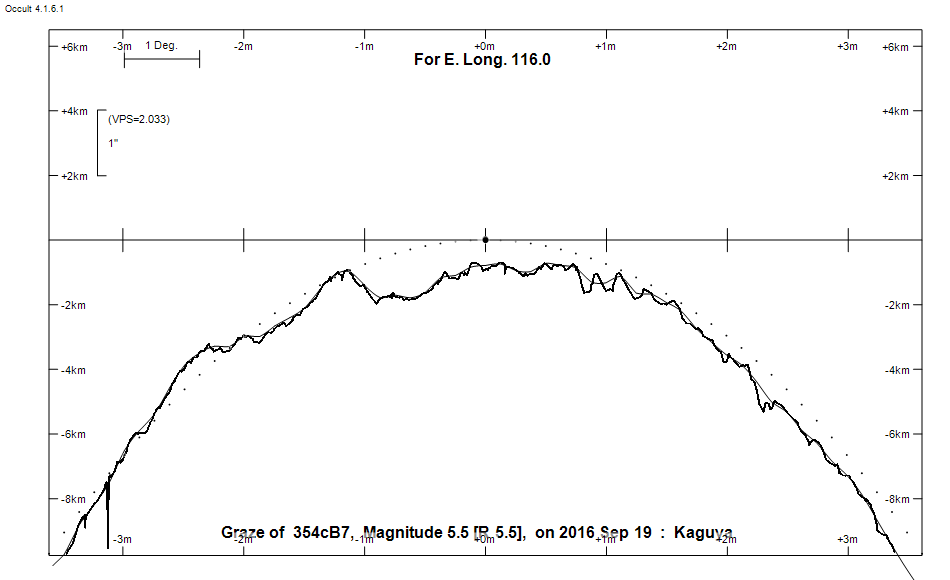
Graze profile
Grazing Occultation of     354cB7      Magnitude 5.5 [Red = 5.5]  v
   R354 = xi Arietis
Date: 2016 Sep 19 16h  3m,  to  2016 Sep 19 16h 25m

Nominal site altitude 100m

E. Longit.   Latitude       U.T.    Sun  Moon   TanZ   PA    AA      CA
   o  '  "    o  '   "    h  m  s   Alt Alt Az          o     o      o
 110  0  0  -35 22 22.0  16  3 15       26  53  2.02 336.3 355.85   9.50N
 110 30  0  -35 10 33.3  16  3 47       27  52  1.97 336.2 355.78   9.57N
 111  0  0  -34 58 37.2  16  4 19       27  52  1.93 336.2 355.71   9.64N
 111 30  0  -34 46 33.6  16  4 51       28  52  1.88 336.1 355.63   9.71N
 112  0  0  -34 34 22.6  16  5 25       29  51  1.84 336.0 355.56   9.79N
 112 30  0  -34 22  4.1  16  5 59       29  51  1.80 335.9 355.49   9.86N
 113  0  0  -34  9 38.1  16  6 34       30  50  1.76 335.9 355.41   9.93N
 113 30  0  -33 57  4.5  16  7 10       30  50  1.72 335.8 355.34  10.01N
 114  0  0  -33 44 23.4  16  7 47       31  49  1.68 335.7 355.27  10.08N
 114 30  0  -33 31 34.7  16  8 25       31  49  1.65 335.6 355.19  10.15N
 115  0  0  -33 18 38.5  16  9  3       32  48  1.61 335.6 355.12  10.23N
 115 30  0  -33  5 34.7  16  9 43       32  48  1.58 335.5 355.05  10.30N
 116  0  0  -32 52 23.3  16 10 23       33  47  1.54 335.4 354.98  10.37N
 116 30  0  -32 39  4.3  16 11  4       34  47  1.51 335.4 354.91  10.44N
 117  0  0  -32 25 37.8  16 11 46       34  46  1.48 335.3 354.84  10.51N
 117 30  0  -32 12  3.8  16 12 29       35  46  1.45 335.2 354.77  10.58N
 118  0  0  -31 58 22.3  16 13 13       35  45  1.42 335.1 354.70  10.65N
 118 30  0  -31 44 33.3  16 13 58       36  45  1.39 335.1 354.63  10.72N
 119  0  0  -31 30 36.9  16 14 44       36  44  1.36 335.0 354.56  10.79N
 119 30  0  -31 16 33.0  16 15 30       37  44  1.33 334.9 354.49  10.85N
 120  0  0  -31  2 21.8  16 16 18       38  43  1.30 334.9 354.43  10.92N
 120 30  0  -30 48  3.2  16 17  7       38  42  1.27 334.8 354.36  10.99N
 121  0  0  -30 33 37.5  16 17 56       39  42  1.25 334.7 354.30  11.05N
 121 30  0  -30 19  4.6  16 18 47       39  41  1.22 334.7 354.23  11.11N
 122  0  0  -30  4 24.6  16 19 39       40  41  1.20 334.6 354.17  11.17N
 122 30  0  -29 49 37.5  16 20 31       40  40  1.17 334.6 354.11  11.24N
 123  0  0  -29 34 43.6  16 21 25       41  39  1.15 334.5 354.05  11.29N
 123 30  0  -29 19 43.0  16 22 20       42  39  1.12 334.4 353.99  11.35N
 124  0  0  -29  4 35.6  16 23 15       42  38  1.10 334.4 353.94  11.41N
 124 30  0  -28 49 21.8  16 24 12       43  37  1.08 334.3 353.88  11.46N
 125  0  0  -28 34  1.6  16 25 10       43  37  1.06 334.3 353.83  11.52N

Path coordinates are referred to WGS84 (as used by GPS), with the
nominal site altitude being referenced to Mean Sea Level. The path
is adjusted for the effects of refraction at low moon altitudes.

354 is variable:
       354 = HIP 11249, 5.48, range 0.00, 7V, Type VAR, Period 1.73515 days

354 is double:
  This next pair is not confirmed
  ** 6.3 6.3 0.050"  46.0 (OCc 984) Graze path of ? approximately 0.0 km south, and 0.1 secs later compared to the primary
  - refer to graze profile for exact distances

    C A S S I N I   R E G I O N   G R A Z E
                Librations  Long +1.87   Lat +5.10
                            P +354.91     D -4.99
      Illumination of moon  88%-
        Elongation of Moon  139
    Vertical Profile Scale  approx. 2.13 km/arcsec at mean distance of moon
   Horizontal Scale Factor  1.59 deg/min


At longitude 117.50:
Limiting Magnitudes for various telescope apertures (in cm)
      CA\Tdia   5    10    15    20    25    30    35
     6.6      4.5   5.9   6.6   7.1   7.4   7.6   7.8
     8.6      4.5   5.9   6.6   7.1   7.4   7.6   7.8
    10.6      4.9   6.3   7.1   7.5   7.8   8.0   8.2
    12.6      5.3   6.8   7.5   8.0   8.3   8.6   8.7
    14.6      5.4   6.8   7.6   8.0   8.3   8.6   8.7

------------------------------------------------------------------------------
AAVSO Variable star entry

       Variable identifier           Type        Max    Min  Ph  Epoch         Period
       HIP 11249                     VAR         5.48 ( 0.007V                  1.73515
------------------------------------------------------------------------------
Results of Observer Scan                                    UT
Site                              Long.   Lat.   Dist.    h  m  s
Perth                             115.9  -32.0    97km   16 10 10.8
Lunar Limb Profile