Predictions for Grazing Occultation of ZC2690, 2016 Oct 8
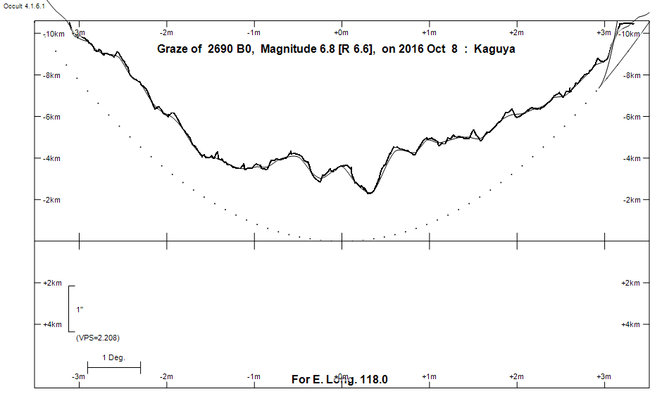
Graze profile
Grazing Occultation of    2690 B0      Magnitude 6.8 [Red = 6.6]  v
Date: 2016 Oct 08 13h 44m,  to  2016 Oct 08 14h  2m

Nominal site altitude 100m

E. Longit.   Latitude       U.T.    Sun  Moon   TanZ   PA    AA      CA
   o  '  "    o  '   "    h  m  s   Alt Alt Az          o     o      o
 110  0  0  -37 33 20.0  13 44  5       38 276  1.26 171.5 175.64   4.39S
 110 30  0  -37 22 53.4  13 44 48       38 275  1.28 171.5 175.60   4.44S
 111  0  0  -37 12 22.5  13 45 31       37 275  1.31 171.5 175.56   4.48S
 111 30  0  -37  1 47.4  13 46 14       37 274  1.33 171.4 175.53   4.51S
 112  0  0  -36 51  8.4  13 46 56       36 274  1.36 171.4 175.49   4.55S
 112 30  0  -36 40 25.4  13 47 37       36 273  1.38 171.4 175.46   4.58S
 113  0  0  -36 29 38.8  13 48 19       35 272  1.41 171.3 175.43   4.61S
 113 30  0  -36 18 48.6  13 48 59       35 272  1.44 171.3 175.40   4.64S
 114  0  0  -36  7 55.0  13 49 39       34 271  1.47 171.3 175.37   4.67S
 114 30  0  -35 56 58.2  13 50 19       34 271  1.50 171.2 175.34   4.70S
 115  0  0  -35 45 58.3  13 50 57       33 270  1.53 171.2 175.31   4.72S
 115 30  0  -35 34 55.4  13 51 36       33 270  1.56 171.2 175.29   4.75S
 116  0  0  -35 23 49.7  13 52 14       32 269  1.59 171.2 175.27   4.77S
 116 30  0  -35 12 41.4  13 52 51       32 269  1.63 171.1 175.25   4.79S
 117  0  0  -35  1 30.7  13 53 28       31 268  1.66 171.1 175.23   4.81S
 117 30  0  -34 50 17.6  13 54  4       30 268  1.70 171.1 175.21   4.83S
 118  0  0  -34 39  2.4  13 54 39       30 267  1.74 171.1 175.19   4.85S
 118 30  0  -34 27 45.2  13 55 14       29 267  1.77 171.1 175.17   4.86S
 119  0  0  -34 16 26.1  13 55 49       29 267  1.81 171.1 175.16   4.88S
 119 30  0  -34  5  5.3  13 56 23       28 266  1.86 171.0 175.15   4.89S
 120  0  0  -33 53 43.0  13 56 56       28 266  1.90 171.0 175.13   4.90S
 120 30  0  -33 42 19.2  13 57 28       27 265  1.94 171.0 175.12   4.91S
 121  0  0  -33 30 54.1  13 58  1       27 265  1.99 171.0 175.11   4.92S
 121 30  0  -33 19 27.9  13 58 32       26 264  2.04 171.0 175.10   4.93S
 122  0  0  -33  8  0.7  13 59  3       26 264  2.09 171.0 175.10   4.94S
 122 30  0  -32 56 32.7  13 59 33       25 264  2.14 171.0 175.09   4.94S
 123  0  0  -32 45  4.0  14  0  2       25 263  2.19 171.0 175.09   4.95S
 123 30  0  -32 33 34.7  14  0 31       24 263  2.25 171.0 175.08   4.95S
 124  0  0  -32 22  4.9  14  1  0       23 262  2.31 171.0 175.08   4.95S
 124 30  0  -32 10 34.9  14  1 27       23 262  2.37 171.0 175.08   4.96S
 125  0  0  -31 59  4.6  14  1 54       22 262  2.43 171.0 175.08   4.96S

Path coordinates are referred to WGS84 (as used by GPS), with the
nominal site altitude being referenced to Mean Sea Level. The path
is adjusted for the effects of refraction at low moon altitudes.

2690 is variable:
      2690 = V4398 Sgr, 6.89 to 6.93, Hp, Type ACYG, Period 2.42048 days, Phase 89 %


    C A S S I N I   R E G I O N   G R A Z E
                Librations  Long -6.61   Lat -6.46
                            P +175.92     D -6.73
      Illumination of moon  43%+
        Elongation of Moon  82
    Vertical Profile Scale  approx. 2.08 km/arcsec at mean distance of moon
   Horizontal Scale Factor  1.65 deg/min


At longitude 117.50:
Limiting Magnitudes for various telescope apertures (in cm)
      CA\Tdia   5    10    15    20    25    30    35
     0.8      4.9   6.3   7.0   7.5   7.8   8.1   8.2
     2.8      4.9   6.3   7.1   7.5   7.9   8.1   8.2
     4.8      5.7   7.1   7.9   8.4   8.7   9.0   9.2
     6.8      5.7   7.1   7.9   8.4   8.8   9.0   9.2
     8.8      5.7   7.1   7.9   8.4   8.8   9.0   9.2

------------------------------------------------------------------------------
Results of Observer Scan                                    UT
Site                              Long.   Lat.   Dist.    h  m  s
Albany                            117.8  -35.0    29km   13 54 27.5
Lunar Limb Profile