Predictions for Grazing Occultation of ZC3189, 2016 Nov 8
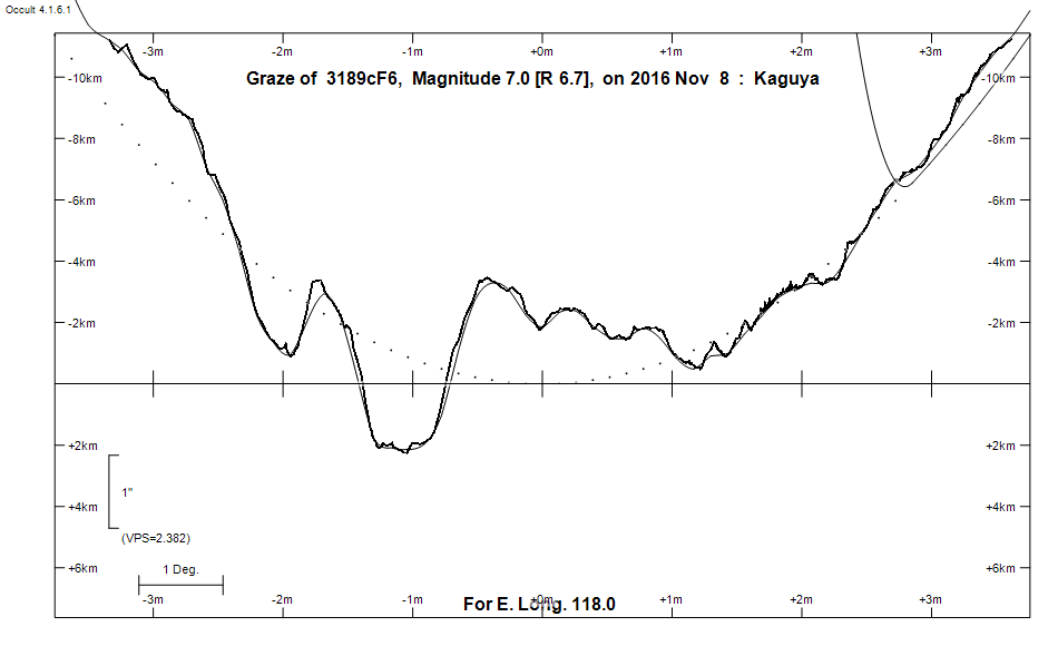
Graze profile
Grazing Occultation of    3189cF6      Magnitude 7.0 [Red = 6.7]
   R3189 = 50 Capricorni
Date: 2016 Nov 08 13h 24m,  to  2016 Nov 08 13h 55m

Nominal site altitude 100m

E. Longit.   Latitude       U.T.    Sun  Moon   TanZ   PA    AA      CA
   o  '  "    o  '   "    h  m  s   Alt Alt Az          o     o      o
 110  0  0  -38 19 47.4  13 24  7       51 304  0.81 156.4 177.39   4.40S
 110 30  0  -38  4 19.7  13 25 15       50 303  0.83 156.4 177.37   4.42S
 111  0  0  -37 48 48.3  13 26 22       50 302  0.84 156.4 177.35   4.44S
 111 30  0  -37 33 13.7  13 27 29       50 301  0.85 156.4 177.33   4.46S
 112  0  0  -37 17 36.3  13 28 36       49 299  0.86 156.4 177.32   4.47S
 112 30  0  -37  1 56.4  13 29 43       49 298  0.87 156.4 177.31   4.48S
 113  0  0  -36 46 14.4  13 30 49       48 297  0.89 156.3 177.31   4.48S
 113 30  0  -36 30 30.7  13 31 56       48 296  0.90 156.3 177.30   4.49S
 114  0  0  -36 14 45.7  13 33  2       48 295  0.92 156.3 177.30   4.49S
 114 30  0  -35 58 59.7  13 34  8       47 294  0.93 156.3 177.30   4.49S
 115  0  0  -35 43 13.1  13 35 13       47 293  0.95 156.3 177.30   4.49S
 115 30  0  -35 27 26.4  13 36 19       46 292  0.96 156.4 177.31   4.48S
 116  0  0  -35 11 39.8  13 37 23       46 291  0.98 156.4 177.32   4.47S
 116 30  0  -34 55 53.9  13 38 28       45 290  0.99 156.4 177.33   4.46S
 117  0  0  -34 40  9.0  13 39 32       45 290  1.01 156.4 177.35   4.44S
 117 30  0  -34 24 25.5  13 40 35       44 289  1.03 156.4 177.36   4.43S
 118  0  0  -34  8 43.7  13 41 38       44 288  1.05 156.4 177.38   4.41S
 118 30  0  -33 53  4.1  13 42 40       43 287  1.07 156.4 177.40   4.39S
 119  0  0  -33 37 27.0  13 43 42       43 286  1.09 156.5 177.43   4.36S
 119 30  0  -33 21 52.6  13 44 43       42 285  1.11 156.5 177.45   4.34S
 120  0  0  -33  6 21.4  13 45 44       41 285  1.13 156.5 177.48   4.31S
 120 30  0  -32 50 53.7  13 46 44       41 284  1.15 156.6 177.51   4.28S
 121  0  0  -32 35 29.9  13 47 43       40 283  1.18 156.6 177.54   4.25S
 121 30  0  -32 20 10.1  13 48 42       40 282  1.20 156.6 177.58   4.21S
 122  0  0  -32  4 54.9  13 49 40       39 282  1.22 156.7 177.62   4.17S
 122 30  0  -31 49 44.3  13 50 37       39 281  1.25 156.7 177.66   4.13S
 123  0  0  -31 34 38.9  13 51 33       38 280  1.27 156.7 177.70   4.09S
 123 30  0  -31 19 38.7  13 52 29       38 280  1.30 156.8 177.74   4.05S
 124  0  0  -31  4 44.1  13 53 24       37 279  1.33 156.8 177.78   4.00S
 124 30  0  -30 49 55.3  13 54 18       36 278  1.36 156.9 177.83   3.96S
 125  0  0  -30 35 12.6  13 55 11       36 278  1.39 156.9 177.88   3.91S

Path coordinates are referred to WGS84 (as used by GPS), with the
nominal site altitude being referenced to Mean Sea Level. The path
is adjusted for the effects of refraction at low moon altitudes.


    C A S S I N I   R E G I O N   G R A Z E
                Librations  Long -7.93   Lat -2.23
                            P +177.66     D -2.33
      Illumination of moon  57%+
        Elongation of Moon  99
    Vertical Profile Scale  approx. 2.26 km/arcsec at mean distance of moon
   Horizontal Scale Factor  1.54 deg/min


At longitude 117.50:
Limiting Magnitudes for various telescope apertures (in cm)
      CA\Tdia   5    10    15    20    25    30    35
     0.4      3.1   4.5   5.3   5.7   6.0   6.2   6.4
     2.4      4.9   6.3   7.1   7.6   7.9   8.2   8.4
     4.4      5.7   7.2   8.0   8.5   8.8   9.1   9.3
     6.4      5.7   7.2   8.0   8.5   8.8   9.1   9.3
     8.4      5.7   7.2   8.0   8.5   8.9   9.1   9.3

------------------------------------------------------------------------------
Results of Observer Scan                                    UT
Site                              Long.   Lat.   Dist.    h  m  s
Albany                            117.8  -35.0    72km   13 41 16.9
Lunar Limb Profile