![]()
|
|
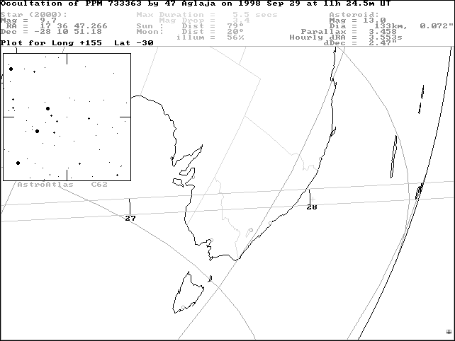
Edwin Goffin's original prediction for this event places the path across the extreme southern tip of southeastern Australia.
On September 22 Gordon Garradd using CCD equipment at the Loomberah Observatory obtained seven astrometric positions of the asteroid alone. Reduction using the star position from the PPM catalog suggests a new track about one path width (ca. 140 km) NORTH of the original prediction. The updated track runs between Melbourne and Adelaide, and north of Canberra. Sites in northern Victoria, and eastern NSW (including Bathurst) fall within the updated track, which exits the coast near Port Macquarie.
Event time is approximately 11h 27.5 minutes for SE Australia. (Note however that observations should be carried out for at least ten minutes either side of this time). With the star at magnitude 9.7 and asteroid at magnitude 13, observers should be prepared for the star to disappear completely should an occultation occur.
The update map below has been generated using OCCULT software. It shows the updated central line of the occultation shadow. Remember that the actual shadow will be approximately 140 km wide.
CHECK THIS PAGE REGULARLY (USE YOUR BROWSER'S RELOAD BUTTON) FOR FURTHER UPDATES AND CHANGES TO THE TRACK!
Use these links for further information:
[Aglaja star charts and event details]
[Planetary Occultations]
[Using the Predictions]
[Observing Details]
[Timing Details]
[Reporting Details]
[Report Form]
![[Aglaja star charts and event details]](../predict/p980929.gif)